Webinar recordings are available for FREE and immediate download in our online store.
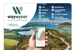
The presentation will show how the system revolutionizes the management of trails to allow inputs from IOT devices, volunteer trail crews, and citizen science applications.
This presentation summarizes how the Trail Vision platform digitizes trail management— utilizing technology to collect, analyze, and visualize critical trail information, to make better, more informed decisions.
This webinar discusses the National Digital Trails project accomplishments, future steps, and provides a demonstration of the TRAILS tool.
Using anonymized mobility data via location intelligence technologies to look at park and trail usage.
The Colorado Mountain Club’s Recreation Impact Monitoring System (RIMS) mobile app will allow trail users, volunteers, and staff to gather data on trails, signage, camping, visitor use, and more.
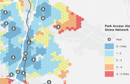
Join this webinar to learn more about strategies to bring the power of GIS to create a more equitable park and greenway system.
The use of emerging and evolving technologies such as drones, photogrammetry, RTK GPS, 3D modeling, and LiDAR technology to inventory and analyze existing trail conditions.
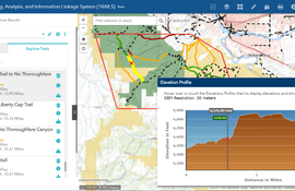
The US Geological Survey and DOI are advancing the vision to provide better access to public lands and improve connectivity on the nation’s public trail systems with the National Digital Trails Network (NDT) project. Join us for an overview of the project and a demonstration of the Trail Routing, Analysis, and Information Linkage System (TRAILS) tool.
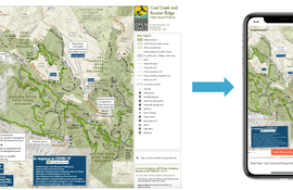
This webinar will share a spectrum of data analysis and scenario planning tools that can be used to help plan and design new or existing trails.
This webinar will introduce participants to new tools and technologies being used to advance trail projects around the country.