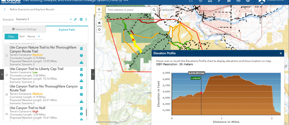
The US Geological Survey and DOI are advancing the vision to provide better access to public lands and improve connectivity on the nation’s public trail systems with the National Digital Trails Network (NDT) project. Join us for an overview of the project and a demonstration of the Trail Routing, Analysis, and Information Linkage System (TRAILS) tool.
Presented by:
** This event has passed **
September 17, 2020
10:00 AM to 11:00 AM (Pacific Time) {more time zones}
Cost (RECORDING):
FREE for membersNote:
Closed Captioning is available for this webinar.
Learning Credits are available for this webinar.
This webinar is free. Would you consider a donation to support this webinar?
Our Nation is home to a vast network of recreational trails traveled by millions of citizens. This trail network varies in age from hundreds of years old to brand new, and its purpose spans from recreation to critical transportation routes. Trail content also varies by managing organization. Because of this varied legacy, existing trails do not form a coherent, connected network. The overall objective of this project is to increase the connectivity within the trail network.
The Department of Interior (DOI) has prioritized a vision to provide better access to public lands and improve connectivity on the nation’s public trail systems. The US Geological Survey and DOI are advancing that vision with the National Digital Trails Network (NDT) project. The project consists of three primary goals:
Join us for an overview of the project and a demonstration of the Trail Routing, Analysis, and Information Linkage System (TRAILS) tool.

This webinar qualifies as a Health, Safety, and Welfare (HSW) course (via LA CES).
Elizabeth McCartney, Cartographer, U.S. Geological Survey
Rolla, Missouri

Elizabeth McCartney is a cartographer with the US Geological Survey (USGS), National Geospatial Program, in Rolla Missouri. Currently Elizabeth serves as the Project Manager for the National Digital Trails Project. Her past roles include Applied Research at the USGS National Geospatial Technical Operations Center, team leader for the USGS Volunteered Geographic Information project known as The National Map Corps, and regional Point of Contact for the USGS National Hydrography Dataset.
Tatyana DiMascio, Technical Lead, U.S. Geological Survey
Denver, Colorado

Tatyana DiMascio is a cartographer with the US Geological Survey’s National Geospatial Technical Operations Center in Denver, Colorado. She received her MS in Environmental Management from Duke University and has dedicated the last 15 years as a GIS professional in environmental planning, hydrography, and recreation in both private and public sectors.
We are offering closed captioning for our webinars, thanks to a partnership with VZP Digital. If you are in need of this service, please email us prior to the webinar. An unedited transcript will be sent to all attendees following the webinar.
American Trails is proud to be a certified provider of the following learning credits and continuing education opportunities:
Learning credits are free for attendees for American Trails webinars and the International Trails Symposium, as well as for other conferences, webinars, and workshops we offer credits for. Learn more here.
While we may individually agree (or disagree) in whole or in part with any or all of the participants, the views expressed in these webinars are not necessarily representative of the views of American Trails as an organization or its board and staff. Unless specific situations are noted by presenters, nothing in American Trails webinars should be considered to be interpreted as a standard.
By registering for our webinars, you submit your information to the webinar organizer and associated presenters and sponsors, who may use it to communicate with you regarding this event and their other services. Your organization may also be added to the American Trails Business Directory. You can easily cancel your registration at any time.
3,732 views • posted 08/18/2020