Increasing Access and Opportunities
This webinar discusses the National Digital Trails project accomplishments, future steps, and provides a demonstration of the TRAILS tool.
Presented by:
** This event has passed **
November 17, 2022
10:00 AM to 11:00 AM (Pacific Time) {more time zones}
Cost (RECORDING):
FREE for membersNote:
Closed Captioning is available for this webinar.
Learning Credits are available for this webinar.
This webinar is free. Would you consider a donation to support this webinar?
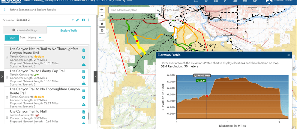
Our Nation is home to thousands of miles of trails maintained by many different land management agencies and organizations. Since January 2019, the U.S. Geological Survey’s National Digital Trails (NDT) project has been supporting the U.S. Department of the Interior’s priority of improving access to our nation’s public lands. The first objective was to help improve connectivity between existing trails and trail networks by developing a trail planning support tool for assisting land managers in identifying and prioritizing candidate trails. Utilizing geospatial analysis, the web-based Trail Routing, Analysis, and Information Linkage System (TRAILS) enables land managers to visualize optimal connector routes between existing trails based on slope, land ownership, transportation, surface water, and user-defined custom areas. Secondly, the project was tasked with the creation of a nationwide, public domain, geospatial trail dataset which includes trails from key federal land management agencies and many states. A robust trail network supports increased access and expands recreational opportunities over public lands. This presentation discusses project accomplishments, future steps, and provides a demonstration of the TRAILS tool.

This webinar qualifies as a Health, Safety, and Welfare (HSW) course (via LA CES).
Elizabeth McCartney, Cartographer, U.S. Geological Survey
Rolla, Missouri

Elizabeth McCartney is a cartographer with the US Geological Survey (USGS), National Geospatial Program, in Rolla Missouri. Currently Elizabeth serves as the Project Manager for the National Digital Trails Project. Her past roles include Applied Research at the USGS National Geospatial Technical Operations Center, team leader for the USGS Volunteered Geographic Information project known as The National Map Corps, and regional Point of Contact for the USGS National Hydrography Dataset.
Tatyana DiMascio, Technical Lead, U.S. Geological Survey
Denver, Colorado

Tatyana DiMascio is a cartographer with the US Geological Survey’s National Geospatial Technical Operations Center in Denver, Colorado. She received her MS in Environmental Management from Duke University and has dedicated the last 15 years as a GIS professional in environmental planning, hydrography, and recreation in both private and public sectors.
We are offering closed captioning for our webinars, thanks to a partnership with VZP Digital. If you are in need of this service, please email us prior to the webinar. An unedited transcript will be sent to all attendees following the webinar.
American Trails is proud to be a certified provider of the following learning credits and continuing education opportunities:
Learning credits are free for attendees for American Trails webinars and the International Trails Symposium, as well as for other conferences, webinars, and workshops we offer credits for. Learn more here.
While we may individually agree (or disagree) in whole or in part with any or all of the participants, the views expressed in these webinars are not necessarily representative of the views of American Trails as an organization or its board and staff. Unless specific situations are noted by presenters, nothing in American Trails webinars should be considered to be interpreted as a standard.
By registering for our webinars, you submit your information to the webinar organizer and associated presenters and sponsors, who may use it to communicate with you regarding this event and their other services. Your organization may also be added to the American Trails Business Directory. You can easily cancel your registration at any time.
1,285 views • posted 07/18/2022