This webinar will share a spectrum of data analysis and scenario planning tools that can be used to help plan and design new or existing trails.
Presented by:
** This event has passed **
August 06, 2020
10:00 AM to 11:30 AM (Pacific Time) {more time zones}
Cost (RECORDING):
FREE for membersNote:
Closed Captioning is available for this webinar.
Learning Credits are available for this webinar.
This webinar is free. Would you consider a donation to support this webinar?
Thanks to a generous sponsorship from Voss Signs, this webinar (and learning credits) is free to the public.
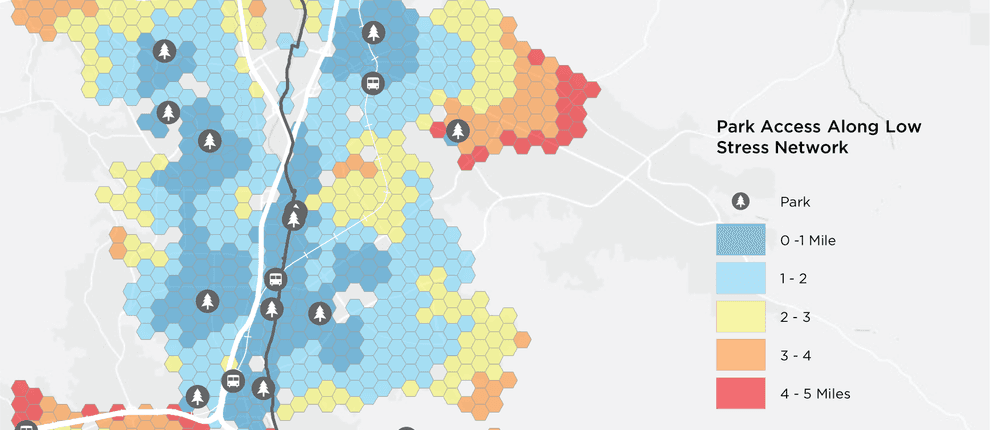
Data science tools allow an exploration of trail connectivity, demand, comfort, health, and safety needs. This webinar will share a spectrum of data analysis and scenario planning tools that can be used to help plan and design new or existing trails. We will share examples from three California trail corridors at three scales: Los Angeles River Path, an 8-mile gap closure, the Iron Horse Trial, a 22-mile regional trail, and the Great Redwood Trail, a 300-mile former rail corridor. We will present the data analysis methods used to evaluate future user demand, assess how much space is required to accommodate various levels of use by people walking, biking, using e-bikes or other electric vehicles and understand network access priorities. These tools are very effective in considering not just existing travel characteristics, but also how changes in mobility options, such as e-bikes or shared autonomous vehicles could change the use of the corridor.

This webinar qualifies as a Health, Safety, and Welfare (HSW) course (via LA CES).

Emily Duchon, Design Principal, Alta Planning + Design

Emily is experienced in helping communities design and implement innovative active transportation solutions, taking projects from master plans through concept design and construction drawings and administration. Her project experience includes bicycle, pedestrian and trail master plans as well as complete street, multi-use trail and wayfinding design. Emily is a Design Principal for the LA River Path project, closing the 8-mile gap in the LA River Bike Path in downtown LA and as project manager for the Iron Horse Trail Active Transportation Feasibility Study.
Deven Young, Design Principal, Alta Planning + Design

Deven is an experienced project manager and designer, adept at overseeing and facilitating implementation for mobility corridors, trails, parks, and open space projects. He has delivered some of the largest and most complex active transportation projects in the country and across the globe. Deven is currently a Design Principal supporting the LA River Path, The California Great Redwood Trail and the Iron Horse Trail in California, three projects making great strides toward multi-modal access for all ages and abilities.
Lauren Cencic, Sr. Director, Countywide Planning & Development, Mobility Corridors, Los Angeles County Metropolitan Transportation Authority

Mike Sellinger, Planning Associate, Alta Planning + Design

Mike Sellinger is a Planning Associate at Alta Planning + Design. His expertise is in applying analytical methods to planning for walking and biking. Mike has worked on a wide range of active transportation projects across North America from trail master plans to micromobility feasibility studies.
We are offering closed captioning for our webinars, thanks to a partnership with VZP Digital. If you are in need of this service, please email us prior to the webinar. An unedited transcript will be sent to all attendees following the webinar.
American Trails is proud to be a certified provider of the following learning credits and continuing education opportunities:
Learning credits are free for attendees for American Trails webinars and the International Trails Symposium, as well as for other conferences, webinars, and workshops we offer credits for. Learn more here.
While we may individually agree (or disagree) in whole or in part with any or all of the participants, the views expressed in these webinars are not necessarily representative of the views of American Trails as an organization or its board and staff. Unless specific situations are noted by presenters, nothing in American Trails webinars should be considered to be interpreted as a standard.
By registering for our webinars, you submit your information to the webinar organizer and associated presenters and sponsors, who may use it to communicate with you regarding this event and their other services. Your organization may also be added to the American Trails Business Directory. You can easily cancel your registration at any time.
4,362 views • posted 05/29/2020