posted Feb 19, 2018
Learn about trail training services and opportunities plus a wide variety of technical resources available.
posted Feb 19, 2018
by
Mark Wilcox with American Society of Landscape Architects,
Bill Neumann with DHM Design,
John M. Pflaum, PE
This presentation will reveal the process of planning, designing and constructing trails within four different landscape settings identifying challenges and solutions.
posted Feb 19, 2018
by
Carl Knoch with Rails to Trails Conservancy,
David Lindhaul with Morton Trails,
John Morton with Morton Trails
Hear how research projects support the facts that trails do provide a positive economic benefit in their communities.
posted Feb 19, 2018
This session will focus on the big and innovative thinking necessary to retrofit an urban environment for a multi-use trail system.
posted Feb 19, 2018
This panel will pair land managers with horse riders for a discussion of how each can help the other in meeting their goals.
posted Feb 19, 2018
by
Christopher Douwes with Federal Highway Administration,
Patricia Fisher with Oregon Department of Transportation,
Rocky Houston with Oregon Parks and Recreation Department
This presentation will discuss transportation funding programs that benefit trails and trail-related activities, focusing on Transportation Enhancement Activities and the Recreational Trails Program.
posted Feb 19, 2018
Strategies and tactics for promoting safety on urban trails.
posted Feb 19, 2018
by
Christopher Douwes with Federal Highway Administration,
Ginny Sullivan with Adventure Cycling Association
Learn how the corridor-level plan was developed in partnership with the non-profit AASHTO and join Adventure Cycling and others in promoting state adoption of an interstate route system for bikes.
posted Feb 19, 2018
by
J. Scott Groenier, PE with USDA Forest Service,
Chip Young with Florida Fish and Wildlife Conservation Commission
Today’s techno-savvy trail users expect to be able to plan and preview their trail experience with accurate GPS and GIS data viewed in programs like Google Earth.
posted Feb 19, 2018
Learn how a New York study of road and trail intersections generated policy and design recommendations and a public education campaign for trail users and motorists.

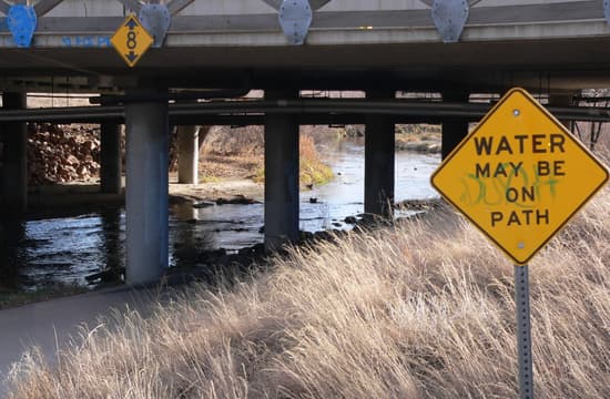
Another variation on flood warning signs, "Water may be on path" on Cherry Creek Trail; Denver, Colorado
Another variation on flood warning signs, "Water may be on path" on Cherry Creek Trail; Denver, Colorado
Another variation on flood warning signs, "Water may be on path" on Cherry Creek Trail; Denver, Colorado
Another variation on flood warning signs, "Water may be on path" on Cherry Creek Trail; Denver, Colorado
Another variation on flood warning signs, "Water may be on path" on Cherry Creek Trail; Denver, Colorado
Another variation on flood warning signs, "Water may be on path" on Cherry Creek Trail; Denver, Colorado
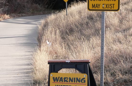
Trail may be impassable, says one of three signs approaching one underpass on the Cherry Creek Trail; Denver, Colorado
Trail may be impassable, says one of three signs approaching one underpass on the Cherry Creek Trail; Denver, Colorado
Trail may be impassable, says one of three signs approaching one underpass on the Cherry Creek Trail; Denver, Colorado


