
Multiple-Use Management and Corridor Sharing
Prospectors Loop Trails
The Prospectors Alliance had to find a safe and reasonable crossing of the Beaver River for the ATV trail to connect the north and south trails, connect Ely to Babbitt. Currently the snowmobile club had a trail which crossed about four thousand feet of spruce swamp and the existing bridge needed significant work if it was going to be used during the summer months.
Prospectors Club found another potential crossing about a quarter mile up stream that would impact
about a third of the wetland. This would involve about a mile of new trail construction and the south end
of the crossing had a very steep hill, rising about twenty feet above the wetland.
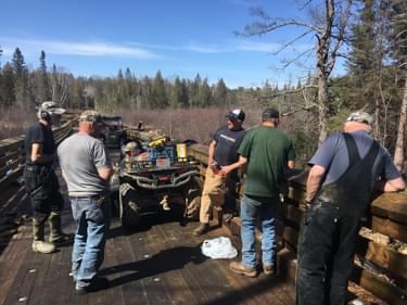
So the challenge became, design a trail that would minimize the impact on the wetland, yet allow for ATV use in the summer and snowmobile use during the winter. The snowmobile use must also accommodate grooming equipment, which requires a twelve-foot surface and at least a ten ton carry capacity. This would allow the existing snowmobile crossing to be removed and put both uses on the same trail.
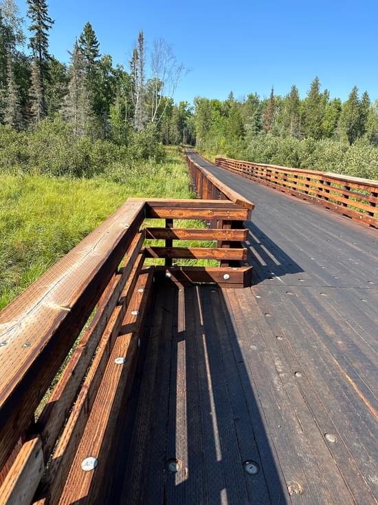
The new wetland and Beaver River crossing resulted in six hundred feet of elevated wood panels so that it could match the existing height of the bank on the south end, and keep the bridge elevated to meet the hundred year flood level. Included another five hundred feet of wood panel puncheon to complete the wetland crossing. This design did not require any filling of the wetland other than some helical pilings and some wood platforms for the segments of puncheon. Final design has a twelve-foot driving surface and rated for ten ton so it can accommodate the snowmobile grooming equipment.
This design has allowed for more multiple use of this trail system. With a high and dry crossing of the Beaver River and adjacent floodplain this trail is now seeing more use from hikers, hunters and mountain bikers. This summer this trail and this crossing was part of a long distance mountain bike race, the first time ever, made possible by this new crossing.
This provides an important connection on the existing trail system in the area. Not only does it connect the Ely and Babbitt area but it also provides a direct connection to the David Dill/Taconite State Trail. This State Trail is a natural surface, multi use trail, approximately 145 miles in length stretching across northeast Minnesota between Ely and Grand Rapids.
This trail is part of the Minnesota Trail Assistance program and receives annual maintenance funding to ensure it is maintained and remains open to the public. These maintenance funds come from the ATV dedicated account which is funded through ATV state registration and a portion of the state gas tax.
More winners of this award
2021: Doty Bridge Replacement
2020: Pine Street Woods
2019: Mount Emily Recreation Area – Oregon
2018: Wildcat Rock Trail - North Carolina
2018: Brule River Bridge - Wisconsin
2017: Middle Fork National Recreation Trail Improvements - Oregon
2016: Dolan Springs Trail - Arizona
2015: Boardman Bridge - Idaho
2014: Discovery Hill Community Trails - Idaho
2014: Yellow Creek Bridge Project - Pennsylvania
2013: Longleaf Trace Equestrian Trail Improvements and Extension - Mississippi
2012: Kwolh Butte Shelter - Oregon
2011: White River Valley Trail - Missouri
2010: Debsconeag Lakes Wilderness Area - Maine
2009: Meduxnekeag River Bridge - Maine
2008: Boundary Canal Trail (Phases I and II) - Florida
2007: Wild Rivers State Trail - Wisconsin
2006: Lake Russell Multiple-Use Trail - Georgia
2005: Johnson Camp Trail Project - California