Linking Northeast Washington, D.C.
The purpose of this study is to provide a preliminary assessment and concept plan for developing a shared-use path along the New York Avenue corridor within the defined study area. Conducted as the first phase of determining feasibility for trail development, this preliminary assessment did not include extensive stakeholder outreach but can be used to inform future public participation and stakeholder outreach efforts in the next phase of planning.
by Rails to Trails Conservancy
The concept of developing a trail along the New York Avenue corridor dates back at least a decade, when it was included in the District’s 2005 Bicycle Master Plan. Renewed interest has produced a need to further examine the concept and provide a preliminary assessment of the corridor and its potential for trail development. This study presents a closer look at current corridor conditions, opportunities and challenges and makes preliminary recommendations for a trail that could eventually become the eastern bicycle gateway into the city. Referred to as the “New York Avenue Rail-with-Trail” in this study, the name indicates its unique relationship with an active railroad corridor that has served as one of the main gateways into Washington, D.C., for more than 100 years.
The purpose of this project is to create a new multi-use trail (shared-use path) in Northeast Washington, D.C., that will improve pedestrian and bicycle access and conditions along New York Avenue, seamlessly connecting the Ivy City neighborhood with downtown. Produced as a concept plan, this study is intended to be the first planning effort to inform future, more extensive plans to develop the trail.
Rails to Trails Conservancy (RTC) is a nonprofit organization dedicated to creating a nationwide network of trails from former rail lines and connecting corridors to build healthier places for healthier people.
RTC’s mission, and its value, is magnified in urban areas, where one mile of trail can completely redefine the livability of a community. Where trails are more than just recreational amenities, creating opportunities for active transportation and physical activity—improving our health and wellbeing—as they safely connect us to jobs, schools, businesses, parks, and cultural institutions in our own neighborhoods and beyond.
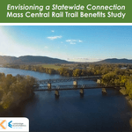
Envisioning a Statewide Connection Mass Central Rail Trail Benefits Study
posted Jun 14, 2023
Study shows completion of the Massachusetts Central Rail Trail System would bring significant health and economic benefits to the commonwealth.
posted May 15, 2023
Mountain Bike Trail Development: Guidelines for Successfully Managing the Process,” a 242-page “how to” manual covers modern trail development from trail types, to landscape analysis and design, to environmental and construction considerations, cost implications and more.
The Beerline Trail Equitable Implementation Plan – 2019
posted Sep 21, 2021
The Beerline Trail Neighborhood Development Project was created to ensure the next phases of trail development serve the needs of the community.
Planning and Managing Environmentally Friendly Mountain Bike Trails
posted Dec 22, 2020
This guidebook can be used to assist in successfully planning, designing, and constructing mountain bike trail systems, while keeping in mind that user issues must be addressed at every stage of development.
551 views • posted 07/27/2020