By Roy B. Mann, MLA The Rivers Studio, LLC, Austin, Texas
Design for trail system provides wildlife viewing and teaches about playa resources.
The semi-arid regional landscape of the American southwest that straddles the state lines of Colorado, Kansas, Nebraska, New Mexico, Oklahoma, and Texas is home to a very special natural and ephemeral resource — the playa. Playas are perennial lakes that are sustained by precipitation, have little if any outlet flow, and lose their volume to evaporation and transpiration over the course of hot summers and prolonged drought, often to the point of near to total disappearance.
As long as they hold water, they are important, often primary sources of drinking water for livestiock raised by thousands of ranchers in the region.
They are also important sources of water and nutrients for wildlife, serving significant roles in the sustaining of waterfowl health and stamina. Without playas, the intricate support system of the West Branch of the Central Flyway, vital for close to two hundred species of migratory birds ranging from Canada Goose and Sandhill Crane to Peregrine Falcon could be threatened.
Migratory waterfowl require setting-down points along their routes for rest, water, and food. For migratory terrestrial birds, the native vegetation bordering playas, where plant life is protected either by public agencies or by conservation minded ranchers and other private owners, is welcome wherever found.
With the likelihood of future rising temperatures and lowered precipitation in the region, expected with global warming, the role of the playa becomes increasingly essential to birdlife with each passing year. Playas are the primary source of recharge for the Ogallala Aquifer, contributing 85-90 percent of all recharge to the groundwater source.
Few playas are publicly protected and many of the 60,000 or so playas in the region are not conserved for wildlife. A great majority of playas, almost all of which are found on private lands, are managed for grazing, with edge vegetation cut away to improve watering access for herds. In some cases, playa waters are drained to expand sown land. Of the more than 20,000 playas in Texas, only two are in the ownership of municipalities.
With this as context, the establishment by civic leaders and the City of Midland, Texas, of a playa wildlife preserve on the city's perimeter has been welcomed by wildlife conservation, birding, and ecotourism interests in Texas and beyond. The news is also good news to the people of Midland and recreationists and birders throughout the Southern Staked Plains.
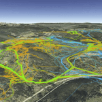
The quantum leap from undedicated city land appreciated by the few familiar with its hidden flora and fauna to regional asset was made possible by the civic activism of Midland natives Paul L. Davis, Jr. and Elaine Magruder, founders of Friends of the I-20 Playa Wildlife Preserve, and the support of the City of Midland. The Rivers Studio, LLC, park, preserve, and trail planners, were retained in September of 2006 to prepare a master plan for landscape restoration, trails and observation points, and access to and from a nature study center to be built on adjacent land.
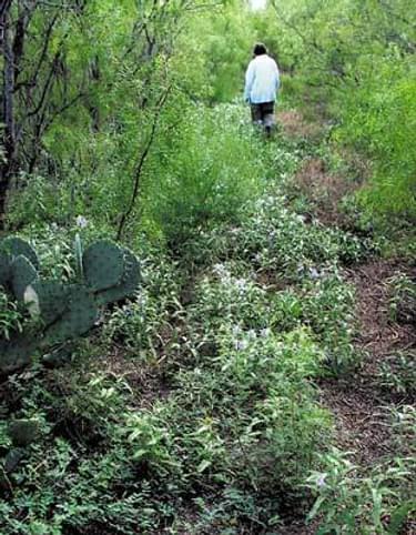
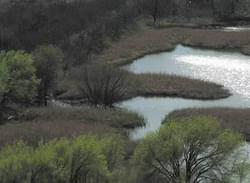
The 87-acre preserve, bordering Interstate 20, has been in City title since 1988, with a prior history of grazing and cropping. A rich growth of cottonwood, black willow, bigtooth maple, soapberry, and other species has matured in large arcs around the 26-acre playa, with prairie grasses and other field vegetation abundant in the open reaches.
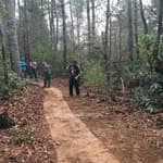
A track cut and kept by birders and other outdoor enthusiasts has been used by locals since the 1980's, and for years the Midland Naturalists have documented birdlife, odonates, reptiles, amphibians, and the occasional deer, bobcat, coyote, raccoon, and fox.
Midland's I-20 Playa Wildlife Preserve Master Plan 2007 was prepared by The Rivers Studio, LLC, Austin, Texas. Roy B. Mann, Project Director; Juanda Powell, GIS/Plan Illustrations; Peter Green, Architectural Rendering. The plan includes valuable species documentation by naturalists JoAnn and Don Merritt, Rose Marie Stortz, Bill Lupardus, and Burr Williams, the character, roles, and extent of access will change dramatically.
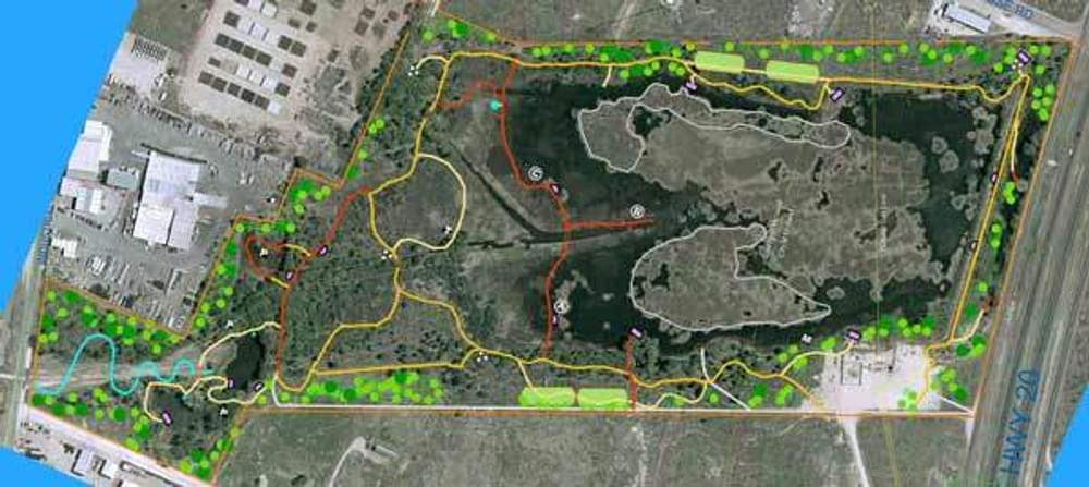
The foot track, which in places now struggles through thorny shrubs and vines and inundated flats, will change from a minimal path to a trail fit for both foot and wheelchair access. The track's existing length of 1.2 miles will nearly triple to a total of 3.4 miles of trails and boardwalks. While birding and habitat observation will remain primary objectives, jogging and hiking are encouraged, though biking will be excluded.
Trail surfacing material will be a mixture of stabilizing additives, caliche, and stone dust added to native sand. Concrete and asphalt will not be used, to conserve the preserve's natural character. Boardwalk construction, with habitat-protective helical piers, and the installation of four footbridges will permit traversing portions of the playa and enable routes through marshy edges. Widened sections of the boardwalks will allow classes to gather for observation and instruction at key points.
Stepdowns will make possible sampling of the water column and sediments in monitoring and research by visiting students, researchers, and management.
Observation decks at several points on the playa's shore and on the edges of one or more of the three ponds north of the playa, the legacy of old quarries, will be important points of resource interpretation and continuing habitat study. The approach trail from the nature center, partially elevated, will afford entering visitors broad views of the playa and its shore habitats.
A dozen roofed and walled bird blinds and four feeding stations will be designed. Approach walks from the main or loop trails will be surfaced with noise-absorbing mulch.
Two rafts will be moored in open playa waters, within easy viewing distances of the trails and observation decks, for waterfowl, turtles, amphibians, and odonates such as dragonflies and damselflies in both larval and adult stages.
Cattails have proliferated in the shallow playa waters, covering nearly three-quarters of the lake's surface and breaking up larger water expanses. Their increasing takeover and the surface's disruption have reduced both the playa's capacity to accommodate alighting waterfowl and its suitability for diving ducks such as ring-necked duck and canvasback, which require long open water reaches for take-off. Cattail eradication will reestablish open waters over two-thirds of the playa's total surface.
Removal of invasives and the planting of such native trees and shrubs as Netleaf Hackberry, Mohr Oak, Soapberry, and Evergreen Sumac, together with the seeding of key grasses, forbs, and vines, will fortify habitat nutritional value and shelter for wildlife while strengthening preserve scenic quality.
Trail interpretive signage will be designed with modest sizes and finishes to minimize intrusive effects.
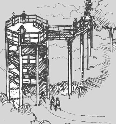
A hawk observation tower will provide excellent visual access to Osprey, Peregrine Falcon, Cooper's Hawk, and at least ten other raptors. Approach to the tower platform will be both by stairs and a wheelchair-accessible ramp. Two tree-canopy elevated walkways, totaling 1,200 feet in length, will be built in the deeper woodland. They will be the first of this trail type in West Texas.
Two butterfly and hummingbird habitats, excluding arbors and other devices common to urban settings, will feature trails winding through larval host and nectar-rich plants. On the preserve's northwest, a straight-line drainageway carrying storm runoff from residential and some commercial-industrial areas will be doubled in length but worked into tight meanders with new banks capable of high bio-infiltration for water quality management. A trail to the edges of the periodic stream will serve for monitoring and management as well as class fieldwork and general visitor access.
The preserve's introductory and interpretive backbone will be realized in the form of a major visitor facility at its edge — an educational, research, and management portal.
The facility, to be named the Jenna Welch Nature Study Center, will be designed with platinum LEED certification as its sustainability objective. State of the art exhibits, interactive educational displays, and bird tracking consoles will be among the center's core features. On the center's site perimeter, small replicas of preserve components— butterfly and hummingbird habitat, thicket, pond and marsh, and grassland— will be created to serve as supplements to the center's interior introductory displays orienting visitors to all aspects of the playa and its environment. Mark T. Wellen, AIA, partner in Rhotenberry Wellen Architects, conceived the center's development in the master planning process.
Completion of the preserve's principal trails and boardwalks is anticipated in early 2009. The nature center's first phase section is expected to open at that time or shortly afterwards.
Visit the I-20 Wildlife Preserve Website
Roy Mann is Founding Principal, The Rivers Studio, LLC, Park, Preserve, Trail, and Greenway Design/Landscape Architecture, Austin, Texas - (512) 343-9550 - [email protected].
Sustaining Wildlife With Recreation on Public Lands
posted Nov 25, 2023
Humans and wildlife interact in multifaceted ways on public lands with both positive and negative outcomes for each group. When managed well, wildlife-based tourism and other forms of recreation can benefit conservation goals.
Environmental Impacts of Winter Recreation
posted Nov 25, 2023
Regardless of our intentions, many species perceive humans as a threat and respond accordingly. In general, animals respond to threats by first increasing vigilance (time spent looking around versus foraging), and running away if the threat is perceived to be imminent.
posted Nov 24, 2023
Winter recreation is a rapidly growing activity, and advances in technology make it possible for increasing numbers of people to access remote backcountry terrain. Increased winter recreation may lead to more frequent conflict between recreationists, as well as greater potential disturbance to wildlife.
Guidelines for Managing and Restoring Natural Plant Communities along Trails and Waterways
posted Sep 18, 2023
These guidelines are designed to assist resource managers in conducting management activities that enhance the quality of natural plant communities, wildlife habitat, regional landscape integrity and visual quality, particularly as related to planning, development, and maintenance of trails, water trails, and water access sites.
1,004 views • posted 09/10/2018