City Of San José Trail Program
The purpose of this document is to provide the required tools for trail planners, designers, and contractors to deploy a cohesive trail signage program throughout the City of San José’s Trail Network.
by City of San Jose - Parks, Recreation, and Neighborhood Services
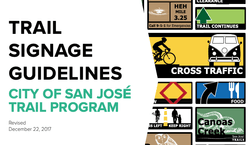
The purpose of this document is to provide the required tools for trail planners, designers, and contractors to deploy a cohesive trail signage program throughout the City of San José’s Trail Network.
The City seeks to develop a 100-mile Trail Network across 40 trail systems. At this time, 60 miles are developed and 85% are paved.
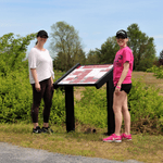
Throughout the development of the Trail Network, the City has consistently used best practices to support safer usage. Supporting this effort is the development of a comprehensive trail signage library with signs for common needs: regulatory, guidance, warning and custom messages such as wayfinding or points of interest. In addition, mileage markers track distances traveled and provide 911 operators the ability to quickly locate and dispatch assistance to trail users. A unique and consistent design approach will reinforce that the trails are within San José.
Attached document published December 2017

San José has hundreds of unique and breath-taking venues perfect for an outside day. Visit one of San José’s 200+ parks, hike along 60 miles of scenic trails or visit a regional park.
Visit City of San Jose - Parks, Recreation, and Neighborhood Services
iZone Imaging Brings Bugtopia to Life Through Signage
posted Jan 14, 2022
iZone Imaging’s High Pressure Laminate brings to life the interpretive signage throughout the Brawn Family Foundation Bugtopia Playground at the Calgary Zoo. The signs are eco-friendly and can withstand the high traffic interactive area over time. (Sponsored Content)
Signage Solutions for Every Trail System
posted Jun 11, 2021
Pannier is the leading manufacturer of signs, panels, exhibit bases, and frames. With a full line of exhibit bases, there is a product for every trail and wayside application.
posted May 7, 2021
This National Sign Guidebook presents information for planning, designing, fabricating, procuring, installing, and maintaining signs in a clear, complete, and user friendly format.
Smart Outdoor Inc. is Bringing Innovative Signs to Trails in New York and Beyond
posted Feb 23, 2021
Westchester County New York and Friends of Westchester County Parks, in collaboration with Westchester County Parks, announce collaboration with Smart Outdoor to enhance 34.6-mile running trail.
1,103 views • posted 05/06/2021