The El Camino Real de los Tejas National Historic Trail Association is working to create a multi-use trail that will connect two of the lone star state's largest cities, Austin and San Antonio.
by Taylor Goodrich, Communication and Media Specialist, American Trails
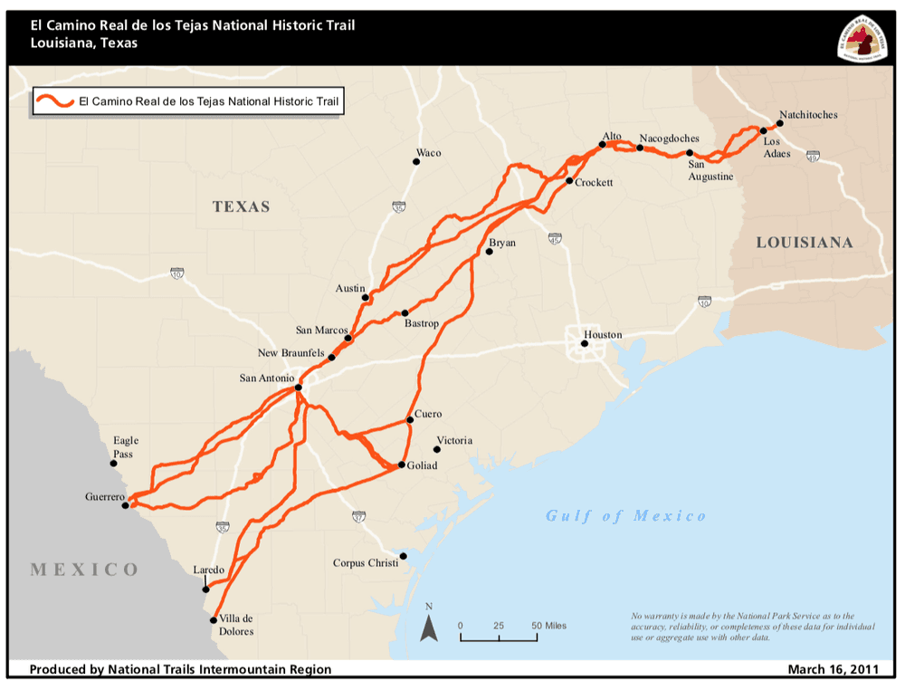
El Camino Real de los Tejas National Historic Trail is one of the most important trails you might have never heard of. The name might not exactly roll off the tongue, but people have been saying it for hundreds of years (although the National Historic Trail part was added much later). This well-traveled trail actually pre-dates both modern day Mexico and the United States as we know them. For hundreds of years before there were settlers, Native American tribes traveled these trails for trade, creating the foundation for what would later become the 2,500-mile road. In the late 1600s, when Spain still governed Mexico and much of what is now the United States was wild territory, the Spanish Governor at the time, Alonso de León, decided to officially forge a road from Mexico to modern day East Texas in order to keep the territory from the ever encroaching French explorers. In 1718 the city of San Antonio was founded along the road, and by 1821, when Mexico achieved independence from Spain, the road had been expanded and firmly established.
El Camino Real de los Tejas played an enormous role in Texas history. When Davy Crockett gave his famous quote, “You may all go to hell, and I will go to Texas.” El Camino Real de los Tejas is how he got there. Other famous Texans like Stephen F. Austin, Sam Houston, Jim Bowie, and thousands of migrants from the United States all traveled this road.
By 1915 Texas was a booming state, and many started to become concerned that the historical route would be lost if preservation steps weren’t taken. The Texas state legislature ordered an official survey to study the original route, and the Daughters of the American Revolution endeavored to place markers every five miles to make sure it would never be lost. Almost a century later, in 2004, President George W. Bush officially named the route a National Historic Trail. In 2007 the El Camino Real de los Tejas National Historic Trail Association was created to work managing the trail alongside the National Park Service.
Now the association wants this trail to make Texas history again by working to create a walkable path between Austin and San Antonio that mirrors the original route. Although this ambitious plan has a great deal of enthusiastic support, as with many things, trails in Texas are complicated. Unlike many states, especially in the west, Texas has almost no public land. Although roughly 28 percent of the United States is publicly owned federal land, in Texas that number is less than two percent.
This again goes back to Texas history. Unlike other states, when Texas joined the union it was its own country, and therefore had great bargaining power. Texas insisted on keeping its publicly owned land in state hands, rather than giving it to the United States government, and eventually sold almost all of that land to private owners. This has caused issues with lack of space for outdoor recreation, especially as the state population booms, growing at a rate of 12.6 percent since 2010.
So what does this mean for the creation of a walking path from San Antonio to Austin along the historical El Camino Real de los Tejas? Simply put, it means going slowly. Steven Gonzales, Executive Director of the association, estimates that this will be a 20-year project. Gonzales and the association have faced this problem before, and still come up with creative ways to grow and expand trails along the original El Camino Real de los Tejas route. One of the simplest solutions is to find trails that are already in place and may not even realize they also follow this historical route.
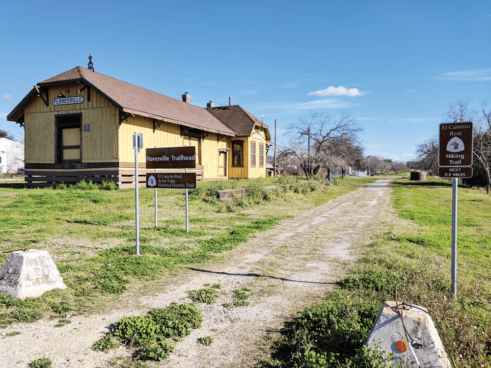
The association works to connect with those spaces, put up signs, and preserve any historical aspects on those trails. One example of this is the Medina River Greenway Trail in San Antonio. This seven-mile National Recreation Trail is the longest hikable section of El Camino Real de los Tejas. If one looks closely, U-shaped depressions, known as swales, can be seen on either side of the hiking trail.
Another solution the association has implemented is simply buying land that contains part of the historic trail route. This is what they did with an area known as Lobanillo Swales in Sabine County, Texas. The swales, caused by hundreds of years of wagon use over the land, are in high concentration in this area. The association, working with the National Park Service, used a money raising campaign to acquire the land tract, clean up the area, create a hiking trail, and install trail signs. That project was officially finished and opened to the public in 2018, with a ribbon cutting ceremony attended by over 140 people.
By continuing to pursue creative solutions, Gonzales believes they will be able to complete the route between two of Texas’s most populous cities. He even leaves open the possibility of a space for multiple trail user types, such as equestrians and cyclists in addition to hikers, being able to use at least parts of the trail.
The association is already working on the first leg of the trail, which will follow Onion Creek, just south of McKinney Falls State Park in Austin. Currently the association, alongside city and county representatives, has been scouting the site and using GIS technology to create a trail plan. If all goes according to plan, this will the very first stretch of a hike-able and bike-able Camino trail leading out of Austin and towards San Antonio.
Travel through the trail history and stay updated with the trail's progress at the El Camino Real de los Tejas National Historic Trail website.

Taylor Goodrich started with American Trails in January 2018 as Communication and Media Specialist. Taylor has worked with the National Recreation Trail (NRT) Ambassadors since the beginning of the program and has helped shape the program to where it is today. Taylor currently lives in Dallas, Texas, which is also where she grew up and where she attended the University of North Texas receiving her degree in History. While in college she started doing freelance work editing and writing, and also got into graphic design and discovered she loves the creativity and craft of digital arts. After college she traveled quite a bit, and lived in both the Pacific Northwest and in New Mexico, and while in both of those places took full advantage of what the outdoors had to offer. After moving back to Texas she started moving towards doing graphic design, social media, and communications work full time, and she has contracted with several companies from tech startups, to music festivals, to law firms, to grow their social media and digital communications presence. Taylor loves hiking and kayaking especially, and is glad to be working with an organization that fights for further accessibility and stewardship of our nation’s trails. She feels very lucky that in this position she will be able to use her professional skills and passion for something she is also very personally passionate about, and in helping to grow American Trails.
Contact: [email protected]
Blackstone River Bikeway, Rhode Island
posted Apr 14, 2024
The Blackstone River Bikeway takes you through the heart of the Blackstone Valley. Peddle past historic mills, workers housing, the Blackstone Canal, the Providence and Worcester Railroad, and the Blackstone River itself.
Twenty Mule Team Trail, California
posted Mar 17, 2024
For many people, nothing symbolizes Death Valley more than the famous Twenty Mule Teams.
Hillman Heritage Trail, Kentucky
posted Mar 17, 2024
Located in Hillman Ferry Campground, portions of the trail follow a long-abandoned road that once carried old cars, wagons, and horses to the Tennessee River at Hillman Ferry.
Desert Ecology Trail, Saguaro National Park, Arizona
posted Feb 19, 2024
Located in the Sonoran desert, this paved interpretative, signed trail gives an overview of the plants, animals, and weather encountered in the desert.
5,179 views • posted 10/14/2019