Trails LA County Mobile App
The story behind the development of LA Counties world-class trails mobile app and website covering 600+ parks, over 550 linear miles of trails, hundreds of points of interest.
by Ryan Branciforte, Co-Founder and CEO, OuterSpatial, Zachary T. Likins, Trail Planner, Los Angeles County Parks and Recreation Department, Michelle O'Connor, Trails Planning Section Head, Los Angeles County Parks and Recreation Department, Sheela Kleinknecht, Trail Planner, Los Angeles County Parks and Recreation, Dora Nuñez, Special Assistant to the Director & Head of Communications, Los Angeles County Parks and Recreation
When you think of outdoor recreation destinations, typically idyllic mountain towns like Aspen, Lake Tahoe or Bend come to mind. And no doubt, these are incredible places with wonderful outdoor adventure opportunities! But what about closer to home? An after-work mountain bike ride or trail run, a short overnight weekend backpack trip or something more low key like a nice flat trail to hike on with your kids for a few hours? For the more than 10 million residents of Los Angeles County, it turns out there is in fact a huge somewhat undiscovered gold mine of parks, trails and awe-inspiring outdoor adventures waiting right in their backyards...
It’s fortunate that all of these outdoor opportunities exist because according to LA County Parks and Recreation (DPR) and local, state and federal trail partners, they have noticed a dramatic increase in demand for recreational trails in the County, as more and more people look for ways to improve or maintain their health through physical activity. Los Angeles is not unique in this way as this trend is happening nationwide. In its 2014 “Outdoor Recreation Participation Report,” the Outdoor Foundation stated running/jogging/trails, bicycling and hiking ranked among the top five most popular outdoor activities among youth and young adults ages 6-24, and adults ages 25 and older. As the popularity and demand for trail usage increases, local parkland managers are facing significant challenges in providing residents with easily accessible trails-related information such as location, multi-use trail etiquette, closures, events, and trail user safety.
Ok, so where are all of these destinations? How many miles of trails? How do I get to them? Where do I park? Which ones can I ride my bike on or bring my dog? And once we know where they are, how do agencies effectively get all of the information about these destinations into the hands of locals and visitors?
Before diving into what is now a very popular mobile app and website destination, let’s unpack the complex outdoor landscape of Los Angeles County. We’re not talking about the diversity of the natural landscape such as the beaches, high desert and mountains of the region which are in fact amazing and diverse in the County, but rather the jurisdictional landscape.
Los Angeles is a massive county with an incredibly complex park and recreation ecosystem with organizations at all levels owning, managing and contributing to the rich outdoor recreation opportunities. This jurisdictional ecosystem includes over 80 cities, multiple federal agencies and state agencies as well as organizations working at the regional, county, and special district level. In addition, there is also a very strong contingent of nonprofit organizations actively involved in supporting these outdoor destinations.
In all, there is estimated to be over 2,000 miles of publicly accessible trails right in Los Angeles County. That’s like having ⅔ of the Pacific Crest Trail winding around the county, in and out of neighborhoods, along beaches and rivers and into the mountains. In fact, a nice stretch of the actual Pacific Crest Trail itself weaves its way through the Angeles National Forest within the County.
After researching the increased demand for local and accessible parks and trails and a strong desire for improved information about these outdoor opportunities it became clear that key partners would need to step up and take a leadership role in order to best serve the community. DPR, along with other key land managers in the county including California State Parks, the National Park Service, Mountains Restoration Trust, the Santa Monica Mountains Conservancy, the Mountains Recreation and Conservation Authority, and Catalina Island Conservancy comprise a partnership called ‘Trails LA County’ with a focus on better connecting people with the public trails across the County.
Trails LA County has developed two key resources that are available to the public, an officially County-sanctioned world-class trails mobile app and website.
Even just a few years ago, it was a huge technical lift to create a modern, feature-rich public facing smartphone app, a lift that was hard to justify for most public agencies, given the pace at which mobile technology is changing, the significant upfront cost and constant software updates. Fortunately for the Trails LA County partnership, that picture has changed substantially with a platform called OuterSpatial, which empowers organizations to easily publish their authoritative recreation information to visitors via web and mobile devices. The cloud-based service is designed specifically for park agencies, nonprofits and any visitor focused organization, allowing them to focus on the story they want to convey to their visitors without worrying about the technical complexities.
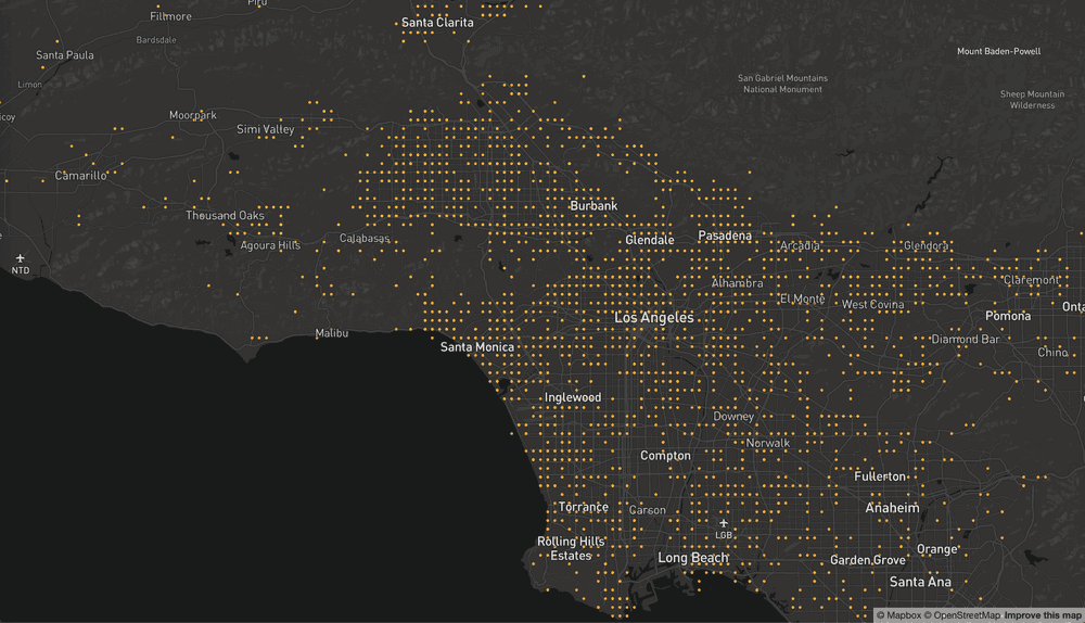
For visitors to experience all the County’s recreation data via the app and site in a consistent manner, the Trails LA County partners needed to align their data into a similar format. When the effort was initiated, each partner agency had their own internal data format and in every case it was different from every other agency. That end goal provided the incentive, while OuterSpatial provided the direction and tools. Leveraging an open trail data standard, OuterSpatial clearly laid out a data format that enables every agency’s data to be published in a consistent and standardized format to visitors. This work is still ongoing, but much progress has been made with over 550 miles of trails now available via the mobile app and website.
With high quality, consistent recreation data and a powerful platform to take care of the technical work, the partners were able to deploy the mobile app and start testing, but a critical component was still needed - content. Similar to any other park and recreation agency, all of the partners had wonderful content on their website, in brochures, in paper maps, signage, interpretive pamphlets, etc. The OuterSpatial platform provided an easy way to integrate all of that content into one place so it could be published effectively into the mobile app. There are ongoing training sessions with various staff and volunteers at the participating agencies that are helping to get more folks involved in publishing quality information to visitors including detailed park and trail descriptions, park brochures, high-quality photos. In addition, the partners are able to easily publish dynamic content such as closures, events, and real-time alerts that can be posted at any time.
A user-friendly “one-stop” resource: The app and website provide a comprehensive trails database covering 600+ parks, over 550 linear miles of trails, hundreds of points of interest including trailheads, parking lots, bathrooms, drinking water, scenic vistas and much more. Regardless of their interest visitors can now easily find and learn more about the wide range of available outdoor recreation options with inviting content such as beautiful photos, detailed descriptions, permitted uses, directions to trailheads, park maps and brochures, and time-sensitive alerts such as closures. Also, users can obtain extensive trail knowledge such as connectivity (e.g. how the 30-mile Schabarum-Skyline Trail in Covina connects the San Gabriel Mountains with the 35-mile San Gabriel River Trail that ends in Seal Beach), elevation, and the presence of natural wildlife, all of which gives them an accurate depiction of each trail’s individual character. As such, the app and website have become an invaluable one-stop online tool that users can rely upon for accurate, up-to-date and real-time information on trails and recreation information throughout the County.
As more folks use the app and website, more feedback is coming in and Trails LA County partners are listening. There are a number of new features on the roadmap including enhanced search and filter options, better social tools for sharing amongst visitors and agency staff, and improved data and content coverage. In addition, the partnership is working on expanding and bringing in every trail and land manager in the county including two key priority partners, the City of LA and the US Forest Service.
We would like to thank contributing authors:

Ryan Branciforte is the co-founder and CEO of OuterSpatial, a platform that empowers organizations to connect people to the outdoors. During his 20+ year career working in the public, nonprofit and private sector, Ryan has always had a deep passion for using technology to do good conservation work and get people outside.
Contact: [email protected]

Zachary T. Likins is a Trail Planner with Los Angeles County Parks and Recreation. He has over 7 years of professional experience in a variety of progressively responsible planning roles, including expertise in long-range planning, design review, project management and land acquisition.
Contact: [email protected]

Michelle O’Connor oversees Trails Planning for the Los Angeles County Department of Parks and Recreation Planning & Development Agency. She has more than 13 years of public sector experience with a focus on park planning and project management. Michelle has played a key role in advancing the work of the Trails Planning team over the past several years, and during her career in Planning she has served as the Project Manager for variety of interesting and complex projects such as the Puente Hills Landfill Park Master Plan, the North Las Vegas Citywide Trails & Bikeways Master Plan, the Kiel Ranch Historic Park Comprehensive Preservation and Development Plan, and the Culver City Zoning Code Update.
Contact: [email protected]

Sheela Kleinknecht is a Trail Planner with Los Angeles County Parks and Recreation

Dora Nuñez is the Special Assistant to the Director & Head of Communications, Los Angeles County Parks and Recreation
posted Apr 17, 2024
This report summarizes guidance and best practices to create safer bicycle facilities and connect them into networks that allow more people to safely bike to more places within and throughout communities.
Setting Speed Limits for Health and Safety
posted Apr 17, 2024
This mini-report on setting speed limits shows the current framework for speed limit policies through a review of state laws that set speed limits.
posted Nov 14, 2023
These case studies reveal a number of lessons learned that will be valuable in future winter travel management planning efforts.
TRAILS SAFE PASSING PLAN: STOP, SPEAK, and STAND BACK
posted Feb 14, 2023
Horses are prey animals and naturally can be afraid of unfamiliar people and objects. Horses have natural "flight“ survival instincts and prefer to move their feet towards an exit route. Therefore, people with horses should pass at a walk while other trail users remain STOPPED until passed.
2,028 views • posted 07/31/2019