
This award recognizes a trail-related product, process, or service that has significantly met a need, addressed an issue, or increased efficiency in trail design, development, or maintenance.
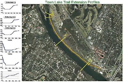
Town Lake Trail Extension aerial map
City of Austin for their use of multiple technologies including GPS, GIS, print and Internet to increase efficiency in trail design, development, or maintenance throughout the City of Austin.
The combination of GPS, GIS, print, and Internet technologies has greatly improved the efficiency and timeliness in the dispersal of trail information. The City of Austin's Parks and Recreation Department has utilized this technology and over the past two years has mastered a system of information gathering, assessment, and delivery that allows for much greater accuracy and usefulness of trail maps for the City's trail system.
One example of how this technology has been used in Austin is seen in the Barton Creek Greenway Kiosk map. This map uses 2D and 3D imagery to help trail users visualize the conditions they might come across on long routes. Another example is the map for Emma Long Park, this map provides an important safety feature on this motorbike trail by indicating the location of the EMS/911 call boxes.
The City of Austin has also utilized this technology to advocate for future trail development. Presentation boards containing maps that provide an aerial view of the area under discussion for the Town Lake Extension Trail, aid in the visualization of key aspects of the argument in favor of developing this trail extension.
2015: Single Track, LLC
2013: Gerry Wilbour and the Northwest Trails Crew
2010: City of San Jose, Department of Parks, Recreation & Neighborhood Services
2008: Chris McNeil
2006: Cedar Valley Trails 911 Signs Project, Iowa
523 views • posted 12/25/2017


