This award recognizes a trail-related product, process, or service that has significantly met a need, addressed an issue, or increased efficiency in trail design, development, or maintenance.
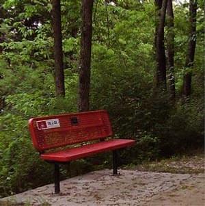
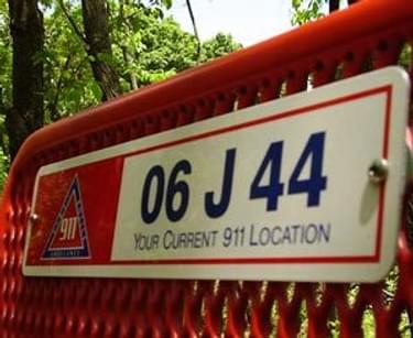
Benches are GPS location markers on the Cedar Valley Trail System
The objective of the signing project was to design a comprehensive method to georeference trail locations for emergency response and asset management purposes.
The Cedar Valley Trail System and the Cedar Valley Nature Trail encompass 95 miles of paved trail within Black Hawk County, Iowa. As trail use and the trail system expanded, coupled with the secluded nature of the trails, an improved means of communicating trail location was needed for emergency response situations. There are over 1700 trailside features, including signs, benches, and shelters.
The Trail crosses through many jurisdictions (Cedar Falls, Evansdale, Hudson, Waterloo, BHC, and the State of Iowa). The Iowa Northland Regional Council of Governments (INRCOG) coordinates transportation planning, grant writing, and Trail mapping. Thus, rather than each jurisdiction devising an approach to Trail asset data collection, a common method useful to all the jurisdictions to provide uniformity was needed.
The Cedar Valley Trails 911 Signs Project represents the culmination of a county-wide effort to address this need.
The project utilizes state-of-the-art geographic information systems (GIS), global positioning system (GPS), and computer-aided emergency dispatch (CAD). When a 911 sign ID code is entered by a dispatcher into the CAD system, the corresponding trails segment is automatically centered in the CAD map view.
This visualization helps dispatchers guide the appropriate responders to the emergency site and displays a written description that details the incident location, including which streets and from what direction an emergency vehicle can gain access to the trail, along with any travel restrictions such as narrow footbridges impassable by ambulance.
It is a practical solution to location communication in emergency situations and serves as an asset inventory of all features along this the system.
2015: Single Track, LLC
2013: Gerry Wilbour and the Northwest Trails Crew
2010: City of San Jose, Department of Parks, Recreation & Neighborhood Services
2008: Chris McNeil
2004: City of Austin
631 views • posted 12/25/2017