
Education and Communication
Blue Tree Trail System - Nevada
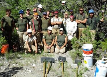
Volunteers from Backcountry Horsemen of Nevada
This trail system adds 50 miles of quality trails that provide sustainability and protection to important cultural and natural resources while providing a safer, high quality recreation opportunity for a variety of user-groups.
This is the first trail system on the Spring Mountains National Recreation Area (SMNRA) that encourages shared use and addressed the needs identified by by local equestrians and mountain bikers with the request to formally designate and maintain a grouping of game and user-worn paths. The majority of designated trails at that time were off limits to mountain bikes because the trails entered designated wilderness and were all of an out-and-back, uphill-downhill nature.
Early in 2005 the Forest Service obtained the necessary funding to perform an environmental assessment through the Southern Nevada Public Lands Management Act (SNPLMA). The analysis revealed cultural sites, sensitive endemic plants, wildlife concerns and many sections of trail that were poorly aligned and eroding as well as causing impacts to plants, wildlife and cultural sites.
No money had been provided for implementation however once the analysis was complete and the decision was signed; and this is where the Recreational Trail Program (RTP) made our planning and the dreams of trail users a reality. This is a 50-mile nonmotorized trail system used by hikers, equestrians, mountain bikers and trail runners.
Maintenance and rehabilitation
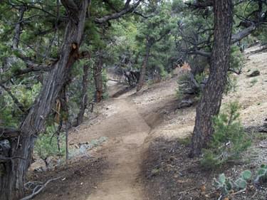
Approximately 17 miles of new trail location and construction were accomplished through this grant. This action improved the sustainability of the trails, provided a safer, higher quality recreation opportunity for visitors as the trails were undefined and severely eroded in many locations. The realignments provided protection to riparian areas, soils, and wildlife. For example; at a trio of springs the trail passed through a spring site and close to a nesting site for goshawks. The majority of this trail was also close to cultural sites and was badly eroded.
In this case the trail was re-routed below the spring to a site where runoff provided water for stock but encouraged users to bypass the riparian area via the new route which was pulled uphill away from all three springs, the cultural sites and the goshawk nesting area. Project dollars were also utilized for biological monitoring of sensitive species and for migratory bird surveys to identify nesting birds sites.
The remainder of the trail system was maintained to Forest Service Standards as needed. The trails were made safer by removing rutted sections and allowing visitors to easily identify and follow the routes. All trails that were replaced by new construction were closed and restored allowing them to return to natural conditions.
Construction and design
Fifty miles of trail were surveyed during the analysis and 17 miles were relocated to sustainable durable surfaces. Every effort was made to build these trails to provide the highest quality recreation opportunity. These trails are fun! They can be enjoyed by all non-motorized user groups including trail runners.
One trail runner compared them to running in a forested video game. They are not all climbing to a destination and then descending to the trailhead. Other trail building techniques like using scare-rocks to direct use patterns to the most durable surfaces and pinch-points to slow users down in some areas, like just before an upcoming tail junction were used to increase user safety.
Education and communication
The Forest Service partnered with the Las Vegas Clark County Health District with the development of their trail website and smart phone app. These programs include all trail through-out Clark County and allow visitors to find recreation opportunities to meet their needs and encourage them to get outdoors and get active. The Blue Tree Trail system is featured on this program.
Multiple-use management and corridor sharing
These trails are shared by mountain bikers, equestrians, hikers and trail runners. Previous to the designation of this trail system the trails on the SMNRA were primarily hiker dominated. Very limited opportunities for mountain bikers existed and equestrians wanted loop trails with access to water that were not as steep and in some cases very limited distance.
This is the first trail system on the SMNRA that encourages shared use and addressed the needed identified by user-groups. The location of these trails also addressed a key issue for the Forest Service to provide opportunities that dispersed use and encouraged recreation in lower elevation settings.
Youth Conservation/Service Corps and community outreach
The work accomplished through the RTP Grant was performed almost exclusively by youth corps. The Great Basin Institute (GBI) was our main project partner. They provided a total match nearly $29,000. Trail Crews from GBI constructed the re-routes and closed and restored sections that were replaced. Total federal match was nearly $102,000 and came primarily from the Spring Mountains Youth Camp (SMYC).
This camp is part of the Clark County Juvenile Justice Program and provides education and work experiences for youth offenders. The Forest Service puts $25,000 annually toward this program, most of the money going to the youth for work performed and used as restitution. Clark County provided in-kind contributions as part of the total match as well. Total match for this grant was nearly $130,000.
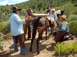
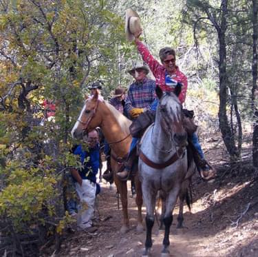
Another significant project partner was the Bristlecone Chapter of the Backcountry Horsemen of Nevada. This group helped with trail maintenance, installed all of the signage and provided volunteer pack stock support for all of the trail crews both GBI and SMYC. Their volunteer service provided a portion of the federal match. This group also works with the Future Farmers of America from a local high school. These students learn horsemanship, packing and trail work. Other local volunteer groups, individuals and events also helped with the project including mountain bikers, hikers, youth service organizations, REI, Keanne/Zappos and group events like National Trails Day.
Some of these groups are continuing to support the trail system by performing trail patrols to check signage, trail conditions and provide information to other trail visitors.
Summary
This trail system adds 50 miles of quality trails that provide sustainability and protection to important cultural and natural resources while providing a safer, high quality recreation opportunity for a variety of user-groups. It brought together a wide array of interest groups who pulled together to support a common vision and bring it to a reality on the ground, learning new skills along the way.
More winners of this award
2023: Avalanche Beacon Checking Station Signs
2023: Sensible, Courteous, Off-Road, Enthusiasts / SCORE
2021: Sign Language Saturday
2020: Nevada’s Outdoor School’s Outdoor Ethics Program
2019: Gallatin National Forest Avalanche Center (GNFAC) – Montana
2018: Spearhead Trails - Virginia
2017: Woodruff Greenway Trail - South Carolina
2016: Great Trails: Providing Quality OHV Trails and Experiences Guidebook (Nationwide)
2014: Missouri State Parks Trail Book
2013: School Messaging Program - Minnesota
2012: Intertwine Alliance Bi-State Regional Trails Website - Oregon and Washingston
2011: Shadow Mountain Trail System - Wyoming
2010: Coalition of Recreational Trail Users Educational Trailer - Minnesota
2009: Giant's Stairs Trail Project - Maine
2008: Recreation Maps and Educational Materials - Wyoming
2007: Trail Planning, Design & Development Guidelines Book - Minnesota
2006: Washington & Old Dominion Railroad Regional Park - Virginia
2005: North Slope Trailer Project - Wyoming
2004: Western Wyoming Avalanche Education - Wyoming
2004: Sensible, Courteous Off Road Enthusiasts (SCORE) - Pennsylvania
2003: Green Ridge State Forest & Rocky Gap State Park Trail - Maryland