Prepared by Richard D. Koehler and Janet M. Sowers, William Lettis & Associates, Inc. for the City of Oakland.
An Assessment of Trails, Watercourses, Soils, and Redwood Forest Health in Joaquin Miller Park, Oakland, California.
This report summarizes the methodology and results of an assessment of the current condition of trails, watercourses, soils, and redwood forest within Joaquin Miller Park, Oakland, California. The purpose of the investigation was to provide baseline data on sediment sources and erosion associated with the trail network and watercourses and to determine the health of the redwood forest within the park. The investigation was focused on 11 specific areas of concern identified by the City of Oakland.
An assessment of additional problem areas identified during field reconnaissance is also included. The motivation for this study arises from concerns over the perceived negative impact of increased recreational use in the park. The baseline data produced in this report will provide a framework for understanding the impacts of erosion and sedimentation on park resources and help land use planners evaluate watershed management plans.
Several factors contribute to the erosion of forest trails. Fluvial erosion is a major natural process that acts on the landscape in the presence or absence of trails. It results from the concentration of surface water runoff and is often enhanced by groundwater seepage. Sheetwash, rilling, gullying, streambank erosion, and bed scour are all examples of fluvial erosion processes. When trails are constructed without adequate provision for surface and groundwater water drainage, trails become subject to fluvial erosion. Mass wasting is another natural process that can contribute to the erosion of trails.
Landslides and streambank failures are examples that can be found in Joaquin Miller Park. Although natural, these processes can be exacerbated by human activities. Recreational use results in two types of human induced processes which can cause or exacerbate trail erosion. Abrasion, in which soil is physically loosened and moved downhill or to the side by feet, tires, or hooves, can move significant amounts of soil. Evidence of such movement can be seen in the form of steps, grooves, troughs, and skids on hillslopes or on trails. These features can then enhance fluvial erosion by providing pathways for concentrated water flow. On some trails the cumulative effects of trail use can lower the trail surface and create an outside berm. Outside berms prevent surface water from exiting the trail and encourage fluvial erosion by forcing surface flow downhill.
Trampling is a second process caused by recreational use. Trampling by itself does not erode the soil; rather it destroys the vegetation and compacts the soil. Soil compaction, in turn, makes the soil less permeable resulting in greater runoff and subsequent fluvial erosion, and it prevents the penetration of roots and reestablishment of vegetation.
Other studies have documented the effects of recreational land use on trail erosion (eg. Seney and Wilson, 1989; Barbera et al., 1986; Kuss, 1983; Summer, 1980; Weaver and Dale, 1978). These studies all agree that recreational land use tends to increase erosion rates on trails due to destruction of vegetation, compaction of soil, and loosening of the surface layer of soil. The amount of erosion is dependent on the type of use, intensity, and the length of time of use.
The effectiveness of the above processes in degrading the trails is governed in large part by the trail conditions. Trail grade, alignment, drainage, tread material characteristics (specifically infiltration properties and erodability), trailside vegetation, and local geomorphology all make the trail more or less susceptible to erosion. For example, trails that have gentle gradients and hard trail tread materials (i.e. bedrock) are relatively resistant to erosion. In contrast, fluvial or recreational erosion can cause large volumes of erosion on trails that have steep gradients and soft trail tread materials (i.e. forest soil). Thick soil cover and vegetation in close proximity to a trail can absorb surface water and limit fluvial erosion. Properly located drainage structures can also limit fluvial erosion by diverting surface water off the trail. Decayed or plugged culverts can increase fluvial erosion by causing streams to overtop their banks and flow on the trail surface.
Joaquin Miller Park is located in Alameda County on the southwestern slope of the East Bay Hills between Highway 13 and Skyline Boulevard. The City of Oakland owns and operates the park. Numerous small creeks drain the upper reaches of the park into Palo Seco Creek, a major tributary to Sausal Creek. The rugged upper section ofthe park is underlain by Upper Cretaceous Oakland Conglomerate and Joaquin Miller Formation bedrock (Radbruch, 1969). The Oakland Conglomerate underlies the flat ridgetops located on the northern edge of the park and is composed of pebble and cobble (up to 8 inches in diameter) conglomerate in a yellowish-brown, weathered sandstone matrix. The Joaquin Miller Formation underlies the steep sided ridges and canyons in the middle of the park and is composed of thinly bedded to massive (up to 10 feet thick) beds of yellowish-brown sandstone, shale, and minor conglomerate.
The lower section of the park is characterized by gentle topography and is separated from the steep upper section of the park by the northwest-trending Chabot fault located in the vicinity of the park visitor center and Palo Seco Creek. The lower section of the park is underlain by Upper Jurassic massive shale and interbedded sandstone of the Knoxville Formation, Upper Jurassic to Cretaceous greenstone and serpentine of the Franciscan Formation, and Pliocene Leona Rhyolite bedrock (Radbruch, 1969). The southwestern border of the park is less than a quarter mile from the active, northwest-trending Hayward fault. The rock formations in the lower section of the park also strike to the northwest.
Much of the Oakland Hills, including the area of Joaquin Miller Park was extensively logged of its old growth redwood forest between the years of approximately 1850 and 1860. In 1886, the writer and poet Joaquin Miller built a cabin (named “The Hights”) in the location of the present day park. Joaquin Miller was dedicated to preserving the acres surrounding his home and planted more than 75,000 Monterey pine, Monterey cypress, sequoia, olive, and eucalyptus trees. After his death, the City of Oakland purchased 68 acres from the estate of Joaquin Miller. In 1928 the Save the Redwoods League purchased additional acreage, bringing the park total to approximately 425 acres.
Today the park offers scenic trails and a wealth of recreational (e.g., hiking, horseback riding, mountain biking), educational, and cultural opportunities. Recreational use of the park has increased steadily over the past few decades, and recently there has been public concern over the health of the redwood forest, erosion of the trail network, and downstream sedimentation in Palo Seco Creek and Sausal Creek (Tony Acosta, personal communication, 2000).
William Lettis & Associates conducted field assessments of the 11 areas of concern identified by the City of Oakland (Areas A through K on Figure 1) in order to characterize soils and document the nature and extent of erosion on the trails and watercourses in Joaquin Miller Park. Natural Resources Management Corporation conducted field surveys to assess the general health of the redwood forest and understory vegetation. In particular, their surveys were designed to assess whether the existing trail use is having a detrimental effect on tree health and growth.
The general characteristics of soils in the redwood forest in Joaquin Miller Park were determined by describing soils from four hand-auger holes. A 1.5 meter long hand auger was used to obtain samples of the soils for inspection. In order to document the variability of soils existing in different topographic locations, we described one soil in a valley bottom, two on a ridgetop, and one on the flank of the ridge. Soils were described according to the methods of the Soil Survey Division Staff (1993) and Birkeland et al. (1991) and include horizon thickness, nature of horizon boundaries, color, percent gravel, estimated clay content, texture, structure, wet and moist consistence, and the abundance of roots and pores.
Sources of erosion and sediment production from trails were identified by walking the trail network. At each significant erosion feature observed on the trail system (features numbered 1-27 on Figure 1 and Table 1), qualitative and quantitative baseline erosion data were recorded on field data sheets (located in Appendix 1). Erosion data collected included location of feature, nature of feature, volume of past erosion, potential for future erosion (low, moderate, high), and priority for repair (low, moderate, high). Individual erosion features were photographed and their locations plotted on the Joaquin Miller Park trail map. These data are attached to the corresponding field data sheet. The volume of erosion that has occurred at each site was calculated by measuring the length, width, and depth of the feature with a tape measure. Observations bearing on possible causes of each erosion feature were recorded in a field notebook and summarized on the field data sheet.
The current condition of the watercourses within Joaquin Miller Park was evaluated by walking selected streams and making observations and measurements at trail/stream crossings and along stream banks. The watercourses targeted in this study included; (1) the main channel of Palo Seco Creek; (2) the major tributary of Palo Seco Creek along Cinderella Trail; and (3) the four prominent tributaries that cross the Sequoia Bayview Trail and drain the steep redwood forest in the southern portion of the park. The types of baseline erosion data collected on these watercourses are similar to the baseline erosion data collected at trail erosion sites. The baseline erosion data was used to prioritize individual erosion features for mitigation and future study.
The general health of the redwood forest overstory and understory was assessed by field surveys around the trail areas within the areas of concern. The overstory surveys consisted of two types of survey methods. First, a general random ocular survey was conducted to assess the overall health of the trees and to identify areas that may warrant additional investigation. Observations were made for tree vigor, mechanical damage, and tree pathogens. Second, specific trees were selected to sample for age, growth rates, and defect observations. Selected redwood trees were sampled for growth rates by taking sample cores with an increment borer and measuring radial growth. Understory surveys were performed to identify native and non-native plant species and to assess traffic impacts on the health of the vegetation.
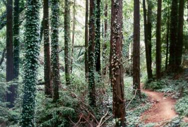
Trails Sediment sources and erosion problems were documented along the trail network and watercourses in Joaquin Miller Park, specifically in 11 areas of concern identified by the City of Oakland, labeled A through K on Figure 1. Trails in these areas of concern are cut into a variety of different soil and rock conditions, and they range from flat to steep. Additionally, the trails traverse several different ecosystems, mainly redwood forest, oak woodland forest, and grassland. Trails in the more popular areas of the park have experienced more use than trails in less popular areas. "Bootleg trails" (trails created by users and not maintained by the park) and trails not included in the City of Oakland's specific areas of concern also were observed.
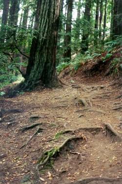
The majority of the specified trails have experienced a considerable amount of use over the years, and as a consequence are well compacted. Many of these trails were constructed with adequate grade, alinement, and width characteristics. Because of tight compaction and good construction techniques, trails that have gentle gradients, and/or bedrock tread material were observed to be relatively resistant to erosion and have few erosion problems. Some trails, however, were constructed with poor grade and alinement characteristics on areas with soft soils. Rill and gully networks were observed on steeper trails with the same degree of compaction as shallow gradient trails.
Rills are common on steep trails throughout the park and are usually associated with improper drainage or drainage structures that have not been maintained. Rills form in places where surface runoff cannot exit off the trail, forcing the water to concentrate in low spots and flow down the trail. After the water erodes through the compacted surface layer, rill development accelerates. Rills that are left untreated for many years develop into rill networks, and in extreme cases become gullies. Local shallow bedrock conditions on steep and flat trails can contribute to their relative stability and resistance to rill development.
The erosional impacts identified during the field inventory were related to natural processes including slope instability, rainfall, and surface runoff, as well as recreational trail use including running and hiking, horseback riding, and bicycle riding. The total volume of past erosion that has occurred at each feature observed on the trails and watercourses is presented in Table 1. Approximately 59% of the total past erosion is attributed to naturally occurring bank failures and landslides observed along watercourses. This volume is considered a minimum because the volume of older healed bank failures and inner gorge landslides is difficult to calculate. The most common erosion feature in Joaquin Miller Park is rills created by surface runoff. This erosion, however represents only 7% of the total past volume of erosion.
Surface water runoff was determined to be the dominant erosion mechanism acting on the park trails. Erosion generated by horses, bicycles, and hikers was determined to be a minor erosion mechanism on established park trails. However, recreational use was determined to be major source of soil erosion on "bootleg" trails. We noted many off trail hiking and biking tracks throughout the park. Hiking tracks were identified based on trampled plants, footprints, and the presence of step holds. Bicycle tracks were identified based on skid tracks through soft soils and narrow grooves. We observed that these "bootleg" trails often break through the soil O horizons exposing the erodible A horizons. With continued use, bicycle tracks begin to remove A horizon material, forming a groove that becomes progressively deeper. Hiking tracks expose and compact the A horizons and trample vegetation, making it difficult or impossible for the trail tread to naturally recover. Because the most fertile layer has been stripped, roots may have difficulty penetrating the compacted soil, and the trail may be eroding too rapidly for new plants to become established. Many of these trails, both hiking and bicycle, are oriented directly downhill, facilitating the rapid flow of water that deepens the tracks. One particularly bad "bootleg" trail begins near the DAR monument on the Big Trees Trail and ends near the junction of Fern Trail and the Sequoia Bayview Trail. Bicycle traffic on this trail has eroded a deep rill in the soft redwood soil.
The watercourses in Joaquin Miller park were found to be in excellent condition. The four main creeks that drain the redwood forest in the southern portion of the park have steep channel gradients, deep v-shaped canyons, and often flow on bedrock. These channels have occasional bank failures related to saturated slopes and high stream flow. The stream that parallels the Cinderella Trail upstream of the junction with Sunset Trail has steep valley walls and has had natural bank failures caused by high flows. Upstream of erosion feature 10, the creek has a shallower gradient, thick brush, and no landslide or bank failure problems. We noted no major effect of recreational land use on these channels.
The fine texture and friable nature of these soils suggests they will be highly susceptible to erosion if exposed. At present, the O horizon with its dense root mat provides a protective skin for the soft soil underneath. Providing additional protection are the permeable nature of the surface, which promotes infiltration rather than runoff, and the presence of the redwood canopy, which may diffuse the impact of raindrops. However, if the O horizon were removed, soil loss could be rapid and extensive. The O horizons are also important in themselves. They hold a significant percentage of the rootmass of the redwood trees and they cycle nutrients from the decomposition of the leaf litter back into the redwood roots. Every precaution should be taken to preserve the O horizons of these
soils.
No extraordinary conditions were observed with regard to tree vigor, mechanical damage, and tree pathogens. No areas showed signs of declining vigor.
Very little mechanical damage was observed in the Park. Even broken tree tops, occurring from wind stress, were found to be less common than expected. The one exception that was observed, albeit not a serious condition, was that some trees have experienced some animal rub damage. A few redwood trees along the Big Trees Trail between Areas “I” and “J” lying just west of Skyline Boulevard have scuffed bark at two to six feet above ground level. This condition is not uncommon in forests where bear and often elk will return to a favorite tree to scratch themselves. The result is often that most of the bark gets rubbed off, and damage occurs to the underlying cambium layer. Trees do not usually die from this; however, their growth is often retarded. The trees observed in the Park had very light damage that was likely caused by horses hobbled in this area by equestrian users. This situation should be monitored in the future to insure significant damage does not occur.
There are several internal and external factors contributing to invasive weed infestations, which threaten the diversity and existence of the native plants. The external factors are the surrounding urban development and disturbance, which introduce and spread exotic plants. The internal factors are traffic impacts (trail and off-trail) that destroy the native plants and disturb and compact the soil. These traffic impacts allow an opportunity for the invasive and exotic plants to colonize the edges of these exposed trail corridors, as well as provide a method of seed dispersal for these plants via shoes, hooves, or tires. The majority of exotic and garden plants coexist with native species and are not ecologically harmful. However a small number of exotic plants are ecologically devastating. Two of the invasive plants, English ivy and English holly, are shade-tolerant species that aggressively displace native plants in the closed-canopied portions of the redwood forest. In particular, English ivy has a distinct impact in the riparian corridor.
General recommendations are presented below to reduce the impact of fluvial and recreation-related erosion on the trail system in Joaquin Miller Park. We note that several established trails have excessively steep gradients and poor alignment, making them both challenging for users and susceptible to erosion. Examples of such trails are the Cinderella Trail, Upper Palos Colorados Trail and the Fern Trail. A long term goal, should funding become available, might be to rebuild these trails incorporating switchbacks to reduce gradient and wooden or stone steps where switchbacks are impractical. Possible mitigation measures to reduce fluvial erosion include:
To reduce recreation-related erosion on the trail system, we recommend that off trail or "bootleg" tracks be physically blocked off and signed. The split rail fences that were recently installed on the Sequoia Bayview Trail are an example of an effective barrier. These fences should be maintained regularly, and their effectiveness monitored. Other types of barriers include placement of large rocks, piles of debris, and large logs. All such barriers should be attractive and be seen to fit in with the natural environment. They should divert attention away from the tracks and onto the main trail. Tracks should be blocked off at both uphill and downhill ends. Restoration activities may help to reverse some of the impacts of these trails.
We suggest the addition of signage to the new split rail fences. The text might read:
Off-trail hiking and bicycling damages
delicate forest plants and soils
and is prohibited by law.
STAY ON THE TRAIL
The recommendations described above were determined by reviewing trail and forest road maintenance literature and represent, in the authors opinion, a viable course of action to reduce future erosion of the trails. There are many alternative methods available to treat erosion problems on forest trails. Trail construction and maintenance reference materials are available from a variety of organizations including:
Erosion from forest roads maintained for timber harvest in the Pacific Northwest has been intensely studied in recent decades due to sedimentation problems related to fishhabitat, (Elliot and Tysdal, 1999, Weaver et al., 1987, Reid and Dunne, 1984, Megahanand Kidd, 1972). Many mitigation measures have been well tested, documented, and evaluated in erosion control and prevention projects on steep forested lands, and havebeen shown to be effective in reducing sediment yield from managed forest roads, (Harrand Nichols, 1993, Weaver, 1998, Pacific Watershed Associates, 1994c). These proven techniques used for erosion assessment on forest roads include a field inventory oferosion and mitigation recommendations designed to minimize or eliminate the erosion.
These recommendations usually entail a physical modification of the road surface (i.e.diversion ditches and/or regrading), in order to divert surface water runoff away from the road, minimizing future erosion. Many parallels exist between timber harvest roads and the trails in Joaquin Miller Park, such as compaction due to land use, loosening of surface soils, and drainage problems. Because of these similarities, techniques used to reduce erosion on forest roads may be applied to recreational trails.
We recommend that the City of Oakland, Office of Parks and Recreation review the available literature and consult related organizations in order to determine the most cost effective erosion mitigation for Joaquin Miller Park. We believe that park dollars would best be spent on the installation and maintenance of erosion control structures on the steeper trails in the park where erosion impacts are the worst.
Several recommendations are presented below to reduce traffic and invasive weed impacts to the redwood forest understory. These recommended measures involve a combination of protection and restoration of the native vegetation, and weed abatement. Adoption of these recommendations can be done over a short or long time period, as logistics allow (such as funds and labor). The most important step is to initiate these recommendations at some level, because every effort can have cumulative effects and substantial results. An example is the volunteer restoration program across the San Francisco Bay at the Golden Gate National Recreation Area that has made a tremendous difference over time in several degraded open areas. The initiation of these recommendations should first involve the identification and prioritization of the problem areas and then set the objectives and goals for these areas. The recommendations are:
The traffic barriers are an effective method to divert and limit off trail traffic. These diversions help to protect the existing vegetation and/or promote revegetation of the understory, as well as minimize off-trail erosion and channeling of surface water run-off. Presently there are several short lengths of split rail fencing that have been installed along portions of the trails, which have successfully diverted off-trail traffic. There are several areas of intact native vegetation along the ridgeline associated with the Big Trees trail that would be good candidates for diversion structures, such as the split rail fencing. The protection of intact understory vegetation and soil in high traffic areas not only maintains native species presence, but serves as a seed source of regionally appropriate native plants that can be utilized for natural expansion or future restoration projects.
An invasive weed program is essential in maintaining the health, diversity, and esthetics of the redwood forest understory. Invasive weed infestations are indicators of a degraded habitat (disturbed and low functioning). Any effort toward invasive weed abatement is beneficial and can utilize community, park, city, state, and/or federal resources (such as California Exotic Pest Plant Council, University of California Cooperative Extension Services, California Conservation Corps, community service work groups, local chapter of the California Native Plant Society, and community/school volunteers). An example of a good initial effort would be to girdle the English ivy on the redwoods by cutting through the stems of the ivy around the base of the trees (being careful not to harm the trees). The ivy will eventually kill the trees and the aerial portions of ivy are the fertile shoots that produce the fruit, which is dispersed by birds. There has been a recent federal mandate to address weed issues (Presidential Executive Order on Invasive Weeds, February 1999) and to encourage planning and action at local, tribal, state, regional, and ecosystem levels, which is generating funds such as grant monies.
The overstory in the redwood forest appears in good health (this issue has been further addressed in this report), however the understory does appear to be the most affected by general trail traffic. One of the goals of the park users and staff should be to join together to abate the degradation of this valuable community and environmental resource through protection and restoration the of the redwood forest understory vegetation.
REFERENCES
Acosta, T., 2000, personal communication, City of Oakland, Office of Parks and
Recreation, Director.
Barbera, F., B. Hopp, C. Crockett, L. Strom-Berg, 1986, Synopsis of Historical,
Environmental, and Sociological Considerations Related to Mountain Bicycle Use
in Park Trail Settings, Submitted to the Off-Road Bicycle Committee of the Santa
Clara County Parks and Recreation Department.
Birkeland, P.W., Machette, M.N., and Haller, KM., 1991, Soils as a tool for applied
Quaternary geology: Utah Geological and Mineral Survey, Miscellaneous
Publication 91-3, 63 p.
Elliot, W.J. and L.M. Tysdal, 1999, Understanding and Reducing Erosion From Insloping
Roads, Journal of Forestry, Vol. 97, no. 8, p. 30-34.
Harr, R.D. and R.A. Nichols, 1993, Stabilizing Forest Roads To Help Restore Fish
Habitats: A Northwest Washington Example, Fisheries, vol. 18, no. 4, p. 18-22.
Hickman, J.C. 1996, The Jepson Manual: Higher Plants of California. University of
California Press. Berkeley, CA.
Kuss, F.R., 1983, Hiking Boot Impacts on Woodland Trails, Journal of Soil and Water
Conservation, p. 119-121.
Pacific Watershed Associates, 1994c, Handbook for forest and ranch roads, prepared for
the Mendocino County Resource ConservationDistrict in cooperation with the
California department of Forestry and the U.S. Soil Conservation Service.
Mendocino Resource Conservation District, Ukiah, California, 163 pages.
Pickart, A. and A. Eicher, 2000, Invasive Weeds of Humboldt County: A Guide for
Concerned Citizens. Bug Press. Arcata, CA.
Megahan, W.F. and W.J. Kidd, 1972, Effects of Logging and Logging Roads on Erosion
and Sediment Deposition From Steep Terrain, Journal of Forestry
Radbruch, D.H., 1969, Areal and Engineering Geology of the Oakland East Quadrangle,
California, Map GQ-769, U.S. Geological Survey, Washington D.C.
Riley, A., 1998, Restoring Streams in Cities, A Guide for Planners, Policymakers, and
Citizens, Island Press, 450 p.
Reid, L.M. and T. Dunne, 1984, Sediment Production from Road Surfaces, Water
Resources Research, 20, p. 1753-1761.
Seney, J.P., 1989, Erosional Impact of Hikers, Horses, Off-Road Bicycles, and
Motorcycles on Mountain Trails, Final Report for Grant INT-89436-RJVA submitted to USDA-Forest Service Intermountain Research Station, Missoula,MT 59801.
Soil Survey Division Staff, 1993, Soil Survey Manual: United States Department of
Agriculture, Handbook no. 18.
Summer, R.M., 1980, Impact of Horse Traffic on Trails in Rocky Mountain National
Park, Journal of Soil and Water Conservation, vol. 35p. 85-87.
Weaver, W.D., 1998, Assessment and Implementation Techniques For Road-Related
Sediment Source Inventories and Storm-Proofing, In Proceedings, California
Licensed Foresters Association, Geology/Mass Wasting Workshop, Eureka, CA.
Weaver, W., D. Hagans, and M.A. Madej, 1987, Managing Forest Roads to Control
Cumulative Erosion and Sedimentation Effects. In Proceedings, California
watershed management conference. University of California, Wildland
Resources Center Report 11, Berkeley.
Weaver, T. and D. Dale, 1978, Trampling Effects of Hikers, Motorcycles And Horses in
Meadows and Forests, Journal of Applied Ecology, 15, p. 451-457.
Wayne Biessel, Alaska State Parks, [email protected], 907-486-6339
Lisa Holzapfel, NPS-Rivers, Trails and Conservation Assistance, [email protected], 907-644-3586
posted Oct 4, 2023
The 2002 Hayman Fire grossly affected Trail Creek, a tributary to the South Platte River, with a concomitant increase of sediment yield, increases in significant flood events, and reduced habitat quality.
Assessing and Understanding Trail Degradation
posted Jul 15, 2022
This report describes results from a comprehensive assessment of resource conditions on a large (24%) sample of the trail system within Big South Fork National River and Recreational Area (BSF).
TRACS Trail Assessment & Condition Surveys User Guide 2011
posted Jul 22, 2020
TRACS is an organized approach for collecting and updating field data on trail conditions and the work needed to meet standard.
System Wide Trail Assessment: A Spatial Data Driven Approach
posted Jun 9, 2019
In this Trail Talk new methods of mobile electronic data collection help streamline assessments for Tennessee State Parks.
1,817 views • posted 05/30/2018