Downtown San Antonio's River Walk draws over nine million visitors per year.
by Robert (Bob) Searns, Owner, Robert Searns and Associates, Inc.
A design team from Denver traveled to Texas to learn more about a famous bit of green space. San Antonio's River Walk is an inspiration to designers, especially those, like the Denver group, who are looking at the possibilities of their own urban waterways— in this case Cherry Creek from Colfax to Wewatta.
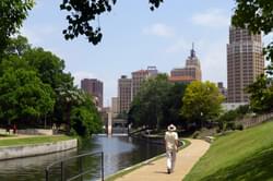
The San Antonio River Walk curves through the grid of city streets in a loop off the main channel. This lively pedestrian system is lined with busy cafes, shops and hotels, set in a lushly planted, closely confined space. it's a redevelopment paradise.
The impetus for developing River Walk was the flood of 1921 which killed 50 people and cost $50 million. Among the proposals to curb the stream inside San Antonio was the ultimate flood-control solution — put it in a large pipe and bury it. City officials favored the practicality of this idea, but a now famous community group sprung up in 1924 to advocate more than flood control.
The San Antonio Conservation Society envisioned a more beautiful and vibrant city, and its members, mostly women, were willing to work for it. Since that confrontation between enlightened civil engineering and unapologetic civic pride, a series of citizen leaders has elevated River Walk to a public amenity drawing nine million visitors a year— the most popular single destination in Texas. At the same time the sophistication of San Antonio engineering has grown and the river is a model of innovative technologies.
The ambiance of River Walk is its main attraction. In the face of powerful anti-traditional trends of modern architecture emerging in 1937, a local architect, Robert Hugman, developed a rich, regional vocabulary using stone channel walls and arched bridges, and applied it at an intimate scale throughout River Walk. Hugman inserted himself and his ideas into the project, producing elaborate drawings and watercolors which influential people endorsed.
San Antonio's River Walk is an inspiration to Trails and Greenways designers urban waterways planning, rai-ltrail corridor study, recreation path system, linear National state park, develop process public input, adjacent landowner, state federal agency partnership, American federal right-of-way abandoned, hiking, bicycle, pedestrian, study, link system connect
Today, River Walk is internationally admired for its appearance and the tremendous economic benefits it produces. The intervening 50 years saw many setbacks for public amenity that was to support so much private investment. In retrospect, it was neglected, businesses would not front on the river and it was unsafe. The Paseo del Rio association sprung up then in response to another set of evocative drawings, these from a committee study by the local AIA chapter, and done by architect Cyrus Wagner.
A $30-million bond issue was passed in the '60s to upgrade the river for Hemisfair, linked to the original River Walk by a new spur in 1968. Regretfully, many historic buildings and urban design opportunities were lost. The Hemisfair structures themselves are gigantic in relation to the river, simplistically planned and introverted in appearance.
Twenty years later another River Walk spur was built to River Center, a multi-million dollar mixed-use development dependent on the river for much of its appeal. The exquisitely detailed project was designed with a clear sense of the benefits of relating to the waterway and the larger public pedestrian system of the city.
Since 1968, the river also has attracted housing development, much of it selling for very high prices. San Antonio Architect Stanley Black wrote in 1979: "As with any downtown revitalization project, it is understood that housing, complete with self-supporting activities to provide self-sufficient lifestyles, is the ultimate goal."
River Walk extends 1.2 miles with a meandering walkway along both banks, often only four feet wide, with no guardrails. Several bridges, stairways, plazas and fountains were designed by Hugman over the years and all of them, varying within a palette of materials, offer a sense of scale and whimsy. Many other designers, including Jim Keeler and the firm of Ford, Carson & Powell, have followed, largely building on the motifs Hugman started.

Robert Searns has a four-decade history of visualizing, planning, and getting trails and greenway projects built. He was Project Director of Denver’s Platte River and Mary Carter Greenways—both national-award-wining projects. He helped plan the Grand Canyon National Park Greenway, played a key role on the Memphis Wolf River Greenway, and authored the Commerce City, CO Walk, Bike, Fit plan. He has written for Planning, Landscape Architecture, LA China, and American Trails Magazines and has served as Editor-in-Chief of Trails and Beyond Magazine. He chaired American Trails and was a founder of The World Trails Network as well as being a delegate to the America’s Great Outdoors White House conclave. His current book is Beyond Greenways: The Next Step For City Trails and Walking Routes, published in 2023 by Island Press. He resides, writes, hikes, and bikes near Denver, Colorado.
Contact: [email protected]
Forming and Running State or Regional Trail Coalitions – Important Points and Practices
posted Nov 27, 2023
Have you ever wondered how to create a trails coalition in your state or region? This article shares some pointers and discusses the results of a nationwide survey of trails coalitions conducted by American Trails in February 2023.
1,322 views • posted 05/07/2018