GEOWEB® panels are used to reconstruct Kittery Point's walking trail and maintenance road.
by Sue Crowe, Database Coordinator
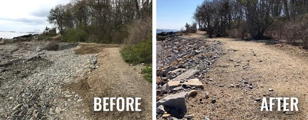
In the spring of 2018, several storms violently swept through areas along southern Maine’s coastline, devastating the beaches and trails of Fort Foster—a town-owned park in Maine. Known as “nor’easters,” these destructive storms form along the east coast, bringing strong winds, rain, and flooding to the New England states. As the storms rolled past, the damage was visible to Fort Foster and Kittery Point’s 2.1-mile-long shoreline walking trail and maintenance road, as well as on the slopes leading down to the beach areas. The shoreline trail is a popular destination for walking, nature trips, bird watching, and sunset views over the water, making its repair a priority for park officials.
The park’s goal was to repair the damage and protect the slopes, maintenance road, and recreational trail from future storm damage. The GEOWEB® Soil Stabilization System (Geocells) was the perfect solution.
Two sections of the park needed their shorelines and trails restored and protected—one was the Large Beach area (702 LF), and the other was the Dive Beach area (577 LF).
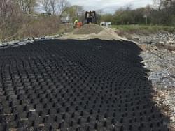
GEOWEB® Load Support for Recreational Trail and Maintenance Road
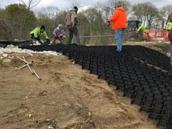
To reconstruct the washed-out recreational trail and maintenance road, 4-inch-depth GEOWEB® panels were installed at the site. GEOWEB® panels are expandable honeycomb-like structures that confine and stabilize soils, creating a long-term, sustainable solution that holds up to severe weather events and can support heavy traffic loads. Individual GEOWEB® panels were connected using the ATRA® Key Connection Device and anchored using 18-inch ATRA GFRP Anchors, prior to being infilled with 1-inch crushed aggregate.
GEOWEB® Shoreline Protection
To stabilize the 2:1 sloped areas down to the beaches, 4-inch-depth GEOWEB® sections were secured to the face of the slope using ATRA GFRP Anchors. ATRA® Anchors provide additional anchorage and resistance to sliding and/or uplift forces to the GEOWEB section with or without tendons for crest, toe, and internal anchoring. The GEOWEB® sections were placed over a geotextile separation layer and then infilled with 1-inch crushed aggregate.
By using the GEOWEB® System, the park was able to armor the maintenance road, recreational trail, and slopes from future storm events. Since its original installation in 2018, the GEOWEB® Load Support & Shoreline Protection System continues to perform as designed, allowing the community to enjoy the trail system and local beaches once again.
Learn more about GEOWEB® Systems at the following links:
Link to YouTube Video
https://youtu.be/MMvCMplZKJY
Free Project Evaluations
https://www.prestogeo.com/free-project-design/
Lunch & Learns
https://www.prestogeo.com/lunch-and-learn/

Sue Crowe joined American Trails in September 2016 as the RTP Database Coordinator after retiring from a career in local government. Sue spent 15 years in fiscal operations and management, with 12 of those years as staff accountant to the Shasta County Regional Transportation Planning Agency. Sue worked extensively on programs in both motorized and non-motorized transportation, including administering grant programs such as Safe Routes to School and the Secure Rural Schools Act.
Sue volunteers at a local animal shelter where she helps to socialize shelter dogs like Honey in the photo. Sue also paints custom pet portraits on rocks and canvas. All proceeds help with special medical need shelter dogs.
Sue moved to Redding in 1987 after growing up in Trinidad, California. She and her husband, John, enjoy hiking with their dog and spending time at their house at Trinity Lake.
Contact: [email protected]
Ice Age National Scenic Trail: Trail Stewardship Notebook
posted Mar 27, 2024
The Ice Age National Scenic Trail (NST) is a thousand-mile footpath highlighting Wisconsin’s renowned Ice Age heritage and scenic beauty. The Ice Age Trail Alliance (IATA) and its partners can shape users’ experiences. As stewards of the land and the Trail, we can help users develop a connection with the land and create a sense of wonder — even pique their curiosity enough to further explore the Trail.
Outdoor Enthusiasts Enjoy the Vermont Shorelines Thanks to the GEOWEB® Soil Confinement System
posted Mar 26, 2024
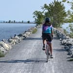
Outdoor enthusiasts enjoy scenic views along the Vermont shorelines thanks to the GEOWEB® Soil Confinement System.
posted Nov 25, 2023
This white paper provides collected best practices on winter bikeway maintenance as seen in US cities and around the world. The paper covers snow removal from bikeways, different types of de-icing surface applications and their advantages/disadvantages, and best practices for winter maintenance prioritization and scheduling. The paper also includes a brief discussion on innovative winter maintenance techniques either in use or in development.
Winter Maintenance Resource Guide
posted Nov 25, 2023
Who is responsible for winter maintenance—property owners or government agencies—and what are the challenges?
550 views • posted 10/03/2022