From Florida Department of Environmental Protection
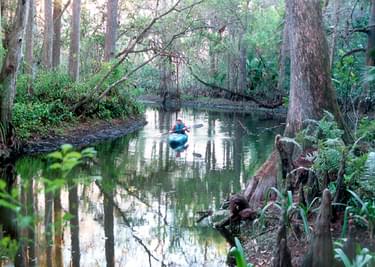
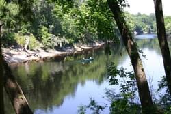
Conceived as an ecotourism destination, the trail enables exploration of the area by canoe or kayak, while providing an economic boost to surrounding rural communities.
For more than 20 years, local citizens, civic leaders and planners have shared a vision that the 206-mile long Suwannee River and the public parks and conservation lands along its banks could provide unique recreational and cultural experiences for Florida's citizens and visitors. Today, approximately 65,000 acres of land along the Suwannee River and about 130 miles (24 percent) of the river shorelines are in public ownership, acquired for purposes of both conservation and public recreation.
After many years of discussion and planning, The Suwannee River Wilderness Trail project (SRWT) is now making the vision a reality. This cooperative project will create a system of facilities, service providers and managers that offers a broad range of recreational and interpretive experiences along the river. But the trail is not limited to the river itself. This system will extend outward to include recreational trails, parks, museums, cultural sites and other nature and heritage attractions in adjacent cities, towns and rural landscapes throughout the Suwannee River basin.
The SRWT is a cooperative effort by the Florida Department of Environmental Protection (DEP), the Suwannee River Water Management District (SRWMD) and the counties, cities, businesses and citizens of the Suwannee River basin. New facilities and management networks for the SRWT are being created to bring a variety of organizations and individuals together, working to protect the unique resources of the river basin and to provide "green" alternatives for economic development in one of Florida's least developed regions. The SRWT will bring real benefits to the citizens of the Suwannee River basin and the state by improving recreational access to public lands, enhancing sustainable economic opportunities in local communities and by greatly improving the coordination and efficiency of the land management activities of state and local governments.
This project is built on foundations of partnership, beginning with a long-standing relationship between the SRWMD and the DEP. The SRWMD and the DEP's Florida Park Service and the Office of Greenways and Trails have worked together as coordinators of the trail project since its inception in 1995. In 2001, Governor Jeb Bush and DEP Secretary David Struhs committed their support to funding the creation of the trail with $5 million over a five-year period. That intention was matched by a promise of equal funding over the same period by the SRWMD Governing Board. The governments of the 8 Florida Counties that border the river, and the governments of White Springs, Lake City, Live Oak, Cross City, Fanning Springs, Chiefland and Suwannee are fully involved in the project, contributing planning and management assistance, advice and political support.
Currently, a network of businesses to provide outfitter services, tours, food, rental equipment, camping supplies, lodging and a variety of other goods and services is being created to support the SRWT, with assistance from Visit Florida - Florida's tourism development agency, local tourism development councils, chambers of commerce and business and civic groups. In the future, it is expected that the greatest proportion of services provided to visitors on the SRWT will come, not from the public agencies, but from local private businesses.
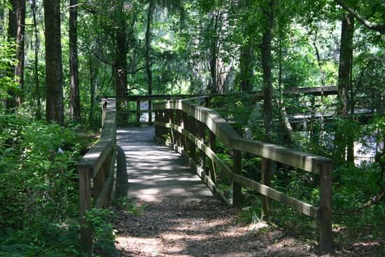
The length of the river from the town of White Springs to the town of Suwannee and the Gulf of Mexico is slightly more than 160 miles. The SRWT will provide single- and multi-day opportunities for a variety of nature and heritage based tours along this stretch of the river, either outfitted and guided by local businesses, or organized by individual visitors. The heart of the SWRT is a concept of recreational Hubs connected to more remote recreational or interpretive sites and points of interest.
The Hubs will provide bases from which visitors may explore the surrounding areas by canoe, boat, bicycle, horseback, or on foot, or enjoy local parks and cultural sites for activities such as swimming, picnicking, fishing, birding and wildlife observation, nature study and interpretive programs. Overnight travelers will have options of lodging at local motels, bed & breakfasts or vacation cabins. Or, they may find accommodations at rustic cabins or campsites that will be built at intervals along the river at state parks, Water Management District lands, local parks or by private entrepreneurs.
Eight hubs have been identified from White Springs in the north to the town of Suwannee at the south end of the river, as illustrated by the attached maps. Each of the hubs will provide day use activities as well as overnight accommodations in rustic cabins, primitive or developed camping areas or at private sector lodgings. Rustic cabins are being constructed at Stephen Foster Folk Culture Center State Park and at Suwannee River State Park, with completion projected for April, 2004. By spring of 2005, new cabin facilities should be in operation at Lafayette Blue Springs and at Fanning Springs State Park.
Seven river camps will support multi-day river, hiking, bicycling and riding tours, allowing visitors to camp near the river at points located between the hubs. River camps will provide covered camping platforms, tent camping areas for self-sufficient campers, screened pavilions for dining and group activities, and a campers restroom. Two river camps scheduled for construction by April 2004 at SRWMD Conservation Areas between White Springs and Ellaville, and two more are now being designed for Conservation Areas between Ellaville and the Town of Branford, for construction by spring or early summer, 2005.
The SRWT initiative has been conceived with an eye toward local communities and existing private businesses as the primary beneficiaries of increasing nature and heritage-based tourism in the region. The trail will be a strong attraction in the growing national and international markets for nature and heritage based tourism. Private entrepreneurs' participation in development and operation of the SRWT will be encouraged. During the past year, a staff position funded jointly by the SRWMD and DEP has been assigned to contact and coordinate businesses in the Suwannee River Basin who may have interest in participating in the SRWT. Partnerships with local chambers of commerce, tourism development agencies and other business groups have been initiated, and the foundations of a business network have been laid.
The successful implementation of the SRWT vision will be the result of synergistic and symbiotic relationships between the public and the private sectors. These relationships will be based on a shared understanding of the values, the opportunities and the constraints of the river ecosystem and the culture of the region.
Resource management and public outdoor recreation are primary purposes of the SRWT project. Public uses of the Suwannee river are already increasing, and evidence of that can be seen the length of the river. At its core, the SRWT is about managing future recreational uses of the river and facilitating it through a well-planned and administered system of recreation areas and programs. One of the goals of the project is that the trail will become a powerful economic incentive for protecting the river's natural resources and environmental values for generations to come.
Great care is being taken in planning for increases in human uses of the river. The site selection process for new facilities is designed to minimize potential impacts. New facilities designs will apply environmentally-sustainable building technology and careful construction oversight to protect development sites.
For the long-term protection and management of the river, DEP has engaged the environmental planning and design firm of Glatting, Jackson, Kercher, Anglin, Lopez and Reinhart, Inc. to conduct a comprehensive baseline data collection and monitoring study. The purposes of the study are two-fold. It will first record current environmental conditions, sensitive resource locations and existing recreational sites in a Geographic Information System data base for a one-quarter mile distance on either side of the river. The study will then create monitoring programs that enable managers to identify and measure changes in the natural and cultural resources of the corridor. This project will empower managers to tailor their responses to any impacts, and to react very quickly to problems, if they occur. The Glatting, Jackson study began in April, 2003. The first phase, documenting baseline conditions and creating monitoring programs from White Springs to Branford, will be completed in the Spring of 2004. Comparable studies will be funded on areas of the river below Branford as the SRWT project moves forward.
American Hiking Society National Trails Day® Event Host Guide (2023)
posted Apr 16, 2024
This guide will provide you with the following resources and knowledge you need to plan and promote a successful event for National Trails Day®.
League of American Bicyclists National Bike Month Guide (2023)
posted Apr 16, 2024
May is National Bike Month, sponsored by the League of American Bicyclists, and celebrated in communities from coast to coast. This step-by-step guide will help you in creating a successful Bike Month event in your community, workplace, city or state.
Making Transportation Planning Applicable in Tribal Communities Research Study: Final Report
posted Dec 20, 2023
The Federal Highway Administration’s (FHWA) Office of Tribal Transportation (OTT) planning staff have observed two challenges in Tribal transportation planning: (1) that existing planning analysis tools do not always align with Tribal community context and needs and (2) it is not always clear what benefits planning provides to transportation project selection and delivery in Tribal communities.
posted Dec 20, 2023
This report and its appendices constitute a review of law, policy, and procedures, with recommendations for changes based on Tribal consultation and public comments.
1,494 views • posted 05/03/2018