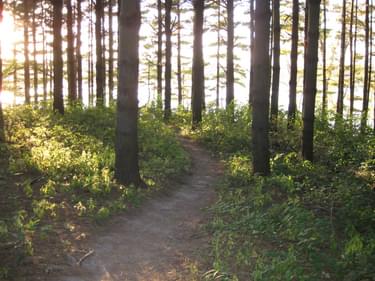
Set in rugged terrain surrounding the Coralville Reservoir on the Iowa River, the trail is managed by the U. S. Army Corps of Engineers.
Designated in 2003
• View more details for this trail
in the NRT Database
• Learn about the NRT Program.
Set in rugged terrain surrounding the U.S. Army Corps of Engineers’ Coralville Reservoir on the Iowa River, 13 miles of trail are arranged as a one-way system of loops to create an extended continuous riding experience and serve riders of all skill levels. For sustainability and reduced maintenance, soil and high water challenges have been addressed with careful design. Sugar Bottom is essentially the birthplace of mountain biking in Iowa, inspiring trails and clubs throughout the State.
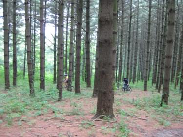
The trails are graded similar to ski trails as easy (green), moderate (blue), and difficult (black). The trail system is arranged as a one-way system of loops. There are three easy main loops, with loops off of each of these which are rated at the higher difficulty levels. The difficult trails enter more rugged terrain and the trails have steeper climbs, descents, and tight turns.
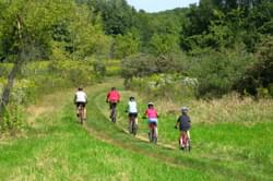
The layout of the trail is one of the best anywhere for flow, and the one way design with complete directional signage enhances safety. The location in east-central Iowa next to the Sugar Bottom campground, Coralville Lake, and near Iowa City and Cedar Rapids make this a great destination for mountain bikers.
In the mid to late 1980’s there was not a public use area or a road to where the beach and trailhead are now located. Local riders were riding a small system of ad hoc trails. In 1990, a one mile section of trail was cut in, in the area of the current 101 trail and a race was held.
The USACE agreed to support a mountain bike trail system at Sugar Bottom, if an organization was created so there could be a formal interface. ICORR was formed and incorporated in 1991. After ICORR had proven itself with the one mile initial 101 loop, trail layouts were approved for the south peninsula. By 1994 the total trail length totaled 5 miles. Expansion of the trail system continued in the mid 1990’s with mileage reaching 10.
Riding the entire system takes close to 1.5 hours at a moderately high pace which has great potential for fitness development.
The goal is to have a beautiful and challenging trail system suitable for both novices and experts which is both sustainable and relatively easy to maintain.
Two features of the Sugar Bottom Recreation Area present design challenges for trails. One is the soil which has very high clay content just below the thin organic layer. This can easily erode once the narrow trail tread becomes compressed and free of vegetation. Trails with the proper slope ratios along and across the trail, and features like grade changes, grade dips and direction changes are still in good condition after nearly 20 years of use. The sugar bottom trails contain no artificial elements to control erosion other than wood bridges to cross natural drainages.
Over the past decade, areas of trails which had proven to be problematic with erosion or chronic wet areas were redesigned to newer improved standards. The design improvements added meandering characteristics to the trails gradually increasing the overall distance to 13 miles, solely through rerouting of existing trails. The smooth interfaces with the loop trails create an extended continuous riding experience.
In the last decade, the trail design focus has been to reduce the amount of regular maintenance the trails require to correct drainage. Trails not well located or with slope and drainage issues have been systematically redesigned over time to reduce the amount of regular drainage maintenance. All trails on softer ground need drainage tuning occasionally, but the goal was to have no maintenance required after significant rainfall, with the trails naturally drying out uniformly.
Signage has been improved over the last few years with complete directional signage for the one-way trail system. During high water on the Coralville reservoir, the gravel access road has sections which are inundated. This requires temporary rerouting of some trails to be 2-way. A series of signs were developed which have covers which can be quickly opened during high water events to redirect trail usage safely during these times. Previously this had been more difficult requiring the deployment of special signs for this purpose. The other main regular effort is maintaining an open trail corridor during the growing season. Some new equipment has been acquired to make this a more efficient process as it can be time consuming.
ICORR conducts two regularly scheduled monthly trail maintenance days which are well advertised through web, email, and phone hotline. These are supported by volunteers who are users of the trail. Typically around 600 hours are recorded for trail maintenance each year.
Take I-380 to exit 4 North Liberty, turn East onto Penn Street. Follow Penn Street to North Front Street, turn North on North Front Street. North Front Street turns into Mehaffey Bridge Road (County Rd F-28). After crossing Mehaffey Bridge, turn south onto the entrance road to Sugar Bottom Day Use Area and Campground.
U. S. Army Corps of Engineers Coralville Lake - www.mvr.usace.army.mil/missions/recreation/coralvillelake.aspx
Iowa Coalition of Off Road Riders - Sugar Bottom Bike Trails - http://www.icorrmtb.org/
Blackstone River Bikeway, Rhode Island
posted Apr 14, 2024
The Blackstone River Bikeway takes you through the heart of the Blackstone Valley. Peddle past historic mills, workers housing, the Blackstone Canal, the Providence and Worcester Railroad, and the Blackstone River itself.
Twenty Mule Team Trail, California
posted Mar 17, 2024
For many people, nothing symbolizes Death Valley more than the famous Twenty Mule Teams.
Hillman Heritage Trail, Kentucky
posted Mar 17, 2024
Located in Hillman Ferry Campground, portions of the trail follow a long-abandoned road that once carried old cars, wagons, and horses to the Tennessee River at Hillman Ferry.
Desert Ecology Trail, Saguaro National Park, Arizona
posted Feb 19, 2024
Located in the Sonoran desert, this paved interpretative, signed trail gives an overview of the plants, animals, and weather encountered in the desert.
2,270 views • posted 03/26/2018