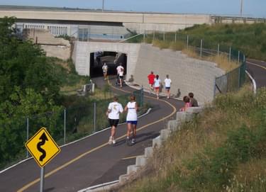
Whether biking, jogging, in-line skating, running or walking is your favorite outdoor activity, the 53 miles of the River's Edge Trail in Great Falls is the perfect venue. The 19 miles of paved urban trail links many local parks and attractions along both sides of the scenic Missouri River.
Designated in 2018
• View more details for this trail
in the NRT Database
• Learn about the NRT Program.
The River’s Edge Trail is Montana’s premier urban trail network and offers the perfect setting for walking, biking, skating or jogging. Along the trail you will find many opportunities for sight-seeing, picnicking, bird watching, fishing, hunting, and retracing the steps of Lewis and Clark. Extensive paved urban trails link with parks, museums, waterfalls, dining options, riverfront attractions and downtown Great Falls. Numerous trailheads provide convenient access to the trail on both sides of the river and connector trails link many neighborhoods. There are a variety of different trails in terms of difficulty and surface types for all levels of recreation as well as 3 non-motorized boat launches along the trail.
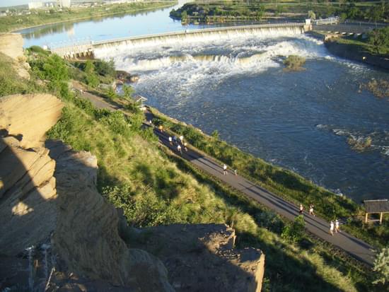
Benches, picnic tables, shelters, rest rooms, and mileage/directional markers all enhance the trail experience. Gaze at the amazing array of art pieces, ranging from large murals to sculptures large and small. You can look down at Great Falls through the free telescopes at the Warden Park Gazebo or gaze up a historic waterfall from Black Eagle Memorial Island where you will cross a historic truss bridge, hear and feel the hum of the turbines and look up at Black Eagle Falls, one of the five falls within the trail system.
Paved urban trails make up about one-third of the 53 miles of the multi-use River’s Edge Trail and include a 3.5 mile loop along the Missouri River in the heart of the city which passes through West Bank, Elks Riverside Parks, and the Dog and Skate Parks. There is also a wonderful 2.1 mile loop through Giant Springs State Park. The loop links together the springs, state fish hatchery, the Lewis & Clark Interpretive Center, the Montana Fish, Wildlife and Parks Regional Headquarters, and Heritage Picnic area.
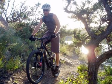
The single track trails located on both sides of the Missouri River east of Great Falls are one of Montana’s top mountain biking destinations and a favorite of hikers, bikers and trail runners. Please do not use these trails when the ground is wet.
The North Shore single track trail, which runs between Rainbow Dam and Morony Dam, hugs the rugged canyon walls, winds through native bluffs and coulees and offers stunning views of the reservoirs, cliffs, and surrounding mountains. Limited hunting is allowed on portions of the North Shore trails.
The South Shore single track trail, runs along the reservoirs from Crooked Falls past the scenic Ryan Dam overlook to the Box Elder Creek canyon, and offers a variety of routes for different skill levels. The most technical trails, known as "Mayhem" and “Chaos”, are located closest to the river.
Local and state Conservation Districts recently funded 7 panels along the trail which provide information on wetlands, shore and water birds, habitat, local floods, early railroads and history of the area, aquatic invaders and the role of Conservation Districts. These join over 30 other interpretive panels along the trail, islands and river overlooks.
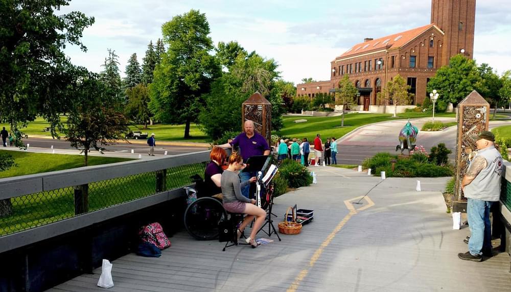
Rivers Edge Trail is the most utilized and most loved public facility in the Great Falls/Black Eagle community. It is the site of numerous public events including the Luminaria Walk, annual races, fun-runs and family fun-rides as well as many of our more than 20 National Trails Day events.
Rivers Edge Trail originated in 1990 as part of a ten year community wide planning process titled, Vision 2000. Fitness advocates saw an opportunity to convert a half mile of abandon urban rail grade to a recreational trail. That first trail segment opened to public use in early 1991. Since then, Rivers Edge Trail has expanded into 53 miles of trail surface ranging from ADA compliant concrete trails to black diamond single-track biking and hiking trails.
While system construction was funded through private donations, grants and volunteers, all trail rights-of-way are owned, managed and maintained by city and state agencies. Multi-agency cooperation is vital to the River’s Edge Trail’s success and its future development. Began in 1990, stakeholders and trail managers meet monthly at a Trails Working Group. This is a public meeting to discuss maintenance, safety, and trail development.
River's Edge Trail is managed and maintained to high standards by the Great Falls Park & Recreation Department and Montana State Parks, with support from the non-profit River’s Edge Trail Foundation. Other partners include Montana Dept. of Transportation, Northwestern Energy, City of Great Falls Planning Dept., Upper Missouri Breaks Audubon Society, Bike-Walk Montana, Boy Scouts, and the Montana Conservation Corps, who helped with construction of a wonderful new single track trail in September of 2017.
Stop in at the Park & Recreation Department on 1700 River Drive N. and pick up your free full color fold-up map of urban and rural River's Edge Trail. Maps are also available at the Great Falls Visitor Center, Bighorn Outdoor Specialists, some trailhead kiosks, and other outdoor equipment stores. You can also view the new interactive trail map at https://greatfallsmt.net/
Got cabin fever? Got friends and family coming? Get your map and go discover your favorite stretch of River's Edge Trail. Maps are also posted year round on 13 of the trailhead information kiosks.
If you would like to know more about the 26-year history of River's Edge Trail, current and upcoming trail projects and how you can help make them happen, visit www.thetrail.org
Blackstone River Bikeway, Rhode Island
posted Apr 14, 2024
The Blackstone River Bikeway takes you through the heart of the Blackstone Valley. Peddle past historic mills, workers housing, the Blackstone Canal, the Providence and Worcester Railroad, and the Blackstone River itself.
Twenty Mule Team Trail, California
posted Mar 17, 2024
For many people, nothing symbolizes Death Valley more than the famous Twenty Mule Teams.
Hillman Heritage Trail, Kentucky
posted Mar 17, 2024
Located in Hillman Ferry Campground, portions of the trail follow a long-abandoned road that once carried old cars, wagons, and horses to the Tennessee River at Hillman Ferry.
Desert Ecology Trail, Saguaro National Park, Arizona
posted Feb 19, 2024
Located in the Sonoran desert, this paved interpretative, signed trail gives an overview of the plants, animals, and weather encountered in the desert.
1,906 views • posted 08/23/2018