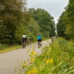
Trails have the opportunity to seamlessly connect vast regions. They become the spine of an active transportation network, that connects people to areas beyond the trail’s reach.
by Richard Allen, Manager of Economic Development, Frontenac County, Ontario, Mike Rose, Principal, Alta Planning + Design, Ezra Lipton, Urban Planner and Designer, Alta Planning + Design
|

Richard Allen is Manager of Economic Development for Frontenac County. For the past 10 years, Frontenac County has embarked on a trails-based economic development strategy centered around the development of the K&P Trail, a 75 KM railway corridor that runs from the City of Kingston to Sharbot Lake. Richard’s approach to economic development brings together 15 years of experience in municipal politics, executive business training, adventure tourism and community development. Richard rides his bike almost daily, but wouldn’t call himself a cyclist. He has also trained for an participated in two half-marathons, but wouldn’t call himself a runner.
Mike Rose is a landscape architect with over 18 years of experience. He is an expert project manager who leads a broad range of planning, design, and engineering projects including parks, soft surface trails, rails-with-trails, and regional trails. He is the Principal-in-Charge for the CVLink Pathway. Mike also leads Alta’s Trails service area, providing strategic oversight to projects across the country. His work ranges from trail connections in rural environments to regionwide greenway plans.

Ezra Lipton is an urban planner and designer with experience working across Canada and in Mexico. He is a creative problem solver with interests in public consultation, GIS analytics, and facility design. Ezra strongly believes in the role that active transportation improvements in the public realm can make in creating beautiful, sustainable places. Ezra previously worked for the City of Toronto on transportation demand management.
posted Apr 17, 2024
This report summarizes guidance and best practices to create safer bicycle facilities and connect them into networks that allow more people to safely bike to more places within and throughout communities.
Making Transportation Planning Applicable in Tribal Communities Research Study: Final Report
posted Dec 20, 2023
The Federal Highway Administration’s (FHWA) Office of Tribal Transportation (OTT) planning staff have observed two challenges in Tribal transportation planning: (1) that existing planning analysis tools do not always align with Tribal community context and needs and (2) it is not always clear what benefits planning provides to transportation project selection and delivery in Tribal communities.
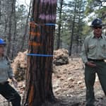
Tribal Development of Trails and Other Dedicated Pedestrian and Bicycle Infrastructure
posted Dec 19, 2023
This white paper provides information and resources for Tribes, Tribal trails and active transportation advocates, and agencies that may partner with Tribes on trail projects including Federal and State agencies, MPOs, county and local governments, and community organizations.
Rails to Trails Conservancy's TrailNation™ Playbook
posted Dec 13, 2023
Rails to Trails Conservancy's TrailNation™ Playbook brings the decades of experience building trail networks across the country to a resource of case studies, best practices and tools for trail network development on a local and national level.
954 views • posted 06/04/2019