From Friends of Milwaukee's rivers
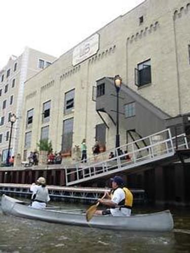
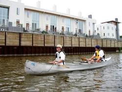
A 35-mile canoe and kayak route through urban reaches of the Milwaukee, Menomonee, and Kinnickinnic Rivers.
Designated in 2006
• View more details for this trail
in the NRT Database
• Learn about the NRT Program.
The Milwaukee Urban Water Trail provides access to the river and boating activities to the 1.5 million people in the Greater Milwaukee Metropolitan Area. The water trail is rich in its complexity encompassing three rivers and a Lake Michigan estuary. Among the many benefits of establishing this trail is the increased awareness users will have about the rivers and its connection to past and present land use, as well as the need to become stewards of our rivers.
Over recent decades, people are once again embracing their rivers. This change in perception is the result of improved water quality, a surge in building and redevelopment along riverfronts, increased interest in recreation, and improved public access. The rivers are now used largely for recreation— from the more natural reaches meandering through parkland enjoyed for their beauty and wildlife, to the more urban portions welcoming boaters to dock along the RiverWalk to enjoy a local beer, dinner, or entertainment.
The Milwaukee Urban Water Trail builds on a series of efforts to bring life back to the rivers of Milwaukee by improving access, water quality, and wildlife habitat. The underlying goal of the Water Trail is to encourage people to enjoy their rivers in a responsible way that protects our natural and cultural resources. Water trail explorers are encouraged to respect these resources and the private landowners and communities that care for them.
A map and brochure was developed to indicate safe and legal river access points and amenities such as restrooms and parking. They also describe the multitude of outstanding natural, cultural, and historical points of interest along the rivers. The map identifies critical areas such as rapids, dams, and natural falls that need to be portaged as well as areas of heavy motor boat traffic.
Art work is incorporated into the trail with the creation of a logo designed by a graduate studio of the Milwaukee Institute of Art and Design. this logo will be used on all directional and access signs and is an essential element of the brochure.
It is common to see kingfishers, herons, egrets, mallards, osprey, and migratory birds, as well as the occasional deer, coyote, mink, raccoon, and frog, among others. Due to improving water quality and river restoration projects such as the removal of the North Avenue Dam, over 30 species of fish can now be found throughout much of the water trail area.
The DNR is reintroducing sturgeon, walleye, and other native fish that once thrived in our rivers, and fishing opportunities now abound, especially below Kletzsch Park Falls and Estabrook Falls and along the Burnham Canal on the Menomonee River. The water trail flows adjacent to the Milwaukee County Parks' Oak Leaf Trail and the newly created Beer Line Trail, which provide quality hiking and biking opportunities that could be combined with a paddle
Funding was received from the Wisconsin Coalstal Management Program, Wisconsin Energy Foundation, Badger State Boating Society, American Canoe Association, Wisconsin Department of Natural Resources, Bert L. and Patricia S Steigleder Charitable Trust, Milwaukee River Revitalization Council, and the Milwaukee RiverWalk District.
The project partnership included Friends of Milwaukee's Rivers, the National Park Service Rivers & Trails Program, Wisconsin Department of Natural Resources, the City of Milwaukee, Milwaukee county, PDI Site Engineering, Badger State Boating society, and many individual boaters.
Friends of Milwaukee's Rivers 1845 N Farwell, Ste 100 Milwaukee WI 53202 (414) 287-0207
Blackstone River Bikeway, Rhode Island
posted Apr 14, 2024
The Blackstone River Bikeway takes you through the heart of the Blackstone Valley. Peddle past historic mills, workers housing, the Blackstone Canal, the Providence and Worcester Railroad, and the Blackstone River itself.
Twenty Mule Team Trail, California
posted Mar 17, 2024
For many people, nothing symbolizes Death Valley more than the famous Twenty Mule Teams.
Hillman Heritage Trail, Kentucky
posted Mar 17, 2024
Located in Hillman Ferry Campground, portions of the trail follow a long-abandoned road that once carried old cars, wagons, and horses to the Tennessee River at Hillman Ferry.
Desert Ecology Trail, Saguaro National Park, Arizona
posted Feb 19, 2024
Located in the Sonoran desert, this paved interpretative, signed trail gives an overview of the plants, animals, and weather encountered in the desert.
1,219 views • posted 03/26/2018