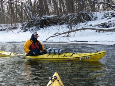
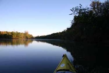
The 400 mile long Des Moines River Water Trail that runs from Estherville to the Mississippi River, is an extremely scenic stream. There are two trail sections - the North Section (Cottonwood to Birdland Park Access) and the South Section (Harriet St. to Yellow Banks).
Designated in 2010
• View more details for this trail
in the NRT Database
• Learn about the NRT Program.
The 20 mile, state designated Des Moines River Water Trail section in Polk County, Iowa provides a unique opportunity to connect a diverse group of trail users, including both rural and urban populations. This 8.8 mile section of the Des Moines River Water Trail is a scenic, historical and natural experience with multiple access points between the Saylorville Dam in Johnston and Birdland Park in Des Moines, IA.
The northern-most access point can be found just below the Saylorville Dam, north of Des Moines in Cottonwood Recreation area, with the southern-most access point being at Yellow Banks County Park, which boasts new paddle-in campsites enabling a multi-day paddling experience with excellent camping amenities.
The trail spawned from partnerships amongst government agencies in addition to numerous clubs and organizations realizing an existing need for a growing population of water users. Beautifully constructed informational kiosks stand at each access point providing information, maps and safety messages pertinent to trail segments.
This unique trail not provides a critical healthy community promotion feature, it also connects with multiple other trails. The intertwining of many trail types can provide a unique opportunity and enable visitors to create their own special experience. Connections to the Neal Smith Multi-Use Trail, which was designated an NRT in the 1990’s, can be accessed at two places along the trail. A mountain biking trail as well as the Trestle-To-Trestle paved biking trail can also be accessed easily from the water trail.
Historically, this meandering river is rich with culture, tradition, recreation and adventure. The first Native American inhabitants, which included the Archaic, Woodland, Oneota, and Great Oasis Cultures inhabitant the area for various expanses between 7,500 BC and 1650 AD. Evidence of this period today reveals numerous burial mounds and encampments remaining along the banks of the river.
Military activity, transportation and industry prevailed along The Des Moines River from the mid 1800’s to the mid 1900’s. The establishment of Fort Des Moines, which was operated for only 3 years was commissioned to protect the Native American Cultures, gave way to the city becoming the state capital in 1857. Steamboats traveled the Des Moines River, providing Iowa’s main commercial transportation across the state and were eventually used as excursion boats for as many as 400 people. An historic riverboat, “Jon Anderson White Riverboat” exists today along the Des Moines River Water Trail. Many historical bridges also dot the landscape and provide a unique view of a rich history from the water.
In addition to the rich cultural tradition this trail signifies, it’s also a wildlife viewing paradise. The northern river corridor of the Des Moines River Water Trail is also appropriately designated as “The Ding Darling Greenway” and exhibits tremendous bird and wildlife viewing opportunities during all seasons. This area has been designated a globally significant birding area by the American Bird Conservancy and is on a major migratory flyway for numerous species.
Specifically, this area provides habitat for more than 6% of the biogeographic population of American White Pelicans, up to 10% of the world's Franklin's Gulls, continentally important populations of Ring‑billed Gull and Caspian Tern, and nationally significant numbers of Bald Eagles. Warblers, many songbirds and raptors also call the area home. You cannot help but appreciate the diverse bird populations throughout this gorgeous river segment. In addition to avian species, you may catch a glimpse of a river otter, white-tailed deer, mink and raccoons.
The water trail provides superb access to anglers of all ages as well. Crappie, walleye, northern pike small mouthed bass, white bass and flathead and channel catfish are just a few of the species in this excellent fishery. Different weather conditions and seasons offer a quality fishing experience at any time of the year.
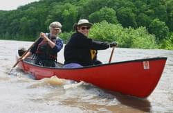
Interest in the Des Moines River Water Trail has also spawned many unique community involvement and stewardship activities. The annual River Run Garbage Grab is held every August, boasting over 350 volunteers spread out along various stretches of the water trail as well as the shoreline cleaning up the river and improving water quality. Following the event, a celebration of the river takes place at Simon Estes Outdoor Amphitheater with live music, food, prizes and fun for all the hardworking volunteers. This event is made possible with partnerships amongst government agencies, clubs and organizations, as well as corporate sponsorships.
Exciting events throughout the seasons also take place on the river trail. Rowing regattas, holiday paddles and other special events highlight the importance of this resource to many people and organizations. Many of these clubs have increased memberships as a result of this trail.
The scenery, history, natural beauty, community involvement and pride in rediscovering this river segment, make the Des Moines River Water Trail a destination and experience you will keep coming back for.
North Section (Cottonwood to Birdland Park Access): Trailhead located south of the Saylorville Dam in the Cottonwood Recreation Area just north of Des Moines. Off Interstate 80, take the Merle Hay Road exit and go north, turn east on NW 70th Avenue, and north on Toni Drive to Cottonwood entrance.
South Section (Harriet St. to Yellow Banks): Trailhead located at Harriet Street River Access. From I-235 in Des Moines head south on Highway 69 (SE 14th Street) for 1.26 miles, turn left onto Harriet Street, follow to the river access.
Blackstone River Bikeway, Rhode Island
posted Apr 14, 2024
The Blackstone River Bikeway takes you through the heart of the Blackstone Valley. Peddle past historic mills, workers housing, the Blackstone Canal, the Providence and Worcester Railroad, and the Blackstone River itself.
Twenty Mule Team Trail, California
posted Mar 17, 2024
For many people, nothing symbolizes Death Valley more than the famous Twenty Mule Teams.
Hillman Heritage Trail, Kentucky
posted Mar 17, 2024
Located in Hillman Ferry Campground, portions of the trail follow a long-abandoned road that once carried old cars, wagons, and horses to the Tennessee River at Hillman Ferry.
Desert Ecology Trail, Saguaro National Park, Arizona
posted Feb 19, 2024
Located in the Sonoran desert, this paved interpretative, signed trail gives an overview of the plants, animals, and weather encountered in the desert.
3,611 views • posted 03/26/2018