This project identifies trail maintenance needs to be addressed by NY-NJ Trail Conference volunteer trail crews.
by New York - New Jersey Trail Conference

The New York-New Jersey Trail Conference (NYNJTC) is a nonprofit organization that works with volunteers and partners in over 150 parks to maintain more than 2,000 miles of trails in the two States. The quality of these trails varies greatly, from old trails to newly-constructed trails, adopted trails to blazed woods roads
While not all trails are meant to provide the same experience, they all require scrutiny of their quality to ensure trail users have the best experience possible. The ability to systematically survey the trails for assets and deficiencies, especially for a nonprofit organization with limited resources working in more than 150 parks, is a major issue that NYNJTC sought to resolve. Nor do many park partners have the funding, manpower, and time necessary to complete a comprehensive survey like this.
With the help of Recreational Trails Program funding, NYNJTC developed a Trail Inventory and Assessment program that uses handheld Trimble GPS field computers, a Geographic Information System (GIS) dataset, a catalog of annotated digital photos, trail condition reports, and accurate maps in print and digital format. The overall purpose of the Trail Inventory and Assessment program is to identify trail features and basic deficiencies on trails.
This information benefits the park partners who, along with NYNJTC’s volunteer leadership, trail crews, and staff, can plan and take action on caring for trail resources in the parks. In addition, this information can help identify where trails can be made more environmentally sustainable, where safety issues need to be addressed, and how certain trails might be changed to improve accessibility to different user groups.
The NYNJTC has been developing its Trail Inventory and Assessment program since 2006. The first step was to obtain the necessary equipment and software, and then modify an existing inventory program used by the National Park Service and Appalachian Trail Conservancy, whose staff members maintain a thorough inventory of the Appalachian National Scenic Trail.
By adjusting the program and using trained volunteers for the on-the-ground data collection work, a pilot project was funded by a Recreational Trails Program grant. Based on results from this pilot project, and with support from the park partners, NYNJTC received additional Recreational Trails Program funding for the “Northwest New Jersey” project.
In the spring of 2014, NYNJTC completed the Northwest New Jersey Trail Inventory and Assessment project. This project inventoried 100 miles of trails in four New Jersey State Parks: High Point State Park, Stokes State Forest, Wawayanda State Park, and Worthington State Forest. The trails inventoried included hiking trails as well as multi-use trails for biking, horseback riding, and other uses.
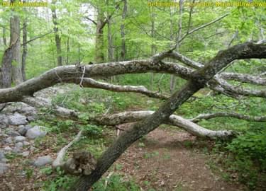
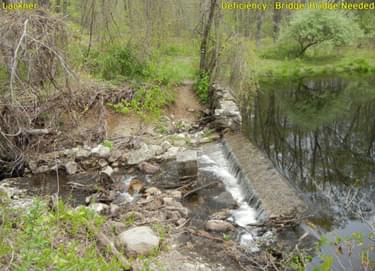
A total of 1,344 trail features and deficiencies were collected, and 12 detailed maps were produced to show locations of collected features, with each feature being symbolized based on feature type and including a unique ID label. A total of 920 photos of features and deficiencies were directly linked to GPS locations, with each photo including annotation about the feature, and detailed trail-by-trail reports were produced to summarize the collected data.
These datasets, maps, photos, and trail summaries are now being used by NYNJTC park partners, volunteers, and staff to identify problem areas, help prioritize trail work, address safety concerns, and even assist efforts to make park-wide trail improvements.
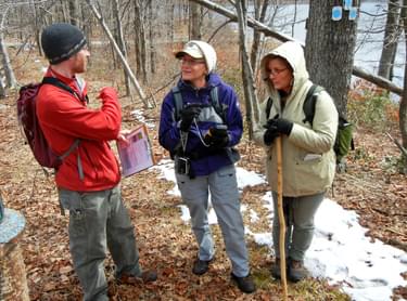
Since NYNJTC had already completed a pilot project, which involved obtaining equipment and software, developing training materials, and creating other procedures, the organization was able to efficiently use these Recreational Trails Program funds. A full-time cartographer and GIS specialist on staff helped manage the project, train volunteers, and perform the technical tasks. Volunteers who receiving training, surveyed trails, and performed maintenance on the trails contributed a volunteer match of more than $11,000, which was nearly 50% of the total $24,000 grant amount received.
The technical requirements for a comprehensive and consistent Trail Inventory and Assessment program are numerous. To collect data in the field, Trimble field computers with GPS capabilities were employed. Terrasync software, a data collection and management tool, was also utilized on the field computers to aid in the collection of trail information using a data dictionary specifically designed for collecting trail data.
The use of the field computers with Terrasync software allowed surveyors to enter descriptive information about trail features and deficiencies in a consistent manner while obtaining accurate GPS location information. A digital camera was also required to take photographs of trail features that could be linked to specific locations during post-processing using GPS-Photo Link software.
Upon completion of data collection, additional processing of the data was performed on a computer using GPS Pathfinder Office and ArcGIS software, including performing differential correction techniques to improve GPS accuracy, eliminating extraneous data or other errors, creating a GIS database of features, and linking photographs to GPSed locations. Detailed maps of the data were then created using ArcGIS and Adobe Illustrator software, and photos were annotated and organized into reports using GPS-Photo Link software.
Trails that have been inventoried benefit the park partners, the NYNJTC organization, the volunteers, and ultimately, trail users who will have better and safer experiences on outstanding trails. The work that has gone into development of the Trail Inventory and Assessment program would not have been possible without the support of the Recreational Trails Program.

The New York-New Jersey Trail Conference maintains over 2,100 miles of trails in the New York metropolitan area.
posted Oct 4, 2023
The 2002 Hayman Fire grossly affected Trail Creek, a tributary to the South Platte River, with a concomitant increase of sediment yield, increases in significant flood events, and reduced habitat quality.
Assessing and Understanding Trail Degradation
posted Jul 15, 2022
This report describes results from a comprehensive assessment of resource conditions on a large (24%) sample of the trail system within Big South Fork National River and Recreational Area (BSF).
TRACS Trail Assessment & Condition Surveys User Guide 2011
posted Jul 22, 2020
TRACS is an organized approach for collecting and updating field data on trail conditions and the work needed to meet standard.
System Wide Trail Assessment: A Spatial Data Driven Approach
posted Jun 9, 2019
In this Trail Talk new methods of mobile electronic data collection help streamline assessments for Tennessee State Parks.
1,181 views • posted 03/03/2018