Tony Boone and Jon Altschuld are both Board Members of the Professional TrailBuilders Association (PTBA), and both will be presenting at the 2023 American Trails/PTBA International Trails Summit. Their companies, Tony Boone Trails, and Chinook Landscape Architecture are Sierra-level sponsors for the conference.
by Tony Boone, COO, Timberline TrailCraft, Jon Altschuld, Founder and Principal, Chinook Landscape Architecture, LLC

The popularity of trails and outdoor recreation has continued to explode since “the Rona” hit in early 2020. This massive increase in hikers, runners, bikers, Off-Highway Vehicles (OHV)s, and strollers has felt like both a blessing and a curse for many land managers, non-profits, and the trail industry on many different levels. An increase in use has brought light to funding and staff shortcomings, which has opened the door to new funding opportunities for many agencies. However, this increase in use has also put more pressure on the natural resources that recreation users love to visit.
This outdoor recreation/trail boom is not unique to public resources. Since the social distancing concept was elevated in 2020, private trail systems have also exploded in popularity for private landowners, ranchers, and farmers. They too are seizing the opportunities of being an outdoor recreation destination and seeing the benefits that recreational trails can add to their quality of life. Sometimes these large private landowners are developing outdoor recreation destinations to use commercially as vacation spots for well-off families and outdoor recreation enthusiasts. Other times, they are creating a private retreat for their friends and families: a place to shelter in, a place to social distance, or a place to get away from their crazy, busy lives.
Regardless of the type of client we are working with, it is cardinal for us to try and balance conservation with recreation. Protecting the natural and cultural resources that have made it so attractive to land managers, landowners, or the general public is crucial to the long-term success of the property. We’ve found that proper master planning for a large property is an important first step to achieving this balance.
Outdoor recreation and trail master planning is essential for large acreage properties to make sure the shared uses will mesh safely and efficiently while minimizing future maintenance costs and any excessive risk exposure. Long-term planning of facilities, trails, and desired outdoor activities is more holistic than looking at the property in smaller pieces, which often results in later finding out you already ruined an opportunity or created difficult (or impossible) to solve conflicts. Looking at the entire parcel through a long-term lens is critical when planning trails, even if the construction needs to take place over several years or decades.
The following are our top 10 requests for outdoor recreation and trails master plans. These are listed generally in chronological order, and many of these requests overlap and are accomplished through a variety of tasks throughout a master planning process.
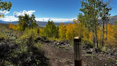
1. Evaluating Existing Trail System and Infrastructure
Although many projects are brand new to the current owner, it is extremely rare to have a pristine property with no existing paths of transit - old roads, two-tracks, or trails (maintained or unmaintained). Possibly our most common request, and typically one of the first tasks of the process, is to GPS the existing trail system and assess trail sections as poor, fair, or good condition. Often, we also evaluate the existing trail use by observing the various user types, the different experiences offered (urban vs. backcountry), and whether the system satisfies users or has after-dark, rogue trail builders developing the system.
Clients basically want to know what’s working and what’s not and how much it will cost or how many volunteer hours it will take to fix. This includes identifying which sections of trail to keep and which ones to obliterate and reclaim. Prioritizing trails and trail sections for routine maintenance programs or trail rerouting is commonly based on the level of use, type of use, level of sustainability, possible hazards, costs, and other environmental/biological constraints.
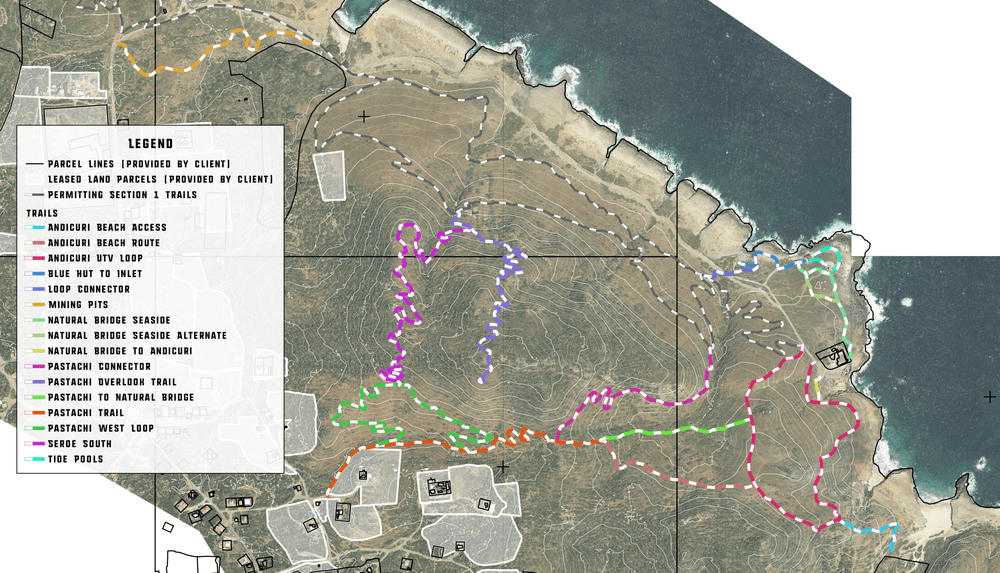
2. Accurate Mapping and Cartography
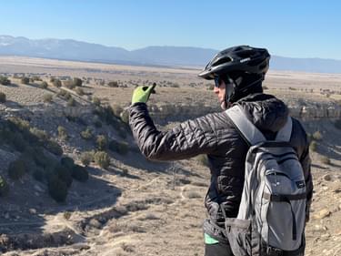
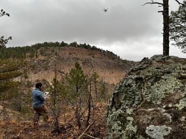
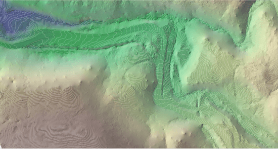
The use of drones, photogrammetry, and LIDAR ushered in a new era of trail planning and design. These tools allow us to efficiently recon and evaluate areas quickly for future trail concepts. They also allow our clients to easily visualize the proposed new trails or reroutes without ever leaving their office. While these tools don’t replace field work, they certainly make field work far more efficient and targeted.
An important first step in understanding a site is acquiring and layering existing datasets, such as wildlife habitat and migration routes, mapping data (manned aircraft LiDAR and photogrammetry), FEMA floodplain maps, NRCS soil information, natural heritage program datasets, and any other relevant basemap data (parcel lines, hydrology, etc.) sourced from counties, municipalities and other public agencies. Combining all these various datasets into GIS allows our teams and the public to better understand the relationships between the natural and man-made opportunities and constraints that exist at each project site.
3. Stakeholder/Working Group/Community Involvement
Our mantra for when to ask for public comment on public trail planning projects is “the sooner the better.” Early engagement of surrounding neighborhoods, local advocacy groups, and conservation organizations leads to more balanced support and better relationships with advocates and opponents alike. Late engagement often leads to adversarial meetings and a lack of trust, limiting the potential success of the project. Early engagement will often even convince some opponents of the project to become advocates for it.
When we collect and analyze public, stakeholder, and working group input in an accurate and efficient way beyond the basic public meetings (especially virtual ones), we use a few handy and unique tools. GIS-based input applications like Survey123, Fulcrum, and ArcGIS Field Maps allow us to collect public input in a geographically accurate setting; in a nutshell, the public can submit info about actual locations from their phones while they are on trails at the location they want to give us info about.
4. Proposed Improvements (Planning)
Once our teams sufficiently glean what folks want and don’t want, determine where critical flora and fauna exist, and fully understand the opportunities and constraints of our project site, we can start digging into the planning phase, where we’ll be identifying new trails and recreation improvements.
This is the point where we typically start developing and conceptualizing a stacked loop system of sustainable trails to try and meet the desires of all ages, all abilities, and all desired user groups. Using existing trails where both feasible and sustainable is a top priority in minimizing the footprint of new construction and helping manage the overall costs of the project.
Getting inside the head of your users is key to understanding and appreciating the different goals of various users and the possible conflicts between them. Often, they have “starter” ideas of what they want, but it takes a seasoned professional to think creatively about what they didn’t realize they wanted. User-optimized trails for hikers and mountain bikers have increased in popularity; challenge staircases for hikers and runners are becoming as popular a request as flow trails are for mountain bikers. The ultimate goal of the planner and manager is to reduce the occurrences of goal interference between different user groups or sometimes even within the same user group.
Many of our private clients are looking for an outdoor recreation plan that includes a trail plan nestled within it; the trails serve as the backbone of these properties, connecting the built and natural amenities. These robust plans offer a significantly wider range of outdoor pursuits than just trail-based recreation. Our most common non-trail recreation requests include archery courses, skeet ranges, corn holes, horseshoes, sledding hills, campsites, picnic areas, angling access, frisbee golf, and interpretive/educational signage for kids and grandkids.
5. Trail Closures and Reclamation
Evaluating the existing trails inevitably ends with closing and revegetating certain trails or trail sections that are not sustainable or, in many cases, even maintainable. Rerouting the unsustainable sections of the trail means the old sections will be abandoned, obliterated, reclaimed, and signed in hopes of users not reopening it.
Closure and reclamation should also address minor and major erosion concerns by restoring proper hydrology in the area. Simply closing a fall line trail to the public with a sign and a few dead trees is rarely adequate to prevent excess water from flowing down the trail and continuing to erode and gully even without any visitor use. The reclamation must also restore a natural environment that is similar to what existed pre-trail.
Adding signage that has an educational approach and explains the reasons for the closures gives reclaimed trails a much higher chance of remaining closed than simple “trail closed” signs, which are commonly ignored or even taken down by users. It’s also a logical practice to not close any trail sections until the reroute or replacement route is open.
6. Trail Stewardship and Maintenance Plan
Many of our planning requests from public entities also desire a trail stewardship plan, and/or a routine maintenance schedule with specific tasks and associated hours/costs. Matching the various tasks properly and in a timely fashion to volunteers, in-house staff, or professional contractors is integral to achieving a balance that keeps volunteers engaged while also ensuring the desired product is within the capabilities of the various labor sources.
One of the quickest ways to lose your volunteer workforce is by giving them a job to accomplish with rudimentary hand tools when it would have been more efficient and safer to involve an agency or private contractor with heavy equipment and specialized experience.
Volunteers are best used as your routine eyes and ears on the project and to conduct basic routine maintenance on sustainable trails. Brushing and drain clearing are two maintenance tasks that are easy to teach to volunteers and provide clearly observable results, something that makes volunteers feel their time was valued. They also excel at monitoring actual, real-time trail conditions, especially after storms. Monitoring signage, fencing, and other trail-related infrastructure can also be rewarding tasks for volunteer organizations.
Private contractors are great options for tasks that require specialized training, or heavy equipment or are simply too large of a job to ask volunteers to take on. Routine inspections to ensure trails are safe and usable can be conducted by staff or private contractors and sometimes by volunteers depending on their qualifications and the types of trails/features. Including inspection schedules in the maintenance plan is a great way to minimize liability and risk exposure while staying ahead of trail upkeep costs and needs.
7. Signage Plan
We often recommend several types of signage for our master-planned trail systems. We typically separate them into 3 categories: 1) wayfinding or directional signage, 2) regulatory signage, and 3) educational/interpretive signage. Not every project needs all three, and deciding which sign categories are needed requires understanding the needs of the client/user groups and the opportunities the project site offers.
New technologies offer us additional ways to share information and minimize the signage, especially in areas prone to vandalism. Using QR codes, interactive/digital maps, and custom apps allow significantly more information to be shared with trail users while minimizing the need for excess or verbose signage that folks often ignore.
8. Pemitting and Engineering Needs
Many projects have a need (and a legal requirement) to acquire certain permits and approvals prior to construction. While going through the full permitting process during a master plan is usually overkill, many master plans benefit from creating an outline detailing what permits, licenses, and engineering requirements the proposed trail improvement may need in order to move forward. This permitting plan provides the client with an estimate of the time and fees associated with each permit so they can plan for implementation. These permits often include the National Environmental Protection Act (NEPA), if federal land or money is involved, grading and storm water management plans (SWMP), floodplain/Clean Water Act permits, proper business licensing, and adhering to all applicable state and local building codes.
In addition to permits, many projects have unique features that will require specialized design. These could include structural engineering for bridges and abutments, geotechnical engineering for rockfall mitigation, or hydrologic modeling for floodplain impacts.
9. Cost Estimating and Phasing Plan
Cost estimating is a key benefit to our private and public clients so they can get an accurate construction (and permitting, etc. if required) budget estimate and begin acquiring capital for the next phase(s) of the project. Oftentimes, clients will choose to phase the construction over a number of years based on budget restraints and grant/funding cycles. Proper phasing plans ensure each phase can operate sustainably and independently of unbuilt future phases.
Proper master planning also allows clients to look at the long-term goals of the project and compare the costs of each trail or trail segment. This empowers them to make more informed decisions about which trails are best to get done first and which ones can wait until later. We always recommend that public land managers build their easy and moderate trails first to reach the largest demographic of users, saving more difficult trails with fewer potential users for later phases.
10. Professional Presentation Materials to Share Master Plan
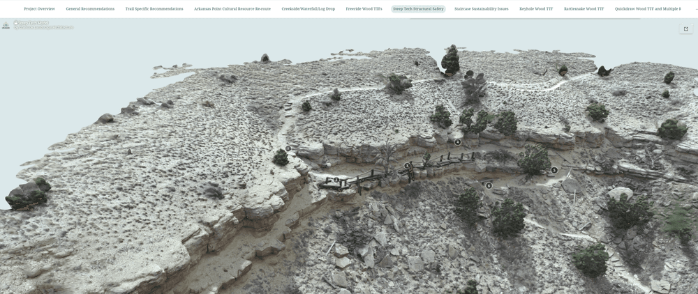
Sharing the work we have accomplished with the public or our private clients is much easier and more effective now compared to a mere decade ago. GIS mapping, 3D modeling, visual exhibits, drone images and mapping, ArcGIS Online – StoryMaps, WebMaps, and WebApps - are all amazing tools that let us guide viewers through our site assessment, planning, and design processes. Not only does this provide more information in an interactive format, but it lets us share this information with the masses without trampling the earth from a dozen folks walking the corridor alignment.
11. BONUS Final Design and Field Layout
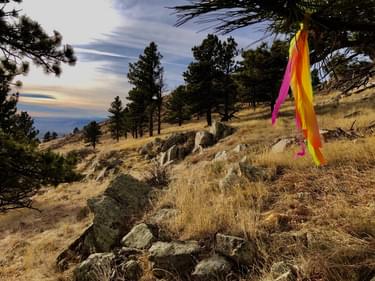
This phase is essential before turning any earth and encourages the master planned trail concept to be laid as gently on the land as possible. It allows the flat trail map to be interpreted into a sustainable, rolling contour design. While the master plan will define a corridor for each trail, this corridor could be 50’ wide, or even wider for certain scenarios. Final design and field layout refines this corridor down to a single flag line, flagged with intervisible vinyl flagging or pin flags on the land. These flag lines show where the trail will be built, and the flagging makes the trail easy to follow and shovel ready. This is the final step before construction begins, and depending on the project, it is often conducted at the completion of the master plan.
When designing new trails for clients, we always rely on our trusty inclinometers, or “clinos” as we refer to them. These small, handheld tools are one of the most valuable tools for trail professionals. They allow us to shoot grades in various terrain, climates, and soil conditions, and ultimately help us measure the various grades that inform the sustainability of the trail and overall difficulty of the trail experience.
Detailed construction notes for trail specifications and features are also documented to assist the builders in meeting the vision of the client. Flagged alignments are always GPS recorded and combined with the construction documents.
Walking the various alignments with qualified trailbuilders that intend to bid on Phase 1 is typically our last step in the master planning process for private landowners. In some cases, we are also hired as owner’s representatives to assist with contract preparation and management and provide quality control of the builders product.
It behooves us to help ensure the chosen contractor(s) can be trusted to implement the client’s vision and not their own. This helps us ensure our master plans are interpreted and built sustainably, while also minimizing risks and ensuring a high quality trail experience for the intended users.
Summing it up in one of our favorite quotes from a mentor, Jim Angel, in the early 1990’s, “People Don’t Need Trails, The Land Does,” we passionately believe that proper trail master planning and sustainable design is our best way to protect our natural and cultural resources for future generations. We believe trails are one of the greatest ways to get our youth, our future stewards, into the great outdoors so they too will appreciate it and want to conserve it.

Tony Boone is a pioneer in the evolution and art of planning and creating sustainable trails for mountain bikers, hikers, runners, and equestrians, having completed over 400 successful trail projects encompassing fifteen U.S. states and nine countries. His accomplishments include the first official mountain bike patrol in Colorado in 1989, training eight International Mountain Bicycling Association (IMBA) Trail Care Crews (1997-2011), inspiring and conducting mechanized trail dozer training for IMBA Trail Solutions (2001), and contributing to three IMBA books: Trail Solutions: IMBA’s Guide to Building Sweet Singletrack, Managing Mountain Bikes: IMBA’s Guide to Providing Great Riding, and Bike Parks: IMBA’s Guide to New School Trails. During his career, Tony has taught over 3,000 students worldwide the art of sustainable trail design, construction, and management.
Currently, Tony is the owner of Tony Boone Trails and the Business Development Specialist for Timberline Trailcraft. Tony holds a Bachelor’s of Science degree in Animal Science, and a Master of Education focused in Outdoor Adventure Recreation.
Contact: [email protected]

Jon Altschuld is Landscape Architect (Colorado and California) with over 12 years of experience. As the founder and principal of Chinook Landscape Architecture, he is experienced in the design of natural areas, trails and open spaces, ecological restoration, parks, streetscapes, and transportation planning, and has an expertise in drone data collection, presentation graphics, 3D visualizations, master planning, and GIS mapping applications. His visualization work has been featured in the ASLA’s sustainable design practices video series and in various news pieces on new construction projects. Jon has taught numerous software workshops and given professional training on SketchUp, Vue, CAD, Lumion, and Adobe Graphics programs within the Planning, Architecture, & Landscape Architecture fields. Jon is currently co-authoring 'Drones in Professional Practice,' an educational and professional book set to be nationally published in late 2020.
Contact: [email protected]
Alaska’s Statewide Comprehensive Outdoor Recreation Plan (SCORP) 2023-2027
posted Oct 16, 2023
Outdoor recreation is vital to the lives and livelihoods of Alaskans. The state’s stunning wild landscapes, vast expanses of public land, productive ecosystems, vital cultural traditions, and four seasons of outdoor adventure position Alaska to be a world leader in outdoor recreation.
Gwinnett Countywide Trails Master Plan
posted Aug 16, 2023
Gwinnett County is currently the second most populous county in Georgia with more than 936,000 residents and also has a minority-majority population. By 2050, estimates project Gwinnett could grow to as many as 1.5 million residents, making it the most populated county in the state.
Sun Corridor Trail Alliance Action Plan
posted Sep 29, 2021
The SCTA Action Plan serves as a checklist of guiding tasks for the new organization as it continues to move the Sun Corridor Trail forward.
San Jose Trail Program Strategic Plan
posted Jul 26, 2021
While the Trail Program has identified and documented 133 miles of potential trails, the Strategic Plan is focused on delivery of the immediate 100-mile goal in the most cost effective and efficient manner.
1,141 views • posted 04/02/2023