posted Jul 23, 2020
by Federal Highway Administration
The Guidebook for Measuring Multimodal Network Connectivity is a guide for transportation planners and analysts on the application of analysis methods and measures to support transportation planning and programming decisions. It describes a five-step analysis process and numerous methods and measures to support a variety of planning decisions. It includes references and illustrations of current practices, including materials from five case studies conducted as part of the research process.

posted Aug 21, 2020
by Bureau of Land Management, International Mountain Bicycling Association (IMBA)
In the context of mountain bike trails, excellence is realized when a trail design merges the desired outcomes and difficulty that a rider seeks with the setting in which the outcomes are realized.
posted Mar 13, 2018
This report presents methodologies and tools to estimate the cost of various bicycle facilities and for evaluating their potential value and benefits.

posted Sep 18, 2023
by Minnesota Department of Natural Resources
These guidelines are designed to assist resource managers in conducting management activities that enhance the quality of natural plant communities, wildlife habitat, regional landscape integrity and visual quality, particularly as related to planning, development, and maintenance of trails, water trails, and water access sites.

posted Jun 7, 2018
The purpose of this resource guide is to provide snowmobiling agencies, associations, and clubs with guidelines that are a resource for grooming, maintenance, and increasing community awareness of snowmobile trails.
posted Jan 16, 2018
The Ontario Trails Strategy describes our vision for trails in Ontario and recognizes the many benefits of trails for health and prosperity and highlights the importance of environmental protection.
posted Jan 19, 2018
The purpose of this document is to provide desirable and minimum trail design standards to municipalities applying for county open space funds to develop trail connections. The municipality’s open space plan must indicate connections to existing or proposed county trails, and county parks and historic sites to be eligible for county trail funding.
posted Aug 16, 2023
by Gwinnett County Department of Community Services
Gwinnett County is currently the second most populous county in Georgia with more than 936,000 residents and also has a minority-majority population. By 2050, estimates project Gwinnett could grow to as many as 1.5 million residents, making it the most populated county in the state.
posted Nov 23, 2020
by Gwinnett County Department of Community Services
Gwinnett County is currently the second most populous county in Georgia with more than 936,000 residents and also has a minority-majority population. By 2050, estimates project Gwinnett could grow to as many as 1.5 million residents, making it the most populated county in the state.

posted Mar 26, 2018
The Greenway is a 3.5 mile pedestrian walkway and nature trail along the Hackensack River.
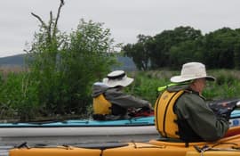
posted Mar 26, 2018
Paddle your way through the mature floodplain forest and rich backwaters of the Winona District of the Upper Mississippi River National Wildlife and Fish Refuge.
posted Aug 18, 2020
The Friends of Hank Aaron State Trail commissioned this Art Concept Plan to lay the groundwork for the placement of public art along the Trail. This Plan identifies sites in which art could most effectively be placed, establishes principles for its placement, and explores how art can go beyond familiar conventions to reinforce the identity of the Trail and its surroundings.
Page 49 of 132


