From the Bureau of Land Management Steese National Conservation Area
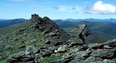
The trail follows ridges above timber line in the vastness of interior Alaska.

Designated in 1971
• View more details for this trail
in the NRT Database
• Learn about the NRT Program.
Pinnell Mountain Trail begins at Eagle Summit, 107 miles east of Fairbanks, Alaska, and follow the ridgelines above timber line and enjoy the vastness of Alaska. Constructed as a hiking/backpacking trail along the southern boundary of the north unit of the Steese National Conservation Area, the trail is managed by the Bureau of Land Management. The BLM hosts American Hiking Society Volunteer Vacations which provide the majority of the maintenance along the trail, from trailhead to trailhead including two shelter cabins.
The Pinnell Mountain Trail was nominated as a component of the National Trails System in 1971. The trail is one of the few maintained primitive hiking trails in interior Alaska. It is managed for a primitive experience, where users feel isolated from the sights and sounds of man, encounter a high degree of risk and challenge, and use outdoor skills.
The trail is considered moderate to difficult with some short sections with gradients of up to 25 percent. Elevations rise to 4,872 feet. Climbing to the top of each ridge can be a challenge but the vast views of the Alaska Range, the White Mountains, the Crazy Mountains and the Yukon River valley are well worth the effort.
Hikers on the Pinnell Mountain National Recreation Trail walk across some of Alaska's oldest rocks. Schist, the predominant rock type, forms the prominent tors jutting from narrow ridge tops on sections of the trail. This schist dates to the Precambrian-Cambrian periods, 700 million to 2 billion years ago, when only the simplest life forms flourished. Other rock types are visible in different areas along the trail. The area surrounding the North Fork Shelter Cabin is composed of granite and on the eastern side of Table Mountain, the trail parallels an intrusion of light gray rhyolite.
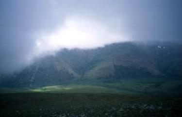
The trail is also an excellent place to view unusual landforms created by Alaska's cold climate. The most visible of these formations are solifluction lobes, which look like draped fabric or ripples on the tundra. Look for them on steep slopes, where freeze-thaw cycles in zones of discontinuous permafrost allow the vegetative mat and top layer of soil to slide downhill over the bedrock. Other permafrost-related features include polygon-patterned ground fissures and "seas of rocks," created over thousands of years as the frost pushed fractured rocks to the surface.
The Pinnell Mountain National Recreation Trail traverses the high ridge line country between the White Mountains and the Crazy Mountains. Storms moving through the Yukon or Tanana valleys reach this high ground and stall. The results are windy conditions, low clouds, ground fog, rain, hail, or snow. Temperatures can drop below freezing in April, while highs can reach to the middle 80's in July. Be prepared for snow at any time of the year.
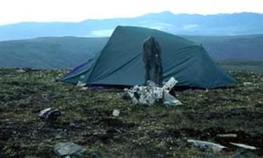
There are two shelter cabins located on the Pinnell Mountain National Recreation Trail. The Ptarmigan Creek Shelter Cabin, is located near mile 10.1 (16.2 km) in a saddle just below Pinnell Mountain. The North Fork Shelter Cabin, is located at mile 17.8 (28.6 km) on the back side of a hill. These small cabins provide emergency shelter, away from strong wind, blowing rain or snow. They operate on a first-come basis. Hikers should always have tents and be prepared to use them in case the cabins are occupied.
Water is available at both shelter cabins from a catchment system constructed to collect melting snow and rain. All water should be treated before cooking or drinking. Other water sources can be found in small ponds scattered along the trail, and in the early summer, snow may be melted. Day hikers should carry enough water for a full day, at least 2 quarts or liters, and backpackers should always carry at least 3 quarts or liters of water.
All of Alaska is bear country. Remember to watch for bears and other wildlife. Cooking should take place outside the shelter cabins so that animals are not attracted to them. Cook food away from sleeping areas and downwind from tents. Always keep a clean camp. Human waste should be buried at least 200 feet (60 m) from water sources, and all garbage, including toilet paper, should be hauled out. Please do not leave food in the cabins for the next people to pack out. Remember, "If you pack it in— pack it out."
Visitors destined for Steese NCA can drive along the Steese Highway and tour preserved gold camps, visit a monument to Felix Pedro, and hunt for caribou and moose. North of Fairbanks, also along the Steese Highway, is Historic Chatanika Gold Camp resort, on the National Register of Historic Places, which continues to be an active gold mining area. At other areas such as Ester Gold Camp, also on the historic register, visitors can tour remnants of mining operations and original buildings.
Whether you are seeking to strengthen outdoor skills, enjoy time with family or friends, escape the pressures of everyday life, or just savor the sights and sounds of nature, the remoteness of this primitive trail provides a chance for solitude, photography and viewing plants in bloom, wildlife or the midnight sun.
To reach the Pinnell Mountain Trail take Steese highway out of Fairbanks, to milepost 107 at the Eagle Summit trailhead.
Blackstone River Bikeway, Rhode Island
posted Apr 14, 2024
The Blackstone River Bikeway takes you through the heart of the Blackstone Valley. Peddle past historic mills, workers housing, the Blackstone Canal, the Providence and Worcester Railroad, and the Blackstone River itself.
Twenty Mule Team Trail, California
posted Mar 17, 2024
For many people, nothing symbolizes Death Valley more than the famous Twenty Mule Teams.
Hillman Heritage Trail, Kentucky
posted Mar 17, 2024
Located in Hillman Ferry Campground, portions of the trail follow a long-abandoned road that once carried old cars, wagons, and horses to the Tennessee River at Hillman Ferry.
Desert Ecology Trail, Saguaro National Park, Arizona
posted Feb 19, 2024
Located in the Sonoran desert, this paved interpretative, signed trail gives an overview of the plants, animals, and weather encountered in the desert.
2,879 views • posted 03/27/2018