By Sena Woodson
Completing the Arizona Trail required careful planning and technical construction of the Ajax Section through a rocky canyon.
It’s five o'clock on a chilly 2011 winter morning. The trail contractor and I hoist our tired bodies into his work truck and drive eighty-seven miles Northwest from his home in Cave Creek, Arizona. We cruise through the morphing pastel orange and yellow sunrise for nearly two hours, finally reaching the small, historic town of Superior. Gravel crunches under the tires as we pull into a local cafe parking lot. We hop down from his dusty Dodge truck as other trail workers and project planners arrive in their vehicles. We greet one another and head into the aged breakfast cafe, ordering eggs, sausage, toast, hash browns, and drink steaming black coffee in preparation of the long workday ahead.
The trail that Matthew Woodson, owner of Okanogan Trail Construction (OTC), and his skillful crew are developing is called the Arizona National Scenic Trail; it has been under construction for nearly 25 years. The trail stretches over eight hundred miles through Arizona's diverse terrain, from the border of Mexico all the way to Utah.
OTC is only working on a nine-mile portion of the lengthy trail, but it is the last section to be built and will connect the two completed sections together. This particular area of the Arizona Trail is very craggy, which makes it extremely difficult to develop. OTC, project planners, and specialty contractors must work closely together on the remote job.
At the breakfast table, Woodson discusses workday plans and strategies with his trail crew and Bureau of Land Management (BLM) planners. The access point for most local Arizona Trail users is the Picketpost Trailhead, 6.8 miles from Superior. For the trail business, however, the trailhead route is not time efficient, nor does it lead directly to the construction site. Instead, we get back into the vehicles and drive a few miles out of town on a dirt road, arriving at a gravel clearing at the base of several jagged mountains. One OTC worker hops onto a muddy yellow dirt bike, while the remaining nine of us pack into two vehicles, a four-wheel drive Toyota rock crawler and a Jeep Rubicon.
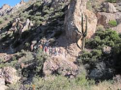
Peering up at the rough mountains, abundant with cacti and Creosote Bushes, it seems a ridiculous task to attempt to drive upward. Nevertheless, to my surprise, the vehicles proceed through boulder barricaded washes and up the rugged terrain without much struggle. To me, this already seems like an extensive trip just to arrive at work, but it is something the crew does every day. We bump and bounce around traveling up the seemingly non-existent Forest Service Road for an hour and twenty minutes, eventually coming to a stop on a flat sandy peak. We unload from the trucks and gaze out at the magnificent view of Martinez Canyon, full of towering rock formations, Saguaro Cacti, and soaring hawks.
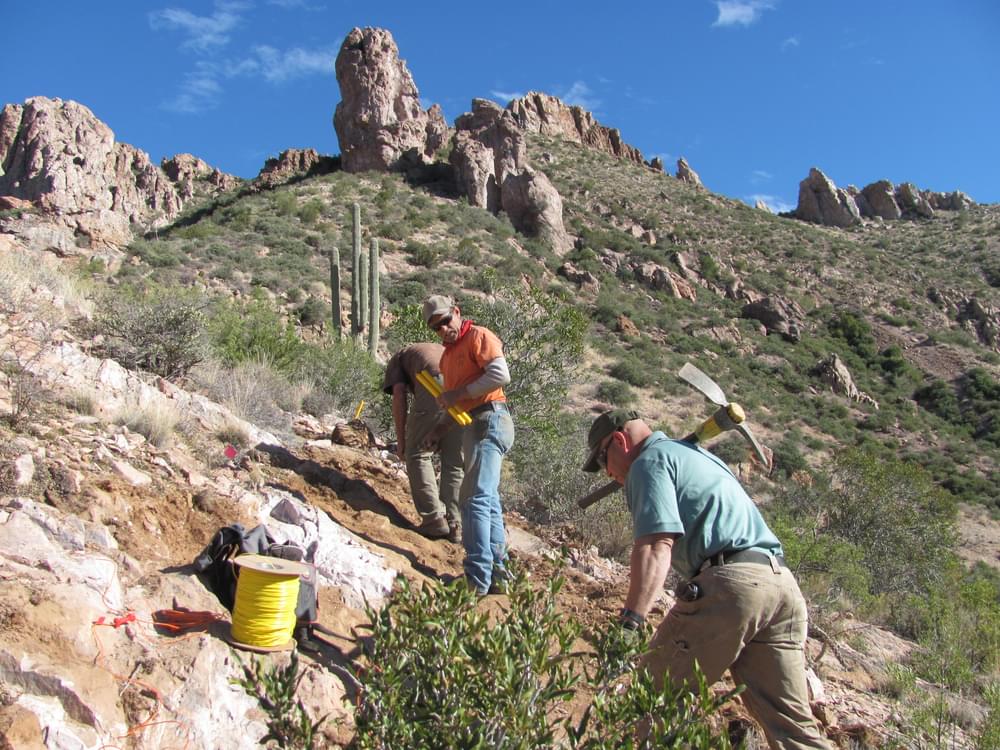
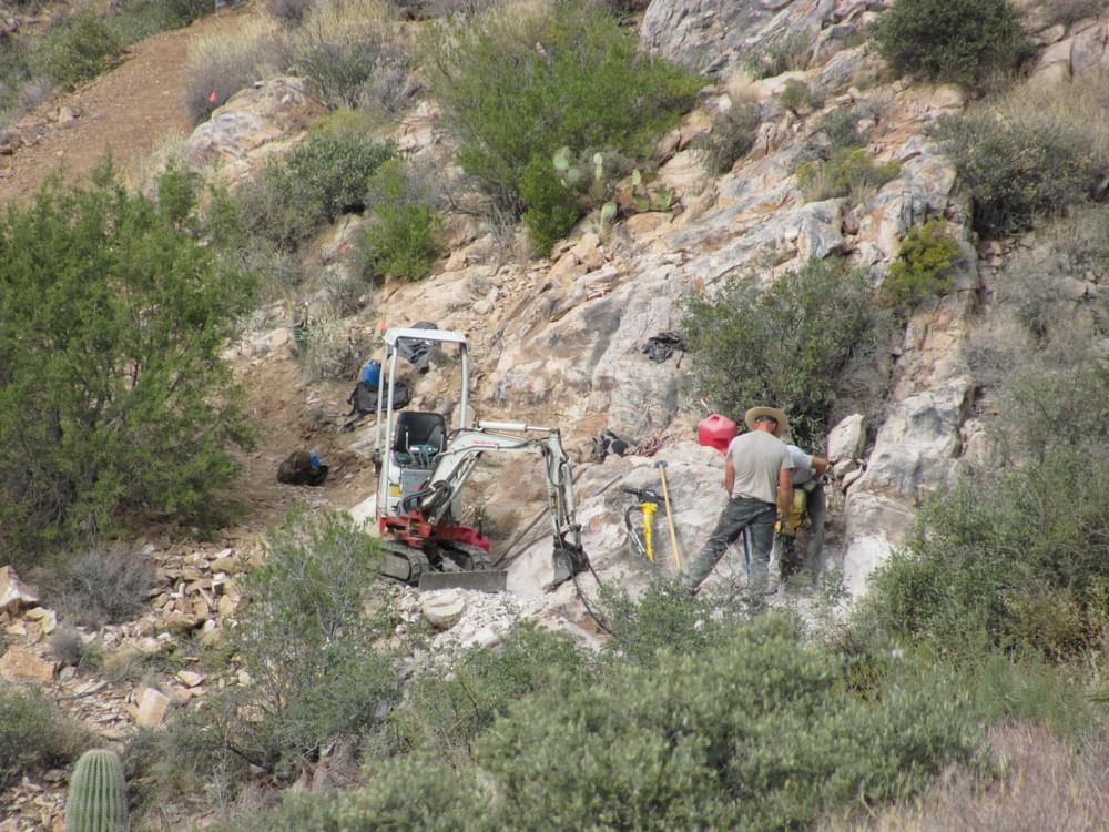
The sun now directly overhead, it is much hotter than when we left Woodson’s home that morning. Each worker gathers gear from the trucks and hikes down the freshly built trail, stopping where it abruptly ends. They quickly pick up their tools and begin to jackhammer, dig, and cut away at the mountainside, leaving a cleanly manicured trail behind them. A massive ridge, however, protrudes into the next section of the paths proposed course. The rock, impossible to break though with small tools, must be tactically blasted with dynamite to create a precisely angled crevice for the trail to fit into. Woodson has hired Cort Potter, a professional blaster, for this exact purpose.
Potter and Woodson collaborate with Mariano Lanza, Bureau of Land Management’s Surface Protection Specialist, who was assigned on the project as a Technical Advisor for the application of energetics. Together they carefully analyze the site geology, deciding if it is appropriate for blasting. Next, they “design the blast and zero the proper blasting materials that match the geology and are best for the environment,” says Lanza. Once the planning is established, they place the dynamite into carefully drilled holes in the rock. Potter connects a long wire to each individual piece of dynamite and rolls it yards away from the area. He then instructs everyone to hide even farther than him from the rock as he prepares the detonation.
"Fire in the hole!” Potter yells. The air goes momentarily silent before the blast echoes off the canyon walls and thousands of rock shards fly like buckshot through the air. "If you get hit with one of the shards, it could go through you like a bullet," says Potter. I then truly realize the importance of planning and hiding far from the blast. Potter performs a couple more successful blasts and an outline vision of the intended trail is revealed. OTC workers again chip away at the remainders of earth, creating a beautifully constructed three-foot wide trail in the rocks edge.
Back in the 1970s, a man named Dale Shewalter had dreamed of the possibility of having a trail that connected all of the diverse areas of Arizona. However, it wasn’t until the late 1980s that the Arizona Trail construction began. Due to the trail’s length, sporadic sections of the trail were built over time; the last section of the trail still remained to be built by the end of the 90s. In the winter of 2000, Francisco Mendoza, BLM’s Outdoor Recreation Planner, and the Arizona Trail Association (ATA) began planning and pushing for the project’s completion. “My interest in the Arizona Trail was that it be properly planned and designed to accommodate the target users (hiking, equestrian, mountain biking), that it avoid sensitive areas, [and] that an adequate environmental review was completed,” said Mendoza. Under law, the order of planning and development was extensive.
After consideration of public interest, working with the ATA, Forest Service and Arizona State Parks, and obtaining funding, grants, and permits, new development was finally underway in 2003. A three mile section of the trail “was done with hand tools and labor by a Southwest Conservation Corps (SCC) youth crew funded by a grant from the National Park Service Rivers and Trails Program,” said Mendoza. However, the next section was too rugged for the volunteer crew to undergo and required professional trail construction. On May 27th, 2010, OTC was contracted to finish the job.
“Francisco Mendoza did the basic outline of the corridor and drew a general route for the trail to go,” said Woodson. According to Mendoza, it took BLM, ATA, volunteers, and National Forest agencies from 2003 to 2005 to plan the preferred route. In November of 2010, OTC began construction on the last link. The canyon’s geology resulted in the careful implementation of the trails design.
“The Ajax Section Okanogan [Trail Construction] worked on is the most wild section of our passage,” said Mendoza. The steep canyon walls and rampant vegetation only made it practical for Woodson to lay out a maximum of one mile of trail at a time. The trails completion required a lot of time and resources, and according to Woodson, “it took one month to build one thousand feet of the most difficult section of trail.”
With more than thirty years of experience in trail building and a crew of veteran trail builders, he was able to use the corridor that Mendoza provided him to decide specifically where the trail should be laid. “Basically I have a very hands on approach and highly skilled workers,” Woodson said. He is able to give design instruction to his crew and they implement his ideas into a workable solution.
On December 16, 2011, a little over a year after OTC’s construction began, it was finally time to celebrate the trails completion. A ceremony was held on the Arizona Trail, two miles East of Kelvin, which is the next town south of Superior. “Arizona Trail notables, those deeply involved with the dream and construction of the trail, were on site with trail tools to complete the last symbolic footage to tie together the two completed trail portions,” said Woodson. The dream and construction of the trail that began so many years ago was finally finished. According to Mendoza, the completion of the trail was symbolically “like having a baby.” After tons of hard work preparing, designing and constructing the trail, there was much satisfaction in knowing it was completed.
However, like having a baby, Mendoza realized that the trail was an ongoing project and that they would “now have to take care [of] and feed it.” He says that he and BLM are now considering possible plans for proposed mine dump projects that would affect the area, trail protection strategies, and that they will likely have to maintain similar efforts well into the future.
The Arizona Trail’s completion is a mark of success for many people, including Dale Shewalter, who originally envisioned the trail, as well as BLM, ATA, and OTC, who aided in completing Shewalter’s vision. Although he died before the trails completion, Shewalter’s legacy continues with the trail and it’s users. Every year adventurers journey various lengths of the eight hundred mile trail by foot, horse, mule, and bike. It is not only used recreationally, but also in many different types of events, such as extensive bike races, running races, as well as an 800-mile hike to raise money to help fight Polio. Through large wilderness regions, like the Mazatal Wilderness, and historical sites, like the Grand Canyon, the trail’s path highlights many types of wildlife, vegetation, and geographical wonders. These qualities make the Arizona Trail an alluring destination for wilderness enthusiasts and anyone who wishes to experience the beauty and diversity of this state.
Ice Age National Scenic Trail: Trail Stewardship Notebook
posted Mar 27, 2024
The Ice Age National Scenic Trail (NST) is a thousand-mile footpath highlighting Wisconsin’s renowned Ice Age heritage and scenic beauty. The Ice Age Trail Alliance (IATA) and its partners can shape users’ experiences. As stewards of the land and the Trail, we can help users develop a connection with the land and create a sense of wonder — even pique their curiosity enough to further explore the Trail.
Outdoor Enthusiasts Enjoy the Vermont Shorelines Thanks to the GEOWEB® Soil Confinement System
posted Mar 26, 2024
Outdoor enthusiasts enjoy scenic views along the Vermont shorelines thanks to the GEOWEB® Soil Confinement System.
posted Nov 25, 2023
This white paper provides collected best practices on winter bikeway maintenance as seen in US cities and around the world. The paper covers snow removal from bikeways, different types of de-icing surface applications and their advantages/disadvantages, and best practices for winter maintenance prioritization and scheduling. The paper also includes a brief discussion on innovative winter maintenance techniques either in use or in development.
Winter Maintenance Resource Guide
posted Nov 25, 2023
Who is responsible for winter maintenance—property owners or government agencies—and what are the challenges?
769 views • posted 05/23/2018