Spectacular coastal trail on the Lost Coast of northern California's Mendocino County.
Designated in 1971
• View more details for this trail
in the NRT Database
• Learn about the NRT Program.
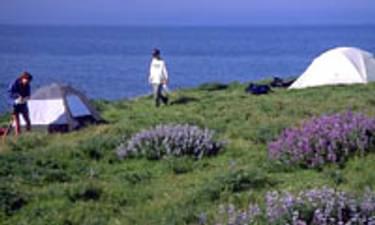
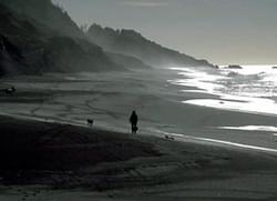
The Lost Coast National Recreation Trail runs 24.8 miles, mostly level beachwalking, in the King Range National Conservation Area. The trail is managed by the Bureau of Land Management from the Arcata Field Office. The Lost Coast Trail is one of the first trails designated as a National Recreation Trail.
A spectacular meeting of land and sea is certainly the dominant feature of the King Range National Conservation Area. Mountains seem to thrust straight out of the surf; a precipitous rise unsurpassed on the continental U.S. coastline. King Peak, the highest point at 4,087 feet, is only three miles from the ocean.
The Lost Coast Trail is a serious backpacking trek, which can be done in three days. Much of the route runs along the beach but there are some challenging sections. Large and often slippery boulders must be negotiated in some area. At several places along the trail rivers cut canyons out of the steep hills running along the coast and run into the Pacific. Campsites along the trail are on sandy river shoals at these river crossings, just above sea level and some yards back from the shoreline. These are also the places where hikers have easy access to the only fresh water along the trail.
A new self-service permit system is now in place for the King Range National Conservation Area, affecting hikers and backpackers who plan to spend at least one night in the back country, including the popular Lost Coast Trail.
The free permits, which also serve as California campfire permits for the King Range, are available in self-service boxes at King Range trailheads, at the King Range Office in Whitethorn and at the Bureau of Land Management Arcata Field office in Arcata. Hikers will be asked to complete a brief form, leaving one part in the permit collection box or at the office, and keeping the second part with them while in the King Range.
Many hikers of the Lost Coast Trail choose to park their vehicle at one trailhead and be shuttled via local transport providers either to or from the opposite trailhead. In order to legally provide transport for hire on public lands, shuttle service providers must be issued a special recreation use permit from BLM. This permit ensures that the provider is knowledgeable of BLM's regulations and requirements for hiking and camping in the King Range and has the proper insurance for transporting people.
For more information:
For additional information contact the BLM, King Range Office at (707) 986-5400 or www.blm.gov/ca/arcata/kingrange/
For current road and trail conditions call the King Range Office (707-986-5400) or the Arcata Office (707-825-2300).
Blackstone River Bikeway, Rhode Island
posted Apr 14, 2024
The Blackstone River Bikeway takes you through the heart of the Blackstone Valley. Peddle past historic mills, workers housing, the Blackstone Canal, the Providence and Worcester Railroad, and the Blackstone River itself.
Twenty Mule Team Trail, California
posted Mar 17, 2024
For many people, nothing symbolizes Death Valley more than the famous Twenty Mule Teams.
Hillman Heritage Trail, Kentucky
posted Mar 17, 2024
Located in Hillman Ferry Campground, portions of the trail follow a long-abandoned road that once carried old cars, wagons, and horses to the Tennessee River at Hillman Ferry.
Desert Ecology Trail, Saguaro National Park, Arizona
posted Feb 19, 2024
Located in the Sonoran desert, this paved interpretative, signed trail gives an overview of the plants, animals, and weather encountered in the desert.
1,530 views • posted 03/27/2018