By Kate Hanson and Ursula Lemanski - National Park Service
Floodplain open space makes economic sense.
The price tag for disaster assistance to Midwesterners after the Great Flood of 1993 was astronomical:
The severity of the 1993 floods led taxpayers, lawmakers and the many federal, state and local agencies that provide flood protection and disaster relief to ask a similar question: How can we afford to repeatedly pay to rebuild in places that flood over and over again?
In response, the federal government made a major shift in public policy. For the first time, a significant share of disaster funding was made available to local governments to "buy out" damaged structures and remove them from floodplains. Now, dose to two years after the devastating floods, a number of Midwest communities are looking forward to the conversion of these areas to public open space.
Few people who pursue the option to be bought out and move from the floodplain are motivated by desire for appropriate land use. They just want to put their lives together after a flood and avoid having to go through the ordeal again. However, a year or more into a project, when negotiations with individual property owners are nearing completion, attention shifts toward the future of the properties. Adjacent landowners have concerns about cleanup and use of the area, and the community as a whole doesn't want it to become an eyesore. People begin to consider the possible benefits of open space.
This has been the case in Iowa, where, as of early March 1995, more than $19 million had been obligated by the State Emergency Management Division to purchase flood damaged homes. National Park Service (NPS) staff are working with three towns that have requested NPS help to develop and start implementing local open space plans for flood buyouts.
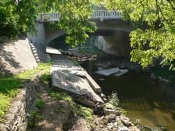
One of the three towns, Cherokee, has Iowa's largest residential Betty: 187 properties in a 67-acre area along the Little Sioux River. The Little Sioux went out of its banks five times in Cherokee between April and July 1993. It had also flooded in 1963, 1965, 1969, 1983, 1984, 1987 and 1990.
Cherokee has been working for a number of years to protect and restore floodplain open space. The city has put in place and enforced strong floodplain ordinances. It also has identified the floodplain corridor as a greenbelt and encouraged private donation of land within the corridor. When the disaster declaration was made in 1993 and hazard mitigation funding became available, Cherokee was quick to act on the opportunity to further floodplain management goals through property buyouts.
For Cherokee, as for other Midwest towns, putting together a project has proved to be an arduous undertaking; one requiring extensive public education, communication with individual property owners, and coordination among an array of federal and state agencies.
NPS is helping Cherokee make its way through the open space planning aspect of their project. Staff have worked with city officials to form a local Greenspaces Advisory Committee, which is sponsoring a workshop to get people's ideas on how to use the area as open space. NPS will help the Advisory Committee and the city review the ideas, compile an open space plan representative of what the community wants, and identify potential funding sources to implement the plan.
Nevada and Audubon, Iowa, other towns that NPS is assisting, have similar open space planning efforts underway for areas.
Like Cherokee, Nevada has strong floodplain ordinances. There is little development along Indian Creek, which runs through town. In a strategic planning effort several years ago, Nevada identified community objectives which included development of a multipurpose trail system. When 13 property owners along one portion of Indian Creek showed interest in a buyout, the Parks Board recognized the opportunity to put a key trail segment in place.
NPS is helping Nevada develop a comprehensive open space plan for the Indian Creek corridor, including the area. Along with trail development, residents are interested in wetland and prairie restoration and environmental education. The Parks Board is exploring opportunities to extend the open space corridor through easements with private landowners and, possibly, purchase of additional property. There is potential for a 60 to 70 acre trail/greenway system within the city limits, most of it in the floodplain.
Audubon residents are working on a plan for an 11-acre area along Bluegrass Creek that will include wetland or prairie restoration for an outdoor classroom, as well as trails, a picnic area, and an athletic practice field.
They are also enthusiastic about the potential to link their area with a nearby rail line that is being abandoned. The line, which extends 30 miles south to Adantic, Iowa, is being considered for a segment of the transcontinental American Discovery Trail. Open space planning for the area has led residents to start working with the county conservation department, trail proponents in Adantic, and statewide trail groups.
By focusing local attention on positive long-term uses of these areas as open space, Cherokee, Nevada, Audubon and other Midwest communities stand to realize benefits much more far-reaching than flood damage reduction. They will be providing opportunities for recreation and conservation education, restoring habitat, reducing soil erosion, and improving water quality. Studies indicate they can also expect economic benefits beyond reduced costs of future floods. For example:
Increased property values: A study of property values near greenbelts in Boulder, Colorado, noted that housing prices declined an average of $4.20 for each foot of distance from a greenbelt up to 3,200 feet. In one neighbor hood, this figure was $10.20 for each foot. (Correll, Lillydahl, and Singell, 1978). The same study revealed that the aggregate property value for one neighborhood was approximately $5.4 million greater than if there had been no greenbelt.
Produced cost of municipal services: A South Portland, Maine, study of development costs indicated that residential development cost $1.30 in directly attributable services for every $1 of revenue from property taxes (Ryan, 1990).
Expenditures for recreation: More than one-fourth of the total national wildlife-related recreation expenditures, $55.7 billion in 1985, was related to bird watching and wildlife photography (U.S. Fish and Wildlife Service, 1988).
Local leaders know that open space can be a tremendous asset to their community, one that can enhance their city's livability, attract residents and businesses, and foster community pride.
--Kate Hanson and Ursula Lemanski are NPS staff assisting Iowa communities with open space planning for buyout projects.
Bridging the Urban-Rural Economic Divide
posted Oct 26, 2023
It’s time for the narrative to shift from urban vs. rural to a shared economic future. Bridging the economic divide between urban and rural areas will require states, regions and localities to understand and bolster the relationship between urban and rural areas in economically meaningful and strategic ways.
Great Allegheny Passage Economic Impact Report
posted Oct 19, 2023
This report was developed by Fourth Economy in partnership with the Great Allegheny Passage Conservancy (formerly the Allegheny Trail Alliance). Research was conducted between the fall of 2020 and the spring of 2021.
2022 CDT Small Business Survey
posted Feb 14, 2023
From August to December 2021, the Continental Divide Trail Coalition surveyed 136 small business owners in 38 communities located along the Continental Divide Trail to learn more about how the Continental Divide Trail impacts their businesses, the local economy, and their support for public lands.
posted Apr 11, 2022
Everything you need to know about the positive impact of trails on health, environment, economics, and more.
1,023 views • posted 05/03/2018