A great how-to for developing educational programs and plans for managing, maintaining, and improving informal trails
by Jeffrey Marion, Ph.D., Federal Scientist, U.S. Geological Survey
The development, deterioration and proliferation of visitor-created informal trails in protected areas can be a vexing management issue for land managers. Formal trail systems never provide access to all locations required by visitors seeking to engage in a variety of appropriate recreational activities. Traveling off-trail is necessary to engage in activities such as nature study, fishing, or camping.
Unfortunately management experience reveals that informal trail systems are frequently poorly designed, including “shortest distance” routing with steep grades and alignments parallel to the slope. Such routes are rarely sustainable under heavy traffic and subsequent resource degradation is often severe. Creation of multiple routes to common destinations is another frequent problem, resulting in “avoidable” impacts such as unnecessary vegetation/soil loss and fragmentation of flora/fauna habitats.
This guidance is provided to assist land managers in evaluating the acceptability of informal trail impacts and in selecting the most appropriate and effective management responses.
Problem Definition: The first step should be an inventory of the informal trail network within an area of management concern. If GPS devices and expertise is available a simple inventory technique is to conduct a walking GPS survey, provided the terrain and forest canopy permit GPS use. GIS software can input, map and analyze the data, providing a visual display of the informal trail network relative to designated trails, roads and other resource features. Computation of the lineal extent of the informal trail network is also possible. If GPS devices cannot be used then an inventory can be made by hand-sketching informal trails onto large-scale maps with lengths assessed by pacing or a measuring wheel.
Where possible, managers may also wish to consider various options for assessing the condition of the informal trails. Many options, ranging from simple condition class evaluations, to trail width and depth measurements, or detailed assessments of soil and vegetation loss are possible. Guidance for assessing trail conditions may be found in the scientific literature (rapid assessment “condition class” options are included at the end of this document) (Cole 1983, Leung & Marion 2000, Marion & Leung 2001). An objective assessment of informal trail conditions can produce quantitative data for indicator variables that can be summarized to characterize current trail conditions, or when replicated, to monitor changes in trail conditions over time. Such data can also be used in formal management decision frameworks such as the Limits of Acceptable Change (LAC) or Visitor Experience and Resource Protection (VERP) (NPS 1997, Stankey et al. 1985). These frameworks are used to guide decisions about the acceptability and management of visitor use and impacts.
Evaluate Impact Acceptability: The acceptability of informal trail impacts can be evaluated informally or formally through a framework like VERP. Managers should first consider the zone and management direction for the area(s) where the informal trails are located. Informal trails located in pristine areas where preservation values are paramount are less acceptable than when located in areas that are intensively developed and managed for recreation use. Trails in areas with sensitive cultural and archaeological resources are particularly unacceptable if they threaten such irreplaceable resources.
Environmental factors should be considered. Informal trails located in sensitive or fragile plant/soil types, near rare plants and animals or in critical wildlife habitats are less acceptable than when located in areas that are resistant to trampling damage and lack rare species. Informal trails that directly ascend steep slopes and/or will easily erode are less acceptable than trails with a side-hill design. Informal trails prone to muddiness and widening are less acceptable, as are trails that may contribute soils to water resources.
Use-related factors should also be considered. Informal trails resulting from illegal or inappropriate types of uses are less acceptable than if they are caused by permitted uses. Is visitor behavior a factor? Impacts that can be easily avoided are less acceptable – such as when three informal trails in close proximity to each other access a location that could be accessed by a single trail. Why is a trail in a particular location and what are the visitors trying to access? Impacts caused by visitors seeking to shortcut a longer, more resistant route are unacceptable, as are impacts caused by visitors who could alternately access their intended destination by staying on resistant durable surfaces (e.g., rocks, gravel, and sand) (www.LNT.org).
A careful consideration of these and other relevant factors (e.g., visitor safety) can assist managers in making value-laden decisions regarding the acceptability of informal trail impacts. The acceptability of these impacts, in turn, guides decisions about which trails should be left open, rerouted, or closed and selection of appropriate and effective management interventions.
Selection of Management Actions: No actions are needed for informal trails found to be acceptable to managers. It should be recognized that recreation access and use is an important mandate for parks. Some degree of degradation to natural resources is an inevitable consequence of recreation use, requiring managers to balance recreation provision and resource protection mandates. Roads and formal trails can never provide complete access to the locations visitors wish to see, hence, some degree of informal trail development is inevitable and must be tolerated.
Informal trails created by illegal users, trails with poor designs, or trails that threaten sensitive resources should generally be closed and rehabilitated. If visitor access to the area in question is acceptable, then a qualified trail management professional should identify an alternate route, with review by resource management/protection staff. An existing trail or previously disturbed route is always preferable, though visitors rarely choose the most durable or sustainable routes. Leaving a trail in a poor alignment is only acceptable if management actions (e.g., graveling or installation of steps) that are appropriate for the zone will effectively resolve resource protection concerns and sustain future use. In many instances, relocation to an improved alignment will be a more cost-effective and sustainable long-term solution, even though pristine terrain may be impacted.
The ability to effectively close and rehabilitate the existing informal trail is also an important consideration. When rerouting trails, assessments by experienced trail design and maintenance staff should precede any further management reviews or actions. Important considerations include trail alignment to the slope (always favor side-hill designs over direct-ascent alignments), trail grade (<10-15%), and substrates (rocky soil is less erosive).
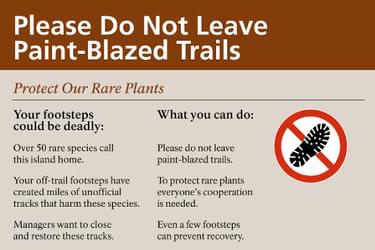
An adaptive management program involving education and site management is recommended when a decision is made to close informal trails. An educational component is critical to communicate a clear rationale for closure - that significant resource impacts can occur in some areas if visitors travel off designated trails. Examples of impacts include the trampling of sensitive vegetation or soils, introducing or dispersing invasive plants, or disturbing wildlife or rare species. A rationale message should be followed by a plea for visitors to remain on formal trails, which need to be clearly designated (e.g., blazing, symbolic markers, cairns) to distinguish them from informal trails. Social science research and theory has found that signs with a compelling rationale and clear behavioral plea are more effective than simple “do” and “do not” messages (e.g., “Please Stay on Designated Trails to Preserve Sensitive Vegetation”) (Cialdini 1996, Cialdini et al. 2006, Johnson & Swearingen 1992, Marion & Reid 2007, Vande Kamp et al. 1994, Winter 2006).
Educational programs should ensure that visitors are aware that: 1) trampling impacts represent a significant threat to resource protection in some areas, 2) remaining on formal trails avoids these impacts, and 3) that formal trails can be distinguished from informal (visitor-created) trails by distinctive markings. Examples of signs that accomplish these objectives and that have received NPS approval for use are depicted in Figure 1. Note the inclusion of the “no-step” icons that communicate the message with just a glance and are understandable by children and non-English speaking visitors.
Site management actions include maintaining and improving formal or informal trails to more clearly identify the “preferred” trail and reduce use of unnecessary secondary or braided trails, particularly in meadows or wet areas. Maintenance of formal trails to improve tread drainage or clearly mark trail borders with logs, widely spaced rocks, or scree walls, can provide needed visual cues to deter off-trail traffic. Such improvements, along with improved marking on formal trails (e.g., over-blazing) can help visitors remain on the formal trail and distinguish it from informal trails. Most park managers have ignored informal trail networks, particularly with respect to tread maintenance. However, extending maintenance work to informal trails with sustainable designs reduces impacts on trails left open to use. For example, managers can piece together a single sustainable route in an area with numerous braided trails and trim obstructing vegetation, enhance tread drainage, and install natural-appearing rockwork on steep slopes. These actions encourage use and reduce impacts on the sustainable route while reducing use and encouraging natural recovery on alternate non-maintained trails.
A variety of site management actions are available for closing informal trails. Close lightly used trails by actions that naturalize and hide their tread disturbance, particularly along initial visible sections where visitors make the decision to venture down them. Effective actions include raking organic debris such as leaves onto the tread, along with randomly placed local rocks, gravel, and woody debris designed to naturalize and hide the tread. These actions also lesson soil erosion and speed natural recovery. On trails that have been effectively closed, transplanting plugs of vegetation at the beginning of wet seasons can hasten natural recovery. Revegetation work conducted before successful closure is a waste of time and materials if visitors continue use of the trail and trample the transplanted vegetation.
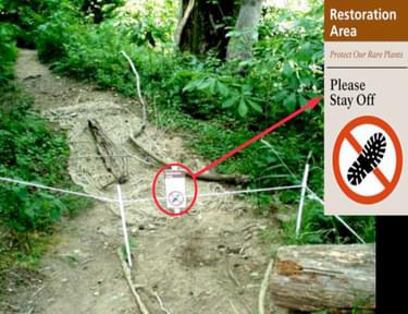
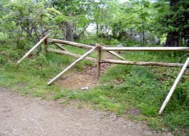
For well-used trails, such work generally cannot fully disguise the disturbed substrates and vegetation so additional measures are necessary for effective closures. Construct a visually obvious border along the main trail, such as a row of rocks or a log, to communicate an implied blockage for those seeking to access the closed trail. Alternately, embed large rocks or place large woody materials or fencing to obstruct access at the entrance to closed trails to fully clarify management intent. Even temporary 2 ft tall post and cord symbolic fences can communicate the importance of closures and effectively deter traffic (Figure 2) (Park et al. 2006). Taller plastic fencing is also easy to transport and install to discourage traffic on trails that prove more difficult to close.
Placing rocks or woody debris that physically obstructs traffic beyond the beginning of closed trails may be ineffective if visitors are able to circumvent these by walking around them. This can result in new trampling and trails parallel to the “closed” trail – a significant problem if such areas support sensitive or rare vegetation. In such areas it is better for hikers who ignore closures to remain on the “closed” tread than to create new treads on each side (Johnson et al. 1987). If the trail is in sloping terrain its closure may require the addition of soil to fill ruts and reestablish the original surface contour. Finally, integrating site management work with temporary educational signs may be necessary to obtain a level of compliance that allows vegetative recovery (Figure 1). Also, consider signs to communicate the location of a preferred alternate route when visitors are seeking to reach a particular destination and their only visible access trail is closed.
The installation and maintenance of educational and site management actions can be assigned as a collateral duty to those staff who spend the most time in the field. Informal trail management actions should be implemented as part of an ongoing adaptive management program Experimentation will be necessary to refine site management procedures that are appropriate in each management zone or location.
Some form of periodic monitoring is critical to program success. A 5-year interval could be sufficient for monitoring with quantitative procedures, but annual informal evaluations are needed to effectively guide the application of management actions. Objective monitoring will be needed if any potentially controversial management actions may be needed (e.g., use restrictions or high fencing).
In exceptionally high use areas with sensitive resources there is a good probability that such actions will be necessary. For example, a combination of signs and restoration work may be able to keep 95% of visitors on a designated trail but 5% of 2000 visitors/day is 100 visitors/day, a level of trampling that is sufficient to both create and maintain existing informal trails. A regulatory sign that prohibits use of the closed trail and threatens fines may be necessary on trails that are particularly difficult to close. Such situations may also indicate a need for further dialogue with trail users to discover their motives and a review of whether the formal trail system should be extended or modified.
Regardless, periodic monitoring provides feedback for gauging the success of management interventions in keeping conditions within acceptable limits. A documented failure of one intervention can be used to justify the use of a more obtrusive or expensive intervention.
Trail Indicators
The number, lineal extent and condition of informal trails are attributes that can be assessed as indicators of impact for informal trail systems.
Trail Condition Cass Systems
Trail condition class systems can be applied to an entire trail (if in uniform condition) or to segments. For the latter you would push a measuring wheel down the trail (or use GPS) and ascribe a condition class rating to segments of the trail in uniform condition. You might need to have a minimum distance rule (like 30 ft as the smallest segment that can be labeled as a new condition class).
Numerical
Class 1: >10% vegetation cover on trail
Class 2: <10% vegetation cover and less than 20 inches (0.5m) wide
Class 3: <10% vegetation cover and > 20 inches wide
Comments: Only 3 categories, though that's easy to apply and should be fine for most areas (additional categories could be added). The criteria (10% and 20 inches) could be modified if needed. Judging the 10% vegetation cover might be somewhat difficult in some places due to patchy vegetation.
Descriptive
Class 0: Trail barely distinguishable; no or minimal disturbance of vegetation and/or organic litter.
Class 1: Trail distinguishable; slight loss of vegetation cover and/or minimal disturbance of organic litter.
Class 2: Trail obvious; vegetation cover lost and/or organic litter pulverized in primary use areas.
Class 3: Vegetation cover lost and/or organic litter pulverized within the center of the tread, some bare soil exposed.
Class 4: Nearly complete or total loss of vegetation cover and organic litter within the tread, bare soil widespread.
Class 5: Soil erosion obvious, as indicated by exposed roots and rocks and/or gullying
Comments: More categories but less quantitative. Potentially has a greater possibility for subjectivity in application or differences in interpreting findings.
Literature Cited
Cialdini, R.B. 1996. Activating and aligning two kinds of norms in persuasive communications. Journal of Interpretation Research 1(1): 3-10.
Cialdini, R.B., Demaine, L.J., Sagarin, B.J., Barrett, D.W., Rhoads, K. & Winter, P.L. 2006. Managing social norms for persuasive impact. Social Influence 1(1): 3-15.
Cole, D.N. 1983. Assessing and monitoring backcountry trail conditions. USDA Forest Service Research Paper INT-303. 10 p.
Johnson, D.R. & Swearingen, T.C. 1992. The effectiveness of selected trailside sign texts in deterring off-trail hiking, Paradise Meadow, Mount Rainier National park. In: H.H. Christensen, D.R. Johnson, and M.M. Brooks (eds.) Vandalism: Research, Prevention and Social Policy (General Technical Report PNW-GTR-293) (pp. 103-119). Portland, OR: USDA Forest Service, Pacific Northwest Region.
Leung, Y.F. & Marion, J.L. 2000. Recreation impacts and management in wilderness: A state-of-knowledge review. In D.N. Cole & S.F. McCool (Compilers), Proceedings: Wilderness science in the time of change (pp. 23-48). Ogden, UT: USDA Forest Service, Rocky Mountain Research Station.
Marion, J.L. & Leung, Y.F. 2001. Trail resource impacts and an examination of alternative assessment techniques. Journal of Park & Recreation Administration 19(1):17-37.
Marion, J.L. & Reid, S.E. 2007. Minimising visitor impacts to protected areas: The efficacy of low impact education programmes. Journal of Sustainable Tourism 15(1): 5-27.
National Park Service. 1997. The Visitor Experience and Resource Protection (VERP) framework: A handbook for planners and managers. Publication No. NPS D-1215. Denver, CO:USDI National Park Service, Denver Service Center.
Park, Logan O., Jeffrey L. Marion, Robert E. Manning, Steven R. Lawson, Charles Jacobi. 2008. Managing Visitor Impacts in Parks: A Multi-Method Study of the Effectiveness of Alternative Management Practices. Journal of Parks and Recreation Administration 26(1): 97-121.
Stankey, G.H., Cole, D.N., Lucas, R.C., Peterson, M.E., Frissell, S.S. & Washburne, R.F. 1985. The Limits of Acceptable Change (LAC) System for wilderness planning. USDA Forest Service General Technical Report INT-176.
Vande Kamp M., Johnson, D. & Swearingen, T. 1994. Deterring Minor Acts of Noncompliance: A Literature Review. Tech Rep. NPS/PNRUN/NRTR-92/08. Cooperative Park Studies unit College of Forest Resources, AR-10, University of Washington.
Winter, P.L. 2006. What is the best wording to use on signs? The impact of normative message types on off-trail hiking. Journal of Interpretation Research 11(1): 35-52.
Attached document published August 2019

Jeff Marion is a Federal Scientist with the US Geological Survey, and is based out of Virginia Tech as an Adjunct Professor. His research specialty is Recreation Ecology, in which he investigates the environmental impacts of visitor use in protected natural areas, primarily national parks. His research has focused on visitor impacts to trails and campsites and the development of sustainable “Best Management Practices.” He was a founding member of the Leave No Trace Board of Directors, chaired the committee that guided development of the Leave No Trace principles and practices, and authored the LNT Center’s official book “Leave No Trace in the Outdoors.”
Contact: [email protected]
posted Apr 17, 2024
This report summarizes guidance and best practices to create safer bicycle facilities and connect them into networks that allow more people to safely bike to more places within and throughout communities.
Setting Speed Limits for Health and Safety
posted Apr 17, 2024
This mini-report on setting speed limits shows the current framework for speed limit policies through a review of state laws that set speed limits.
posted Nov 14, 2023
These case studies reveal a number of lessons learned that will be valuable in future winter travel management planning efforts.
TRAILS SAFE PASSING PLAN: STOP, SPEAK, and STAND BACK
posted Feb 14, 2023
Horses are prey animals and naturally can be afraid of unfamiliar people and objects. Horses have natural "flight“ survival instincts and prefer to move their feet towards an exit route. Therefore, people with horses should pass at a walk while other trail users remain STOPPED until passed.
5,257 views • posted 08/30/2019