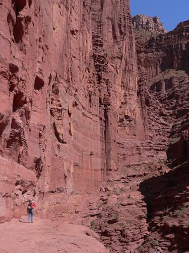
Managed by the Bureau of Land Management, this 2.2-mile backcountry trail provides access to one of the most unique geological hikes in North America.
Designated in 2007
• View more details for this trail
in the NRT Database
• Learn about the NRT Program.
The Fisher Towers Trail allows visitors to the Moab and Arches National Monument area to hike among the world-renowned towers of the Colorado Plateau. Improvements to the trail have been funded with Recreational Trails Program dollars.
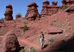
The Fisher Towers are among the most outstanding scenic features of Utah's Colorado Riverway. These rock pinnacles soar above a maze of red and purple hued canyons. Visitors to the Fisher Towers Recreation Site will be rewarded with a sweeping view of the towers, Castle Rock, the cliff-enclosed Richardson Amphitheater, and the Colorado River.
The Bureau of Land Management administers the Fisher Towers Recreation Site, a small campground and trailhead, located at the base of the towers. Facilities at the recreation site include a vault toilet, fire grills, and picnic tables. There is no drinking water.
The hiking trail along the base of the towers offers excellent views of these carved piles of hardened mud and adjacent canyon systems. The trail is 2.2 miles long and it takes most people three to four hours to make a leisurely round trip. While there are numerous stopping points with striking views, an outstanding view of the area may be obtained by hiking out halfway along the trail to the base of the Titan.
While camping or walking the trail, listen to the scrub jays and the ravens. Notice a juniper tree growing out of a crack in the rock. Try to get a close view of a lizard. These living components of the environment are as much a part of the "scenery" as the Fisher Towers.
The Fisher Towers are composed of the Organ Rock Tongue of the Cutler geologic formation capped by rock of the Moenkopi formation. The Towers are isolated remnants of a 225 million year old floodplain deposit of the Uncompahgre highland, which was located in western Colorado. When the Colorado Plateau was uplifted, salt deposits underlying this region buckled, warped, and collapsed. Subsequent erosion caused the formation of valleys and cliff escarpments.
The highest tower, the 900 foot Titan, was first climbed in 1962 by three men from Colorado. Although the crumbly texture of the towers offers less than ideal conditions, rock climbing is now relatively common in this area as a result of recent developments in climbing techniques and equipment.
Trail Activities
The Fisher Towers Hiking Trail is closed to motorized use and mountain bike travel. The route of the Fisher Towers Hiking Trail is marked by cairns (small rock piles) where it crosses areas where the path of the trail is not obvious. If you find yourself scrambling down ledges, retrace your route until you locate the trail.
There is no water along the trail so come prepared. In the summer, a gallon of water per day per person is recommended. Sturdy walking shoes or light boots are also a good idea. Be careful if you are walking the trail during or after a rainstorm. Erosive forces are still at work and falling rocks are a hazard. The trail skirts unfenced drop-offs. Parents should watch children carefully and caution them about the danger of falling.
Fisher Towers and the country along the Colorado River may look familiar. They have served as a scenic back drop for at least two dozen motion pictures, as well as videos and commercials. The Western style films Wagon Master, Against A Crooked Sky, The Comancheros, and Rio Conchos all featured views of Fisher Towers. One scene with Richard Boone in Against A Crooked Sky was filmed next to the Fisher Towers Recreation Site parking area.
Fisher Towers Recreation Site is northeast of Moab at the end of a 2.2 mile long graded dirt access road. The road to Fisher Towers begins near highway mile marker 21 along Utah Scenic Byway 128.
Bureau of Land Management, Moab Field Office, 82 East Dogwood, Moab, Utah 84532 - Phone: (435) 259-2100
Blackstone River Bikeway, Rhode Island
posted Apr 14, 2024
The Blackstone River Bikeway takes you through the heart of the Blackstone Valley. Peddle past historic mills, workers housing, the Blackstone Canal, the Providence and Worcester Railroad, and the Blackstone River itself.
Twenty Mule Team Trail, California
posted Mar 17, 2024
For many people, nothing symbolizes Death Valley more than the famous Twenty Mule Teams.
Hillman Heritage Trail, Kentucky
posted Mar 17, 2024
Located in Hillman Ferry Campground, portions of the trail follow a long-abandoned road that once carried old cars, wagons, and horses to the Tennessee River at Hillman Ferry.
Desert Ecology Trail, Saguaro National Park, Arizona
posted Feb 19, 2024
Located in the Sonoran desert, this paved interpretative, signed trail gives an overview of the plants, animals, and weather encountered in the desert.
3,907 views • posted 03/27/2018