This resource highlights ways that different communities have mapped their existing and proposed bicycle networks. It shows examples of maps at different scales, while also demonstrating a range of mapping strategies, techniques, and approaches. Facility types represented on the respective maps and legends are each different because they represent a community’s unique context and needs.
by Federal Highway Administration
Connected pedestrian and bicycle networks make walking, wheeling, and bicycling viable transportation choices for everyone. Networks enhance access to jobs, schools, and health care, while also promoting equity, physical activity, and health. Connected networks are comprised of a range of facility types (e.g. bike lanes, separated bike lanes, shared use paths, etc.), linked together to facilitate short trips to and from destinations and long linear connections across a city or region.
A first step to achieving connected networks is to document where bicycling infrastructure currently exists. It is also essential to establish a vision for the future network. This vision is often captured in the form of a map and it’s developed as part of a local planning process that includes opportunities for public participation and input.
A community’s existing and proposed bicycle network maps inform the day-to-day programming and prioritization of projects and help to ensure that all transportation improvements are enhancing the quality of the nonmotorized network and capturing opportunities to make linkages between existing and new facilities.
Attached document published June 2016

The Federal Highway Administration (FHWA), part of the US Department of Transportation, provides expertise, resources, and information to improve the nation's highway system and its intermodal connections. The Federal-Aid Highway Program provides financial assistance to the States to construct and improve the National Highway System, other roads, bridges, and trails.
posted Apr 17, 2024
This report summarizes guidance and best practices to create safer bicycle facilities and connect them into networks that allow more people to safely bike to more places within and throughout communities.
Making Transportation Planning Applicable in Tribal Communities Research Study: Final Report
posted Dec 20, 2023
The Federal Highway Administration’s (FHWA) Office of Tribal Transportation (OTT) planning staff have observed two challenges in Tribal transportation planning: (1) that existing planning analysis tools do not always align with Tribal community context and needs and (2) it is not always clear what benefits planning provides to transportation project selection and delivery in Tribal communities.
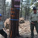
Tribal Development of Trails and Other Dedicated Pedestrian and Bicycle Infrastructure
posted Dec 19, 2023
This white paper provides information and resources for Tribes, Tribal trails and active transportation advocates, and agencies that may partner with Tribes on trail projects including Federal and State agencies, MPOs, county and local governments, and community organizations.
Rails to Trails Conservancy's TrailNation™ Playbook
posted Dec 13, 2023
Rails to Trails Conservancy's TrailNation™ Playbook brings the decades of experience building trail networks across the country to a resource of case studies, best practices and tools for trail network development on a local and national level.
372 views • posted 08/03/2020