The trail system consists of seven trails, accessible from the Visitor Center, that provide the opportunity to observe the seven distinct habitats of Back Bay National Wildlife Refuge (BBNWR).

Designated in 2022
• View more details for this trail
in the NRT Database
• Learn about the NRT Program.
Back Bay National Wildlife Refuge (BBNWR) was established in 1938 and is one of more than 565 refuges administered by the U.S. Fish and Wildlife Service. The National Wildlife Refuge System is the only network of lands and water managed specifically for the protection of wildlife management in the world.
BBNWR encompasses more than 9,175 acres and is managed primarily for migratory birds, particularly for wintering waterfowl, migratory shorebirds, and wading birds. It is located along the Atlantic Flyway adjacent to the Atlantic Ocean and Back Bay, completely within the city of Virginia Beach in southeast Virginia. BBNWR is comprised of emergent freshwater marsh, beach, dune, grassland shrub, and maritime forest, all of which provide excellent opportunities for birding. More than 300 species of birds have been recorded on the refuge. It has a 950-acre freshwater impoundment complex fed by water from Back Bay, managed specifically to provide habitat for migratory birds.
The refuge hosts between 115,000 and 215,000 visitors annually from all over the world. Visitors come to enjoy the exceptional birding opportunities, both saltwater and freshwater fishing, kayaking and canoeing, photography, and environmental education and interpretive programs. Guided interpretive tram tours are offered to visitors through BBNWR into neighboring False Cape State Park. A recently renovated Visitor Center offers information about the refuge, brochures, and wildlife displays.
The trail system at BBNWR is a component of the Virginia Beach Bikeways and Trails network. It is the first National Recreation Trail designated on a national wildlife refuge in Virginia. The trail system consists of seven trails, accessible from the Visitor Center, that provide the opportunity to observe the seven distinct habitats at the rufuge:
Charles Kuralt Trail. This is one in a system of trails at 11 national wildlife refuges and one national fish hatchery in the southeastern Virginia and northeastern North Carolina region. The trail system is dedicated to Charles Kuralt, the radio and TV host of “On the Road.” His programming brought the beauty and mystery of national wildlife refuges to people all across the country. At BBNWR, the Kuralt Trail consists of a 0.1-mile walk through shrubby trees to an overlook into a cove in Back Bay.
Seaside Trail. Two trails lead through the dunes to the beach. The Seaside Trail is adjacent to the parking area and the quickest way to visit the Refuge beach. Visitors meander through marsh, shrubby trees, and dunes on the 0.25-mile walk to the beach.
Dune Trail. The Dune Trail is located approximately 0.3 miles from the Visitor Center and parking area, down the beginning of the Dike Trail system. This is a raised boardwalk trail that leads visitors .16 miles through the dunes and out to the Refuge beach.
Reese F. Lukei, Jr. Raptor Trail. Commonly referred to as the Raptor Trail, this is the most popular hiking trail at the wildlife refuge. Located directly behind the Visitor Center, this 0.4 mile (one-way) trail takes visitors through bald cypress stands, freshwater marsh, along a small pond and to viewing platforms overlooking Back Bay.
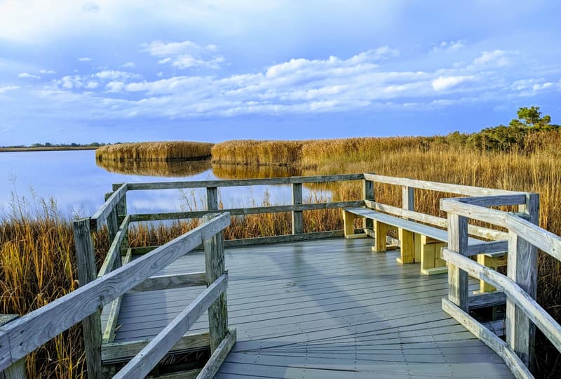
Sunset Point Trail. If you are looking for a short loop walk along the bay, the Sunset Point Overlook Loop is the trail for you. A raised boardwalk takes visitors on a 0.25-mile walk along Back Bay, with a viewing platform facing south and west into the bay itself. As the name suggests, sunsets from this spot are beautiful.
East Dike Trail. The longest trails at the Refuge are the East and West Dike trails. The East Dike Trail starts approximately three-quarters of a mile from the Visitor Center and parking area.
West Dike Trail. The West Dike Trail starts approximately half a mile from the Visitor Center and parking area. Visitors may hike or bike along this trail all the way to False Cape State Park.
There are many opportunities for outdoor recreation at the Refuge. Visitors enjoy hiking, biking, wildlife observation and photography, kayaking, and both freshwater and surf fishing. The Refuge grounds are located at 4005 Sandpiper Road, Virginia Beach, Virginia and are open sunrise to sunset, daily.
Photos Provided by U.S. Fish and Wildlife Service
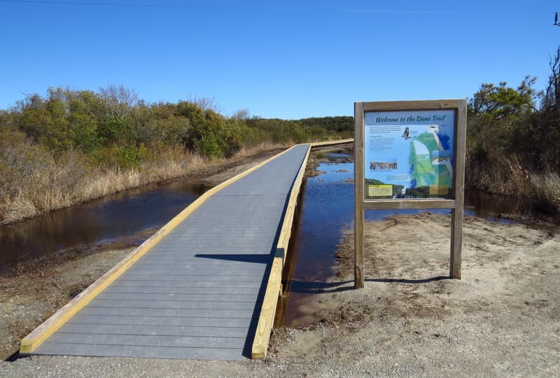
Dune Trail at the BBNWR
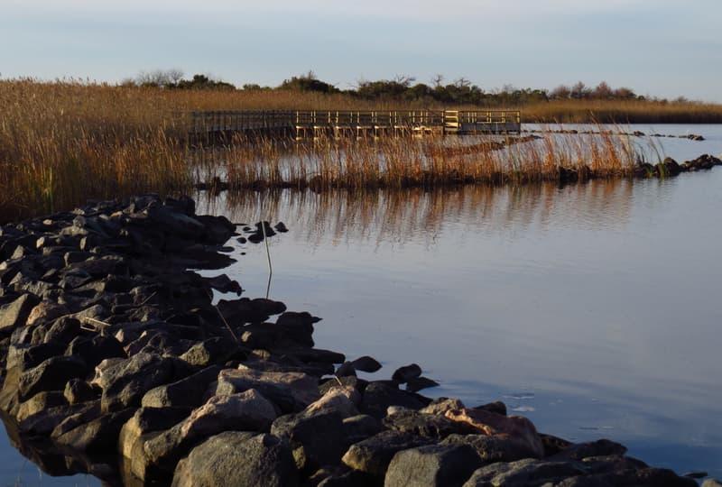
The Sunset Point Trail at BBNWR leads to a viewing platform facing into the bay.
The Kuralt Trail at BBNWR is dedicated to Charles Kuralt., the radio and TV host of “On the Road.”
Blackstone River Bikeway, Rhode Island
posted Apr 14, 2024
The Blackstone River Bikeway takes you through the heart of the Blackstone Valley. Peddle past historic mills, workers housing, the Blackstone Canal, the Providence and Worcester Railroad, and the Blackstone River itself.
Twenty Mule Team Trail, California
posted Mar 17, 2024
For many people, nothing symbolizes Death Valley more than the famous Twenty Mule Teams.
Hillman Heritage Trail, Kentucky
posted Mar 17, 2024
Located in Hillman Ferry Campground, portions of the trail follow a long-abandoned road that once carried old cars, wagons, and horses to the Tennessee River at Hillman Ferry.
Desert Ecology Trail, Saguaro National Park, Arizona
posted Feb 19, 2024
Located in the Sonoran desert, this paved interpretative, signed trail gives an overview of the plants, animals, and weather encountered in the desert.
792 views • posted 10/03/2022