The award recognizes a project that demonstrates outstanding planning, design, and implementation, that enhances the trails movement in the specified location. Submissions describing the trail, greenway (or trail or greenway system), or blueway including successful aspects such as planning, design, challenges solved, public participation, sustainability, economic benefits, promotion, and benefits to the local community are encouraged. Level Two: Projects funded $1.5 million or more.
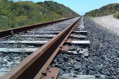
Existing rail line
The Monterey Bay Sanctuary Scenic Trail Network Master Plan defines a 50-mile network of multi-use bicycle/pedestrian trails spanning the length of Santa Cruz County.
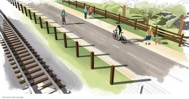
The spine of the network will be within the 32 mile rail right-of-way adjacent to the operating rail line (aka the “rail trail”) and spur trails will connect to desirable destinations.
The trail will expand transportation options for residents, tourists, people with mobility impairments, commuters and others for generations to come and will eventually arc the Monterey Bay National Marine Sanctuary from the San Mateo/Santa Cruz County line to Pacific Grove in Monterey County.
The Master Plan merges multiple community priorities, namely separated bike/pedestrian facilities for active transportation purposes and facilities that provide coastal connectivity, into one cohesive planning document. The Master Plan divides the approximately $127M network into 20 trail segments that can be constructed as funding become available; describes the look and feel of the variety of trail and facility types proposed; offers construction cost estimates per segment; offers trail design options; addresses interface with rail and agricultural operations; and discusses trail construction, management and maintenance mechanisms. along the trail corridor and natural grassy swales provide drainage without the extensive use of drain pipes.
After being championed by Congressman Farr for over a decade, the Monterey Bay Sanctuary Scenic Trail Network was solidified by the adoption of the project’s Master Plan in final form in 2013. Much community investment and championship moved the project forward. Almost $7M has been secured for Trail Network planning and implementation of which $2.5M came from the federal Transportation Enhancement program and approximately $4.5M is due to Congressman Sam Farr’s efforts.
The California Coastal Conservancy also contributed funding towards development of the Master due to the fact that the Trail Network will serve as the California Coastal Trail throughout Santa Cruz County. Because of the adoption of the Master Plan in November, 2013, the RTC was able to allocated $5.3M in funds immediately thereafter to construct three projects identified in the Master Plan.
Approximately 50% of the county’s population, as well as 88 parks and 42 schools, are located in census tracks that are within 1 mile from the rail corridor. Trail Network will not only serve a large percentage of the local population but will also serve visitors wishing to enjoy the Santa Cruz County portion of the 1,300-mile California Coastal Trail initiative which will draw many visitors to the county.
The USDOT estimates that about 40% of all car trips are three miles or less. These short trips use more fuel per mile, generate more emissions per mile, and in particular cause more climate change per mile than any other trips. It is these shorter trips that can most readily be converted, given facilities attractive to the general population, to non-motorized alternatives. The Master Plan lays the foundation for such facilities that are sure to become invaluable assets for not only residents but also visitors, natural habitat conservationists, and potential stewards of the environment.
The Master Plan is a major accomplishment, the product of years of work and an enormous outpouring of public participation. Most importantly, it demonstrates the extraordinary range of benefits that a superb trail can bring to a community. These benefits include environment, health, economic vitality, greater public understanding and appreciation of our coastline, improved transportation efficiency, and vastly increased accessibility.
The Master Plan for the Trail Network was needed to serve a guiding document for the project’s long term implementation. The Master Plan establishes the continuous alignment for the trail project and identifies planning issues associated with the trail’s implementation.
Specifically, the Master Plan achieves the following:
As a result of the Plan’s adoption in 2013, initiatives to raise private funding to leverage public funds began in full earnest with significant commitments made to supplement an initial funding allocation of $5.3 million in December, 2013 to three projects.
452 views • posted 01/10/2018