
Principal work items of this grant include relocation of Kekekabic Trail and relocation of trail connection between Bingshick and Glee Lakes. A few existing segments of the Kekekabic Trail are under water because of beaver activity and lake level fluctuation. Hikers attempting to avoid the deep water currently make their own alternate routes that damage aquatic vegetation and fragment riparian habitats. New trail routes will be located on upland areas making them more resilient. They will also be reviewed for potential cultural resource impacts and constructed using sustainable trail construction techniques thus reducing the potential of future wetland impacts
More Project Details:
1. Relocation of Kekekabic Trail near Seahorse Lake. Existing Trail was constructed in a wetland area adjacent to the Lake. Due to fluctuating water levels and use of the Trail, multiple trail locations have been established in an effort to avoid getting feet (and up to knees) wet. This section of trail is located below a rock outcropping and the Lake preventing a minor reroute. A 0.65 mile section of the trail will ascend the bluff and reconnect to the trail as it climbs through an ephemeral stream valley. The Trail relocation will be flagged and mapped by USFS Personnel and Kekekabic Trail Chapter (KTC) Volunteers. Tread construction and clearing will be completed by a CCMI Crew (est. 2 weeks). Ongoing brushing, clearing and other maintenance will be by KTC Volunteers.
2. Relocation of trail connection between Bingshick and Glee Lakes. The existing trail is collocated with canoe portage that connects these two lakes. Canoe portages were historically located at stream connections of Lakes to provide the shortest distance. Unfortunately, the same locations are frequently flooded or wet. I this case, the canoe portage begins at Bingshick in a White Cedar bok and passe along a drainage up to Glee Lake. This 0.19 Mile Reroute of the Trail will relocate the hiking Trail on high ground adjacent to the Canoe Portage. Additionally, the two T-intersections of the trail and portage will be combined into one 4-legged (perpendicular) intersection to avoid confusion of hikers and canoeists. The Trail relocation will be flagged and mapped by USFS Personnel and Kekekabic Trail Chapter (KTC) Volunteers. Tread construction and clearing will be completed by a CCMI Crew (est. 2 weeks). Ongoing brushing, clearing and other maintenance will be by KTC Volunteers.
3. New Trail Connection between the Border Route (Magnetic Rock) and Kekekabic Trails. These trails are both part of the North Country Trail. The trailheads for the Kekekabic Trail and the Border Trail are located approximately a quarter mile apart on the Gunflint Trail. There is currently no off-road connection between these two trails so (Through)hikers must hike along a 55 MPH highway with little to no shoulder to access the next segment of trail. The Trail relocation will be flagged and mapped by USFS Personnel and Kekekabic Trail Chapter (KTC) Volunteers. Tread construction and clearing will be completed by a CCMI Crew (est. 2 weeks). Ongoing brushing, clearing and other maintenance will be by KTC Volunteers.
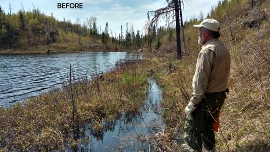
4. Warclub Lake - The trail near Warclub Lake crosses a Stream between Fay and Warclub Lake. Currently the crossing consists of parallel logs at the top of a falls into Warclub Lake. USFS Staff will assess the most ecological method for assuring a safe trail access across this stream. KTC Volunteers will work to improve the existing crossing based on the USFS Findings. The Trail crossing where it crosses the Portage between these two Lakes will be clarified by appropriate corridor definition (Clearing).
Timeline - The USFS has already begun the preliminary data collection necessary to start meet the National Environmental Protection Act (NEPA) requirements. In Spring 2023, USFS Personnel and KTC Volunteers will conduct on-site visits to define the proposed trail corridor. Environmental and archeological specialists will survey the proposed impact acres to determine the presence or absence of significant resources.
In May 2023, Kekekabic Trail Crews will conduct maintenance on and improvement of the trail in areas that are not subject to NEPA review (eg. Campsite maintenance, Board Walk Repair, Brush Removal, etc.
By July 2023, it is anticipated that a final alignments will be flagged and located on the ground.
Once the NEPA study is concluded (Fall/ Winter 2023), volunteer crews of Kekekabic Trail Chapter and Border Route Trail Association will be recruited to conduct brushing along the proposed corridors. Conservation Corps of Minnesota and Iowa (CCMI) will be requested construct the Trail and clear trees as necessary. It is anticipated that all work on the new Trail Connections will be concluded by Fall, 2024.
2024: Highline Trail
2024: Teton Trails Deferred Maintenance
2024: Phase 2 of the Arroyo Hondo Project
2024: Greenhorn Gulch Trail Reroute and Bridge Rebuild
2024: Trail Rehabilitation in Beaverhead Deer Lodge National Forest
2024: Trail Maintenance and Repairs in Pisgah National Forest
2024: Wasatch National Forest Deferred Maintenance and Weather Resilience
2024: Rio Fernando de Taos Watershed Revival
2024: Mineral Creek Trail Reroute
2024: Second Fork Trail Project
2024: Trinity River Watershed Trail Improvement Project
2024: Salmon-Challis National Forest Trail Restoration
2024: Manistee, White, Muskegon, and Pere Marquette River Watershed
2024: Mount Shavano Trail and Riparian Habitat Restoration Project
2024: South Park Ranger District Singletrack Connector Trail
2024: Oak Creek Canyon Watershed Restoration Project
2024: Bartram National Recreation Trail Maintenance
2024: Idaho Panhandle National Forest Sandpoint Ranger District Trail Reroute
2024: Pony Express National Historic Trail Improvement
2024: South Lake and Moss Lake Trail Restoration
2024: West Ridge Trail #176 Improvements
2024: Blue Bend Loop Trail Restoration
2024: Catamount Trail Improvement
2024: Munson Meadow Trail Restoration
2024: Vesuvius Recreation Area Trail System Restoration
2024: Hurricane Creek Trail Restoration
2024: Cove Creek Trail Rehabilitation
2023: The Storm Creek Connector Trail
2023: Backpacker and Lakeshore Trails
2023: Beaver Meadows Trail
2023: Munson Meadow Trail
2023: Imnaha River Trail
2023: Maxon Meadows Trail to Chamberlain Meadows Camp
2023: Lost Lake Trail
2023: Virginia Highlands Horse Trail
2023: Pasayten Wilderness Project
2023: Catawba River Headwaters
2023: Continental Divide National Scenic Trail
2023: Southfork Trail, White Mountain Wilderness
2023: Black Canyon and Trail Creek Drainages
2023: Twenty Lakes Basin Toads and Trails
2023: Dickey Bell Trail Reroute and Bypass
2023: Horseshoe Canyon Trails
2023: Lower San Francisco River Wilderness Study Area
2023: Trails in Ontonagon and Sturgeon watersheds
2023: Bandit Springs Trail System
2023: Caton Lake Trail
2023: Yellowbelly Trail
2023: Santa Cruz Trail
2023: Bridge Replacement for Trail Access
2023: Pioneer Mountains Trail Maintenance
2023: Pincushion Mountain Ski Trails
2023: Rocky Gap Horse Trail System
2023: Shrode Lake Trail
2023: Johnson Creek Trail Re-Establishment
2023: Soda Ditch Loop Trail
2023: Restoration of Buckhorn and Indian Trails
2023: Hauf Lake and One Horse Lakes Trails
2023: Building Resilience on the TRT/PCT
2023: Camp Creek Watershed Improvement
2023: Pomas Creek Trail and Entiat River Trail
2023: Western States Trail & Tevis Cup Trail, within Granite Chief Wilderness
2023: Western States Trail Improvements
2023: Sipsey Wilderness Trails Restoration
238 views • posted 05/24/2023


