
Construction and Design
Diana Bend Conservation Area Trail Project - Missouri
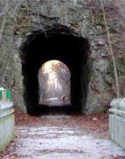
Tunnel on the Katy rail trail
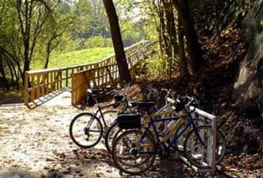
Visitors can now access the conservation area via the Katy Trail.
The Rocheport segment is one of the most scenic and heavily used sections of the 225-mile long Katy Trail, a rail trail with approximately 400,000 visitors per year along this stretch of trail. Many of these visitors will now be able to enjoy one of both of the new trails and viewing opportunities at Diana Bend Conservation Area.
The trails now accommodate visitors to the area looking for additional hike and wildlife viewing opportunities, and those wishing to explore the ongoing Missouri River floodplain restoration. Access to the portion of Diana Bend Conservation Area containing the new trails is by foot or bicycle from the adjacent Katy Trail State Park.
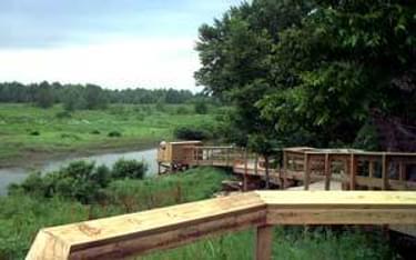
Two trails were built: a disabled accessible wood boardwalk and a natural surface hiking trail with each segment incorporating a large viewing platform. In addition, the boardwalk leads to a wildlife viewing blind.
The disabled accessible trail begins just off the Katy Trail and is surfaced with crushed aggregate similar to the rails to trails construction. After about 170 feet there is a transition to a wood boardwalk. The boardwalk parallels a steep limestone bluff as it gradually rises on piers to the height of a levee surrounding the wetlands.
It then opens into an 18 x 18 foot platform overlooking the wetlands. From the platform, the boardwalk continues along the front of the bluff and zig-zags down to a wildlife viewing blind. The disabled-accessible viewing blind provides up-close views of the floodplain, wetland restoration and river wildlife. The total length of the wood boardwalk is 392 feet.
Back at the viewing platform on the levee, visitors may choose a more strenuous hike to the bluff top. A natural surface trail begins here with stairs transitioning to rock steps for a short distance. Just to the right at the bottom of the strains, an old rock carving was left exposed. The rocks reads: W.P. Tompkinds, Fisherman, Apr 22, 1892.
The steep trail follows the route of an old worn footpath, now widened and covered in wood chips. To help stabilize the chips and facilitate drainage, staggered up the hill are numerous waterbars built with strips of rubber conveyor belt sandwiched between boards.
Rising up to the highest point, the trail then curves back toward the edge of the bluff and ends at another 18 x 18 foot viewing deck. From this platform high above the woodplain, visitors have a commanding view of the Diana Bend Conservation Area wetlands, and glances of the Missouri River.
The wood chipped trail is approximately 570 feet long. Benches midway up the hill and at the top near the viewing deck provide convenient resting places.
More winners of this award
2023: Cacapon State Park Foundation Mountain Bike Trail Program
2023: Hawks Rest Pack Stock Bridge Installation
2021: Vermilion Falls Trail
2021: Climax Tunnel Rehabilitation
2020: Blue Ridge Tunnel Rehabilitation & Trail Project
2020: Milan Trail Huggers Nash Stream Bridge
2019: Weed Patch Mountain Trail
2018: Ouachita National Recreation Trail Shelters - Arkansas and Oklahoma
2017: Anthracite Outdoor Adventure Area - Pennsylvania
2016: Kanab Creek OHV Bridge - Utah
2015: Blanca Peak and Ellingwood Point Trail Project - Colorado
2015: Joanna Trail Project - Missouri
2014: Abbott Motocross Park - Nebraska
2014: Millersburg Historic Park and Trailhead - Michigan
2013: East and West Twin Creek Bridges - Michigan
2012: Chattahoochee Nature Trails - Florida
2012: Tahoe-Pyramid Bikeway - Nevada
2011: Iron Range OHV Recreation Area - Minnesota
2010: Agassiz Recreational Trail - Minnesota
2009: Sam Houston Multiple-Use Trail - Texas
2008: Wanoga Snopark Shelter - Oregon
2007: Potato Knob Trail at Holly River State Park - West Virginia
2006: Indian Canyon Trailhead - California
2006: Upper Waiakea ATV/Dirt Bike Park - Hawaii
2006: County Line Acres Bikeway - Ohio
2005: River Bluff Trail Project - Indiana
2005: Red Creek Bridge - Michigan
2005: MKT Trailhead Project - Missouri
2004: Sweetser Switch Trail Project - Indiana
2003: Jane Addams Trail - Illinois
2003: Hatfield-McCoy Regional Recreation Area - West Virginia